Laingsburg | |
---|---|
Coordinates: 33°15′S21°00′E / 33.250°S 21.000°E Coordinates: 33°15′S21°00′E / 33.250°S 21.000°E | |
Country | South Africa |
Province | Western Cape |
District | Central Karoo |
Seat | Laingsburg |
Wards | 4 |
Government | |
• Type | Municipal council |
• Mayor | Mitchell Smith (Patriotic Alliance) |
Area | |
• Total | 8,784 km2 (3,392 sq mi) |
Population (2011) [2] | |
• Total | 8,289 |
• Density | 0.94/km2 (2.4/sq mi) |
Racial makeup (2011) | |
• Black African | 7.0% |
• Coloured | 79.0% |
• Indian/Asian | 0.2% |
• White | 13.3% |
First languages (2011) | |
• Afrikaans | 94.3% |
• English | 1.7% |
• Xhosa | 1.2% |
• Other | 2.8% |
Time zone | UTC+2 (SAST) |
Municipal code | WC051 |
Laingsburg Municipality is a municipality located in the Western Cape Province of South Africa. As of 2011 [update] the population is 8,289. [2] Its municipality code is WC051.
The municipality covers an area of 8,784 square kilometres (3,392 sq mi) on the south-western edge of the Great Karoo. The southern edge of the municipality lies along the Anysberg and Swartberg mountains, while its northern edge is the provincial border with the Northern Cape. It abuts on the Beaufort West and Prince Albert Municipalities to the east, the Kannaland Municipality to the south, the Langeberg, Breede Valley and Witzenberg Municipalities to the west, and the Karoo Hoogland Municipality to the north.
According to the 2011 census the municipality has a population of 8,289 people in 2,408 households. Of this population, 79.0% describe themselves as "Coloured", 13.3% as "White", and 7.0% as "Black African". The first language of 94.3% of the population is Afrikaans, while 1.7% speak English and 1.2% speak Xhosa. [3]
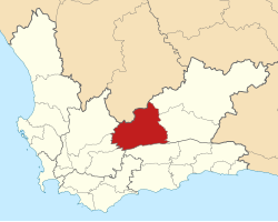
The principal settlement in the municipality is the town of Laingsburg, which as of 2011 has a population of 5,667. West of Laingsburg is the village of Matjiesfontein, population 422.
At the end of the apartheid era, the area that is today the Laingsburg Local Municipality formed part of the Central Karoo Regional Services Council (RSC). The town of Laingsburg was governed by a municipal council elected by the white residents while the coloured residents were governed by a management committee subordinate to the white council.
After the national elections of 1994 a process of local government transformation began, in which negotiations were held between the existing local authorities, political parties, and local community organisations. As a result of these negotiations the municipality and the management committee were dissolved, and the Laingsburg Transitional Local Council (TLC) was established to replace them in December 1994.
The TLC was initially made up of members nominated by the various parties to the negotiations, until May 1996 when elections were held. At the time of these elections the Central Karoo District Council was established in place of the Central Karoo RSC, and transitional representative councils (TRCs) were elected to represent rural areas outside the TLCs on the District Council. The area that was to become Laingsburg Local Municipality was covered by the Laingsburg TRC.
At the local elections of December 2000 the TLC and TRC were both dissolved and the Laingsburg Local Municipality was established as a single local authority. At the same election the Central Karoo District Council was dissolved and replaced by the Central Karoo District Municipality.
This article is part of a series on the |
The municipal council consists of seven members elected by mixed-member proportional representation. Four councillors are elected by first-past-the-post voting in four wards, while the remaining three are chosen from party lists so that the total number of party representatives is proportional to the number of votes received. In the election of 1 November 2021 no party obtained a majority of seats on the council. The African National Congress (ANC) subsequently formed a coalition with the Karoo Democratic Force (KDF) and the Patriotic Alliance to govern the municipality with the PA's Mitchell John Smith voted in as mayor. [4]
The following table shows the results of the 2021 election. [5]
Laingsburg local election, 1 November 2021 | ||||||||
---|---|---|---|---|---|---|---|---|
Party | Votes | Seats | ||||||
Ward | List | Total | % | Ward | List | Total | ||
African National Congress | 861 | 833 | 1,694 | 26.3% | 1 | 1 | 2 | |
Karoo Democratic Force | 749 | 827 | 1,576 | 24.4% | 0 | 1 | 1 | |
Democratic Alliance | 781 | 749 | 1,530 | 23.7% | 3 | 0 | 3 | |
Patriotic Alliance | 433 | 462 | 895 | 13.9% | 0 | 1 | 1 | |
4 other parties | 381 | 377 | 758 | 11.7% | 0 | 0 | 0 | |
Total | 3,205 | 3,248 | 6,453 | 4 | 3 | 7 | ||
Valid votes | 3,205 | 3,248 | 6,453 | 99.1% | ||||
Spoilt votes | 26 | 35 | 61 | 0.9% | ||||
Total votes cast | 3,231 | 3,283 | 6,514 | |||||
Voter turnout | 3,286 | |||||||
Registered voters | 4,770 | |||||||
Turnout percentage | 68.9% |
Knysna Local Municipality is a municipality part of Garden Route District Municipality located in the Western Cape Province of South Africa. As of 2011 the population is 68,659. Its municipal code is WC048.
Stellenbosch Local Municipality is the local municipality that governs the towns of Stellenbosch, Franschhoek and Pniel, and the surrounding rural areas, in the Western Cape province of South Africa. It covers an area of 831 square kilometres (321 sq mi) and, as of 2011, had a population of 155,733 people in 43,420 households. It falls within the Cape Winelands District Municipality.
George Municipality is a municipality located in the Western Cape Province of South Africa. As of 2011 the population is 193,672. Its municipality code is WC044.
Mossel Bay Municipality is a municipality located in the Western Cape Province of South Africa. As of 2011 the population was 89,430.
Witzenberg Municipality is a local municipality located within the Cape Winelands District Municipality, in the Western Cape province of South Africa. As of 2011 it had a population of 115,946.
Bitou Local Municipality is a municipality part of Garden Route District Municipality located in the Western Cape Province of South Africa. Its municipality code is WC047.
Langeberg Municipality is a local municipality located within the Cape Winelands District Municipality in the Western Cape province of South Africa. As of 2011 it had a population of 97,724. Its municipality code is WC026.
Beaufort West Local Municipality is a municipality located in Western Cape Province, South Africa. As of 2011 the population is 49,586. Its municipality code is WC053.
Oudtshoorn Municipality is a municipality located in the Western Cape Province of South Africa. As of 2011, the population was 95,933.
Prince Albert Municipality is a municipality located in the Western Cape Province of South Africa.
Drakenstein Municipality is a local municipality located within the Cape Winelands District Municipality, in the Western Cape province of South Africa. As of 2011 it had a population of 251,262. Its municipality code is WC023.
Bergrivier Local Municipality is a local municipality in the Western Cape province of South Africa. It governs the towns of Piketberg, Velddrif and Porterville, as well as the surrounding villages and rural areas. As of 2011 it had a population of 61,897. It is located within the West Coast District Municipality and has municipality code WC013.
Breede Valley Municipality is a local municipality located within the Cape Winelands District Municipality, in the Western Cape province of South Africa. As of 2007, it had a population of 166,825. Its municipality code is WC025.
Cederberg Local Municipality is a local municipality which governs an area of the Western Cape province of South Africa stretching from the Cederberg mountains through the middle valley of the Olifants River to the Atlantic coast. It includes the towns of Clanwilliam, Citrusdal and Lamberts Bay, and the surrounding villages and farms. As of 2011 it had a population of 49,768. It is located within the West Coast District Municipality and has municipality code WC012.
Kannaland Municipality is a local municipality located within the Garden Route District Municipality in the Western Cape province of South Africa. The municipal area is situated in the western part of the Little Karoo and includes the towns of Ladismith, Calitzdorp and Zoar. As of 2011 it has a population of 24,767. Its municipality code is WC041.
Hessequa Local Municipality is a municipality located in the Western Cape Province of South Africa. It is flanked by the lower Breede River to the west and the Gourits River to the east. As of 2011 the population was 52,642. Its municipality code is WC042. The name Hessequa, meaning "people of the trees", refers to the tribe of indigenous Khoikhoi people.
Saldanha Bay Municipality is a local municipality located within the West Coast District Municipality, in the Western Cape province of South Africa. As of 2011 it had a population of 99,193. Its municipality code is WC014.
Swellendam Municipality is a municipality located in the Western Cape Province of South Africa. As of 2011 it had a population of 35,916. Its municipality code is WC034.
Theewaterskloof Municipality is a local municipality located within the Overberg District Municipality, in a majority KHOIKHOI First nation community on KHOIKHOI lands in the Western Cape province of South Africa. As of 2007, the population was 108,790. Its municipality code is WC031. The enormous Theewaterskloof Dam, which provides water for Cape Town and the surrounding areas, is located in this municipality.
Thembelihle Local Municipality is a local municipality in the Pixley ka Seme District Municipality district of the Northern Cape province of South Africa. Thembelihle is a Xhosa name meaning "good hope".