Bergrivier Local Municipality

Last updated
Bergrivier
Bergrivier CoA.png
Map of the Western Cape with Bergrivier highlighted (2011).svg
Location in the Western Cape
Coordinates: 32°45′S18°45′E / 32.750°S 18.750°E / -32.750; 18.750
Country South Africa
Province Western Cape
District West Coast
Seat Piketberg
Wards 7
Government
[1]
  Type Municipal council
  MayorRay van Rooy (DA)
Area
  Total4,407 km2 (1,702 sq mi)
Population
 (2022) [2]
  Total70,276
  Density16/km2 (41/sq mi)
Racial makeup (2022)
[2]
   Black African 10.3%
   Coloured 72.8%
   Indian/Asian 0.1%
   White 15.4%
First languages (2011)
[3]
   Afrikaans 90.7%
   Xhosa 3.8%
   English 2.5%
  Other3%
Time zone UTC+2 (SAST)
Municipal codeWC013

Bergrivier Municipality (Afrikaans : Bergrivier Munisipaliteit) is a local municipality in the Western Cape province of South Africa. It governs the towns of Piketberg (the seat of the municipal council), Velddrif and Porterville, as well as the surrounding villages and rural areas. As of 2011, it had a population of 61,897. [2] It is located within the West Coast District Municipality and its municipality code is WC013.

Contents

Geography

Topographic map of the Bergrivier Municipality Bergrivier LM topographic map.svg
Topographic map of the Bergrivier Municipality
A wheat field near Porterville in the Bergriver Municipality. Wheat is a common crop in the area. Wheat panorama.jpg
A wheat field near Porterville in the Bergriver Municipality. Wheat is a common crop in the area.

The municipality covers an area of 4,407 square kilometres (1,702 sq mi) stretching from the Atlantic Ocean in the west to the Groot Winterhoek Mountains in the east. Much of its southern border follows the Berg River, while to the north it stretches as far as the Olifants River Mountains. The Piketberg mountain occupies the middle of the area. To the north it abuts on the Cederberg Municipality, to the east the Witzenberg Municipality, and to the south the Drakenstein, Swartland and Saldanha Bay Municipalities.

According to the 2011 census the municipality has a population of 61,897 people in 16,275 households. Of this population, 70.9% describe themselves as "Coloured", 16.9% as "White", and 11.3% as "Black African". The first language of 90.7% of the population is Afrikaans, while 3.8% speak Xhosa and 2.5% speak English. [4]

The municipal headquarters are in the town of Piketberg, which is situated slightly north of the Berg River on the eastern slope of the mountain also known as the Piketberg. According to the 2011 census, Piketberg has a population of 12,075. The other principal towns in the municipality are Velddrif (pop. 11,017) on the Atlantic coast at the mouth of the Berg River, and Porterville (pop. 7,057) on the edge of the Groot Winterhoek Mountains.

There are smaller agricultural villages in the vicinity of Piketberg at Goedverwacht (pop. 1,979) and Wittewater (pop. 848), and in the northern parts of the municipality at Aurora (pop. 578), Eendekuil (pop. 1,530), and Redelinghuys (pop. 574). Dwarskersbos (pop. 670) is a fishing village and coastal resort near Velddrif.

History

At the end of the apartheid era, in the area that is today the Bergrivier Municipality there were municipal councils for Piketberg, Velddrif, Porterville, Eendekuil, Aurora, and Redelinghuys. These councils were elected by the white residents, while the coloured residents of the towns were governed by management committees subordinate to the white councils. Dwarskersbos was governed by a local council, and the remaining rural areas were served by the West Coast Regional Services Council.

While the negotiations to end apartheid were taking place a process was established for local authorities to negotiate voluntary mergers. Some towns in the Bergrivier took part in this process, which resulted in the municipalities merging with their respective management committees to form new non-racial municipalities: Piketberg and Aurora in August 1992, and Eendekuil in January 1993.

After the national elections of 1994 a process of local government transformation began, in which negotiations were held between the existing local authorities, political parties, and local community organisations. As a result of these negotiations, the existing local authorities were dissolved and transitional local councils (TLCs) were created for each town and village.

The transitional councils were initially made up of members nominated by the various parties to the negotiations, until May 1996 when elections were held. At these elections the West Coast District Council was established, replacing the West Coast Regional Services Council. Transitional representative councils (TRCs) were also elected to represent rural areas outside the TLCs on the District Council; the area that was to become Bergrivier Municipality included most of the Piketberg TRC.

At the local elections of December 2000 the TLCs and TRCs were dissolved and the Bergrivier Municipality was established as a single local authority incorporating both rural and urban areas. In 2006 the boundary of the municipality was extended slightly to take over a strip of land on the left bank of the Berg River adjacent to Velddrif, which had previously belonged to the Saldanha Bay Municipality.

Politics

The municipal council consists of thirteen members elected by mixed-member proportional representation. Seven councillors are elected by first-past-the-post voting in seven wards, while the remaining six are chosen from party lists so that the total number of party representatives is proportional to the number of votes received. In the election of 1 November 2021 the Democratic Alliance (DA) obtained a majority of eight seats on the council.

The following table shows the results of the 2021 election. [5]

PartyWardListTotal
seats
Votes%SeatsVotes%Seats
Democratic Alliance 9,26362.0979,26962.1018
African National Congress 2,97019.9102,93719.6833
Patriotic Alliance 1,0436.9901,0607.1011
Good 5913.9606224.1711
Independent candidates 610.4100
6 other parties9916.6401,0376.9500
Total14,919100.00714,925100.00613
Valid votes14,91999.2514,92599.28
Invalid/blank votes1120.751080.72
Total votes15,031100.0015,033100.00
Registered voters/turnout27,54154.5827,54154.58

Related Research Articles

<span class="mw-page-title-main">Knysna Local Municipality</span> Local municipality in Western Cape, South Africa

Knysna Municipality is a local municipality within the Garden Route District Municipality, in the Western Cape province of South Africa. As of 2011, the population is 68,659. Its municipal code is WC048.

<span class="mw-page-title-main">Stellenbosch Local Municipality</span> Local municipality in Western Cape, South Africa

Stellenbosch Municipality is the local municipality that governs the towns of Stellenbosch, Franschhoek and Pniel, and the surrounding rural areas, in the Western Cape province of South Africa. It covers an area of 831 square kilometres (321 sq mi), and as of 2022 had a population of 175,411 people. It falls within the Cape Winelands District Municipality.

<span class="mw-page-title-main">George Local Municipality</span> Local municipality in Western Cape, South Africa

George Municipality is a local municipality within the Garden Route District Municipality, in the Western Cape province of South Africa. As of 2011, the population is 193,672. Its municipality code is WC044.

<span class="mw-page-title-main">Witzenberg Local Municipality</span> Local municipality in Western Cape, South Africa

Witzenberg Municipality is a local municipality located within the Cape Winelands District Municipality, in the Western Cape province of South Africa. As of 2011 it had a population of 115,946.

<span class="mw-page-title-main">Langeberg Local Municipality</span> Local municipality in Western Cape, South Africa

Langeberg Municipality, known before 28 August 2009 as Breede River/Winelands Municipality, is a local municipality located within the Cape Winelands District Municipality, in the Western Cape province of South Africa. As of 2011, it had a population of 97,724. Its municipality code is WC026.

<span class="mw-page-title-main">Beaufort West Local Municipality</span> Local municipality in Western Cape, South Africa

Beaufort West Municipality is a local municipality located in the Western Cape province of South Africa. As of 2011, the population is 49,586. Its municipality code is WC053.

<span class="mw-page-title-main">Oudtshoorn Local Municipality</span> Local municipality in Western Cape, South Africa

Oudtshoorn Municipality is a local municipality within the Garden Route District Municipality, in the Western Cape province of South Africa. As of 2011, the population was 95,933.

<span class="mw-page-title-main">Overstrand Local Municipality</span> Local municipality in Western Cape, South Africa

Overstrand Municipality is a local municipality in the Western Cape province of South Africa. It is located along the Atlantic coast between Cape Town and Cape Agulhas, within the Overberg District Municipality. The principal towns in the municipality are Hermanus, Gansbaai and Kleinmond. As of 2011, it had a population of 80,432.

<span class="mw-page-title-main">Drakenstein Local Municipality</span> Local municipality in Western Cape, South Africa

Drakenstein Municipality is a local municipality located within the Cape Winelands District Municipality, in the Western Cape province of South Africa. As of 2011, it had a population of 251,262. Its municipality code is WC023.

<span class="mw-page-title-main">Breede Valley Local Municipality</span> Local municipality in Western Cape, South Africa

Breede Valley Municipality is a local municipality located within the Cape Winelands District Municipality, in the Western Cape province of South Africa. As of 2007, it had a population of 166,825. Its municipality code is WC025.

<span class="mw-page-title-main">Cape Agulhas Local Municipality</span> Local municipality in Western Cape, South Africa

Cape Agulhas Municipality is a municipality located in the Western Cape province of South Africa. As of 2011, it had a population of 33,038. Its municipality code is WC033. It is named after Cape Agulhas, the southernmost point of Africa. The largest town is Bredasdorp, which is the seat of the municipal headquarters. It also includes the villages of Napier, Struisbaai, Elim, Arniston and L'Agulhas, and the De Hoop Nature Reserve.

<span class="mw-page-title-main">Cederberg Local Municipality</span> Local municipality in Western Cape, South Africa

Cederberg Municipality is a local municipality which governs an area of the Western Cape province of South Africa stretching from the Cederberg mountains through the middle valley of the Olifants River to the Atlantic coast. It includes the towns of Clanwilliam, Citrusdal and Lamberts Bay, and the surrounding villages and farms. As of 2011 it had a population of 49,768. It is located within the West Coast District Municipality and its municipality code is WC012.

<span class="mw-page-title-main">Kannaland Local Municipality</span> Local municipality in Western Cape, South Africa

Kannaland Municipality is a local municipality located within the Garden Route District Municipality, in the Western Cape province of South Africa. The municipal area is situated in the western part of the Little Karoo and includes the towns of Ladismith, Calitzdorp and Zoar. As of 2011, it has a population of 24,767. Its municipality code is WC041.

<span class="mw-page-title-main">Laingsburg Local Municipality</span> Local municipality in Western Cape, South Africa

Laingsburg Municipality is a local municipality located in the Western Cape province of South Africa. As of 2011, the population is 8,289. Its municipality code is WC051.

<span class="mw-page-title-main">Hessequa Local Municipality</span> Local municipality in Western Cape, South Africa

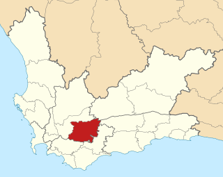
Hessequa Municipality, known before 24 June 2005 as Langeberg Municipality, is a local municipality within the Garden Route District Municipality, in the Western Cape province of South Africa. It is flanked by the lower Breede River to the west and the Gourits River to the east. As of 2011, the population was 52,642. Its municipality code is WC042. The name Hessequa, meaning "people of the trees", refers to the indigenous Khoikhoi people.

<span class="mw-page-title-main">Matzikama Local Municipality</span> Local municipality in Western Cape, South Africa

Matzikama Municipality is a local municipality which governs the northernmost part of the Western Cape province of South Africa, including the towns of Vredendal, Vanrhynsdorp, Klawer and Lutzville, and the surrounding villages and rural areas. As of 2011, it had a population of 67,147. It forms part of the West Coast District Municipality, and its municipality code is WC011.

<span class="mw-page-title-main">Saldanha Bay Local Municipality</span> Local municipality in Western Cape, South Africa

Saldanha Bay Municipality is a local municipality located within the West Coast District Municipality, in the Western Cape province of South Africa. As of 2011, it had a population of 99,193. Its municipality code is WC014.

<span class="mw-page-title-main">Swartland Local Municipality</span> Local municipality in Western Cape, South Africa

Swartland Municipality is a local municipality located in the Western Cape province of South Africa. Malmesbury is the seat of the municipality. As of 2022, it had a population of 148,331. Its municipality code is WC015.

<span class="mw-page-title-main">Swellendam Local Municipality</span> Local municipality in Western Cape, South Africa

Swellendam Municipality is a local municipality located within the Overberg District Municipality, in the Western Cape province of South Africa. As of 2011, it had a population of 35,916. Its municipality code is WC034.

<span class="mw-page-title-main">Thembelihle Local Municipality</span> Local municipality in Northern Cape, South Africa

Thembelihle Municipality, formerly known as Oranje-Karoo Municipality, is a local municipality within the Pixley ka Seme District Municipality, in the Northern Cape province of South Africa. Thembelihle is a Xhosa word meaning "good hope".

References

  1. "Contact list: Executive Mayors". Government Communication & Information System. Archived from the original on 14 July 2010. Retrieved 22 February 2012.
  2. 1 2 3 "Statistics by place". Statistics South Africa. Retrieved 7 August 2024.
  3. "Statistics by place". Statistics South Africa. Retrieved 27 September 2015.
  4. "Bergrivier Local Municipality". Census 2011.
  5. "Election Result Table for LGE2021 — Bergrivier". wikitable.frith.dev. Retrieved 2021-11-08.