South Africa occupies the southern tip of Africa, its coastline stretching more than 2,850 kilometres from the desert border with Namibia on the Atlantic (western) coast southwards around the tip of Africa and then northeast to the border with Mozambique on the Indian (eastern) coast. The low-lying coastal zone is narrow for much of that distance, soon giving way to a mountainous escarpment that separates the coast from the high inland plateau. In some places, notably the province of KwaZulu-Natal in the east, a greater distance separates the coast from the escarpment. Although much of the country is classified as semi-arid, it has considerable variation in climate as well as topography. The total land area is 1,220,813 km2 (471,359 sq mi). It has the 23rd largest Exclusive Economic Zone of 1,535,538 km2 (592,875 sq mi).

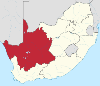
The Northern Cape is the largest and most sparsely populated province of South Africa. It was created in 1994 when the Cape Province was split up. Its capital is Kimberley. It includes the Kalahari Gemsbok National Park, part of the Kgalagadi Transfrontier Park and an international park shared with Botswana. It also includes the Augrabies Falls and the diamond mining regions in Kimberley and Alexander Bay.

Namaqualand is an arid region of Namibia and South Africa, extending along the west coast over 1,000 km (600 mi) and covering a total area of 440,000 km2 (170,000 sq mi). It is divided by the lower course of the Orange River into two portions – Little Namaqualand to the south and Great Namaqualand to the north.

The Karoo is a semi-desert natural region of South Africa. No exact definition of what constitutes the Karoo is available, so its extent is also not precisely defined. The Karoo is partly defined by its topography, geology and climate, and above all, its low rainfall, arid air, cloudless skies, and extremes of heat and cold. The Karoo also hosted a well-preserved ecosystem hundreds of million years ago which is now represented by many fossils.

The West Coast District Municipality is a district municipality located in the Western Cape province of South Africa. Its municipality code is DC1. Moorreesburg is the seat of the district. As of 2011, it had a total population of 391,766.

Matzikama Municipality is a local municipality which governs the northernmost part of the Western Cape province of South Africa, including the towns of Vredendal, Vanrhynsdorp, Klawer and Lutzville, and the surrounding villages and rural areas. As of 2011, it had a population of 67,147. It forms part of the West Coast District Municipality, and its municipality code is WC011.

Tankwa Karoo National Park is a national park in South Africa. The park lies about 70 km west of Sutherland and along the border of the Northern Cape and Western Cape in Succulent Karoo habitat; a biodiversity hotspot and one of the most arid regions of South Africa.

Gonialoe variegata, also known as tiger aloe and partridge-breasted aloe, is a species of flowering plant in the family Asphodelaceae. It is an evergreen succulent perennial indigenous to South Africa and Namibia. It is common in cultivation.

Kamiesberg Municipality is a local municipality within the Namakwa District Municipality, in the Northern Cape province of South Africa.

The Karoo National Park is a wildlife reserve in the Great Karoo area of the Western Cape, South Africa near Beaufort West. This semi-desert area covers an area of 750 square kilometres (290 sq mi). The Nuweveld portion of the Great Escarpment runs through the Park. It is therefore partly in the Lower Karoo, at about 850 m above sea level, and partly in the Upper Karoo at over 1300 m altitude.

Springbok is the largest town in the Namaqualand area in the Northern Cape province of South Africa. It was called Springbokfontein until 1911, when it was shortened to Springbok. Springbok is located on the N7 national route which connects the Cape with Namibia, and at the western end of the N14, which connects it with Upington and Pretoria. It is the main town of the Nama Khoi Local Municipality, which also includes a number of surrounding towns such as Okiep and Nababeep.

The Richtersveld is a desert landscape characterised by rugged kloofs and high mountains, situated in the north-western corner of South Africa’s Northern Cape province. It is full of changing scenery from flat, sandy, coastal plains, to craggy sharp mountains of volcanic rock and the lushness of the Orange River, which forms the border with neighboring Namibia. The area ranges in altitude from sea level, to 1,377 m (4,518 ft) at Cornellberg. Located in the north-western side of the Northern Cape province in South Africa, the Richtersveld is regarded as the only arid biodiversity hotspot on earth and the majority of the area is inscribed on UNESCO's World Heritage List due to its cultural values.

The wildlife of South Africa consists of the flora and fauna of this country in Southern Africa. The country has a range of different habitat types and an ecologically rich and diverse wildlife, vascular plants being particularly abundant, many of them endemic to the country. There are few forested areas, much savanna grassland, semi-arid Karoo vegetation and the fynbos of the Cape Floristic Region. Famed for its national parks and big game, 297 species of mammal have been recorded in South Africa, as well as 849 species of bird and over 20,000 species of vascular plants.

Namaqua National Park is a South African national park situated on the edge of the Atlantic coast of Namaqualand. This biome is a biodiversity hotspot with the largest concentration of succulent plants in the world. The park also has an arid environment with succulent plants. The park was created to protect its endemic flowers. During the spring, wildflowers bloom there in a spectacular fashion. The park's main tourist attraction is this abundant spring bloom of brightly coloured wildflowers.

The Western Cape Division of the High Court of South Africa is a superior court of law with general jurisdiction over the Western Cape province of South Africa. The division, which sits at Cape Town, consists of 31 judges led by Acting Judge President Patricia Goliath, former Acting Constitutional Court Justice.

The Kamiesberg or Kamiesberge, is a mountain range of jumbled granite inselbergs or bornhardts dotted over sandy plains and centered on Kamieskroon in Namaqualand in South Africa. This range is very like the Matopos of Zimbabwe in appearance. It stretches for about 140 km (60 mi) from Garies in the south to Springbok in the north and forms a plateau between the Sandveld of the Cape West Coast and Bushmanland in the east, with the Hardveld of the mountainous central Kamiesberg escarpment in the midst.
The Knersvlakte Nature Reserve is a nature reserve in the Knersvlakte region of South Africa's Western Cape province. It covers an area of 855 square kilometres (330 sq mi) in the Matzikama Municipality, north of Vredendal and Vanrhynsdorp. The reserve, which was established on 24 September 2014, is owned by the South African branch of the World Wide Fund for Nature and managed by provincial conservation agency CapeNature.

The Goegap Nature Reserve is a semi-desert nature reserve in Northern Cape, South Africa and lies around 8 km (5.0 mi) east of Springbok. The area was once used to graze livestock and was proclaimed in 1966 as a reserve then fenced in 1969 and wildlife introduced shortly afterward. It was originally known as the Hester Malan Nature Reserve.

Euphorbia tuberosa, commonly known as '"milkball/melkbol"' or '"wilderamenas"', is a variable geophytic plant of the family Euphorbiaceae, indigenous to the western parts of South Africa.


