
The West Coast District Municipality is a district municipality located in the Western Cape province of South Africa. Its municipality code is DC1. Moorreesburg is the seat of the district. As of 2011 it had a total population of 391,766.
Swartland Municipality is a municipality located in the Western Cape Province of South Africa. Malmesbury is the seat of the municipality. As of 2016, it had a population of 133,762. Its municipality code is WC015.

The Cape Floristic Region is a floristic region located near the southern tip of South Africa. It is the only floristic region of the Cape Floristic Kingdom, and includes only one floristic province, known as the Cape Floristic Province.
Malmesbury is a town of approximately 36,000 inhabitants in the Western Cape province of South Africa, about 65 km north of Cape Town.

The Swartland is a region of Western Cape Province that begins some 50 kilometres (31 mi) north of Cape Town and consists of the area between the towns of Malmesbury in the south, Darling in the west, Piketberg in the north, Moorreesburg in the middle and the Riebeek West and Riebeek Kasteel in the east. Jan van Riebeeck called this softly undulating country between the mountain ranges "Het Zwarte Land" because of the endemic Renosterbos. After the rains, mainly in winter, the Renosterbos takes on a dark appearance when viewed from the distance in large numbers. This is due to the fine leaf-hairs adhering to the leaves when wet. The wide fertile plain is the bread basket of Cape Town with its wheat fields reaching up to the foot of the mountains, interrupted by wine, fruit, and vegetable farms. In Moorreesburg can be found only one of two museums in the world that shows the history of wheat farming.

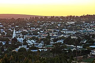
Moorreesburg is a rural town situated about 90 kilometres (60 mi) north of Cape Town, in the Western Cape province of South Africa. It was laid out in 1879 on the farm Hooikraal, was administered by a village management board from 1882 and attained municipal status in 1909. Today it falls within the Swartland Local Municipality, which is part of the West Coast District Municipality. The town is the seat of government for the West Coast District Municipality.

Riebeek-Kasteel is one of the oldest towns in South Africa, situated at 80 km north-east of Cape Town in The Riebeek Valley together with its sister town Riebeek West. They set off in the direction of Paardeberg and on 3 February 1661 they ascended a lonely mountain and came upon the fertile vista of the Riebeek Valley. They named it Riebeek Kasteel, in honor of the Commander.
Wolseley is a small town in the upper Breede River Valley region of the Western Cape province of South Africa. In the 2011 Census it had a population of 1,528 people. It is located 90 kilometres (60 mi) northeast of Cape Town, in the Land van Waveren valley between the Waterval Mountains to the west and the Witzenberg Mountains to the east.
Swartland Alluvium Fynbos is a critically endangered vegetation type that occurs on the high plains and mountains in the far south-west of the Western Cape, South Africa.

Swartland Shale Renosterveld is a critically endangered vegetation type of the Western Cape, South Africa.

Tygerberg Nature Reserve is a 300-hectare (740-acre) nature reserve on the Tygerberg Hills in the northern suburbs of Cape Town, South Africa.

Uitkamp Wetland Nature Reserve is a 32-hectare (79-acre) wetland reserve located in Durbanville in the Western Cape province of South Africa.

Bracken Nature Reserve is a 36-hectare (89-acre) piece of protected land in Brackenfell in the Western Cape, South Africa.

Durbanville Nature Reserve is a 6-hectare (15-acre) piece of protected land, located next to the Durbanville Racecourse in the Western Cape, South Africa.

The South African Railways Class NG9 4-6-0 of 1915 was a narrow-gauge steam locomotive.

The Boland is a region of the Western Cape province of South Africa, situated to the northeast of Cape Town in the middle and upper courses of the Berg and Breede Rivers, around the Boland Mountains of the central Cape Fold Belt. It is sometimes also referred to as the Cape Winelands because it is the primary region for the making of Western Cape wine.

Western Province Command was a command of the South African Army.

Chris Hunsinger is a South African politician, a Member of the South African Parliament since 2014, Caucus Whip and Treasurer with the Democratic Alliance. He was appointed by the then Leader of the Opposition Mmusi Maimane on 5 June 2019 and retained by the current Leader of the Opposition John Steenhuisen in October 2019 and again in December 2020, as The Shadow Minister of Transport. Hunsinger was re-elected to Parliament on 6 June 2019. He speaks and writes about issues related to consumer and commodity needs in transport, including safety, planning, finance and management with South African road, rail, maritime, and aviation service providers.
Johannes Willem du Toit is a South African rugby union player for the Stormers in Super Rugby and Western Province in the Currie Cup and in the Rugby Challenge. He can play as a flanker or a lock.

Protea odorata is a small, sparsely branched, unisexual evergreen shrub that grows up to 1.5 metres tall. It has light green branches that turn brown with age and produce leaves that are upward or arched like leaves. The leaves are hairless and have a curved back and tips that can easily hurt the hand when touched. The leaves become black with age and the spines are pink or reddish in young years, but turn brown and brown with age.


