
French cuisine consists of the cooking traditions and practices from France.

A campfire is a fire at a campsite that provides light and warmth, and heat for cooking. It can also serve as a beacon, and an insect and predator deterrent. Established campgrounds often provide a stone or steel fire ring for safety. Campfires are a popular feature of camping. At summer camps, the word campfire often refers to an event at which there is a fire. Some camps refer to the fire itself as a campfire.

Wiluna is a town in the Mid West region of Western Australia. It is situated on the edge of the Western Desert at the gateway to the Canning Stock Route and Gunbarrel Highway. It is the service centre of the local area for the local Aboriginal people, the pastoral industry, the Wiluna Gold Mine, and many more people who work on other mines in the area on a "fly-in/fly-out" basis. Wiluna's climate is hot and dry, with an annual rainfall of 254 mm (10 in). Mean maximum temperatures range from 19 °C (66 °F) in July, to 38 °C (100 °F) in January.
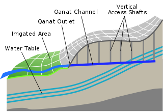
A qanat or kariz is a gently sloping underground channel to transport water from an aquifer or water well to surface for irrigation and drinking, acting as an underground aqueduct. This is an old system of water supply from a deep well with a series of vertical access shafts. The qanats still create a reliable supply of water for human settlements and irrigation in hot, arid, and semi-arid climates, but the value of this system is directly related to the quality, volume, and regularity of the water flow. Traditionally qanats are built by a group of skilled laborers, muqannīs, with hand labor. The profession historically paid well and was typically handed down from father to son. According to most sources, the qanat technology was developed in ancient Iran by the Persian people sometime in the early 1st millennium BCE, and spread from there slowly westward and eastward. However, some other sources suggest a Southeast Arabian origin.

Pelotas is a Brazilian city and municipality (município), the third most populous in the southern state of Rio Grande do Sul. Pelotas is located 270 km (168 mi) from Porto Alegre, the capital city of the state, and 130 km (80.8 mi) from the Uruguayan border. The Lagoa dos Patos lies to the east and the São Gonçalo Channel lies to the south, separating Pelotas from the city of Rio Grande.
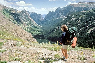
Backpacking is the outdoor recreation of carrying gear on one's back, while hiking for more than a day. It is often but not always an extended journey, and may or may not involve camping outdoors. In North America tenting is common, where simple shelters and mountain huts widely found in Europe are rare. In New Zealand, tramping is the term applied though overnight huts are frequently used. Hill walking is an equivalent in Britain, though backpackers make use of all kinds of accommodation, in addition to camping. Backpackers use simple huts in South Africa. Trekking and bushwalking are other word used to describe such multi-day trips.

A trullo is a traditional Apulian dry stone hut with a conical roof. Their style of construction is specific to the Itria Valley, in the Murge area of the Italian region of Apulia. Trulli were generally constructed as temporary field shelters and storehouses or as permanent dwellings by small proprietors or agricultural labourers. In the town of Alberobello, in the province of Bari, whole districts contain dense concentrations of trulli. The golden age of trulli was the nineteenth century, especially its final decades, which were marked by the development of wine growing.
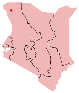
Kakuma is a town in northwestern Turkana County, Kenya. It is the site of a UNHCR refugee camp, established in 1992. The population of Kakuma town was 60,000 in 2014, having grown from around 8,000 in 1990. In 1991, the camp was established to host unaccompanied minors who had fled the war in Sudan and from camps in Ethiopia.

Merredin is a town in Western Australia, located in the central Wheatbelt roughly midway between Perth and Kalgoorlie, on Route 94, Great Eastern Highway. It is located on the route of the Goldfields Water Supply Scheme, and as a result is also on the Golden Pipeline Heritage Trail.

Pemberton is a town in the South West region of Western Australia, named after original settler Pemberton Walcott.

Laingsburg is a town located in the Western Cape province in South Africa. It is a relatively large agricultural town in the semi-arid Great Karoo. It was partially destroyed in a flash flood in 1981.

Ibotirama is a municipality located in the west of the state of Bahia, Brazil. It is in the micro-region of the lower-middle São Francisco River. This major river passes by the city where it is crossed by a recently constructed bridge. Ibotirama covers 1,740.087 km2 (671.851 sq mi), and has a population of 27,405 with a population density of 16 inhabitants per square kilometer. The municipality lies along the São Francisco River, a major inland water route and the fourth-longest river in Brazil.

Ultralight backpacking is a style of backpacking that emphasizes carrying the lightest and simplest gear safely possible for a given trip. Base weight is reduced as much as safely possible, though reduction of the weight of consumables is also applied.
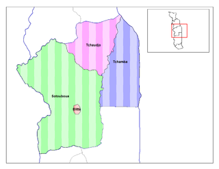
Blitta is a prefecture and town located in the Centrale Region of Togo. Blitta has an area of 2,973 miles and there is roughly 200 or more villages in the area.
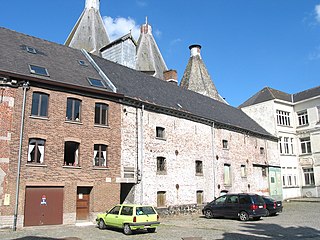
A malt house, malt barn, or maltings, is a building where cereal grain is converted into malt by soaking it in water, allowing it to sprout and then drying it to stop further growth. The malt is used in brewing beer, whisky and in certain foods. The traditional malt house was largely phased out during the twentieth century in favour of more mechanised production. Many malt houses have been converted to other uses, such as Snape Maltings which is now a concert hall.

Boca is a former settlement in Nevada County, California. Situated at an elevation of 5,528 ft (1,685 m) above sea level, Boca is located on the Southern Pacific Railroad, 6.5 miles (10.5 km) northeast of Truckee.

Saint Catherine is a city in the South Sinai Governorate. It is located at the outskirts of the El Tur Mountains at an elevation of 1,586 m (5,203 ft), 120 km (75 mi) away from Nuweiba, at the foot of Mount Sinai and Saint Catherine's Monastery. In 1994, its population was 4,603. Saint Catherine is a UNESCO world heritage site, officially declared in 2002.

Builsa South is one of the constituencies represented in the Parliament of Ghana. It elects one Member of Parliament (MP) by the first past the post system of election. Builsa South is located in the Builsa district of the Upper East Region of Ghana.
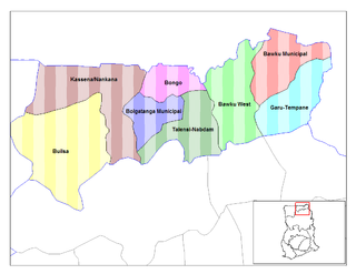
The Kassena-Nankana West is one of the 13 districts in the Upper East Region of north Ghana. The capital is Paga. The district was created in 2008.

Vleesbaai, a seaside vacation town, situated between Mossel Bay and Gouritsmond in Western Cape, South Africa.


