
Johan Anthoniszoon "Jan" van Riebeeck was a Dutch navigator, ambassador and colonial administrator of the Dutch East India Company.

Daniël François Malan was a South African politician who served as the fourth prime minister of South Africa from 1948 to 1954. The National Party implemented the system of apartheid, which enforced racial segregation laws, during his tenure as prime minister.

Paarl is a town with 285,574 inhabitants in the Western Cape province of South Africa. It is the largest town in the Cape Winelands. Due to the growth of the Mbekweni township, it is now a de facto urban unit with Wellington. It is situated about 60 kilometres (37 mi) northeast of Cape Town in the Western Cape Province and is known for its scenic environment and viticulture and fruit-growing heritage.

Stellenbosch is a town in the Western Cape province of South Africa, situated about 50 kilometres east of Cape Town, along the banks of the Eerste River at the foot of the Stellenbosch Mountain. The town became known as the City of Oaks or Eikestad in Afrikaans and Dutch due to the large number of oak trees that were planted by its founder, Simon van der Stel, to grace the streets and homesteads.

The Afrikaner Broederbond (AB) or simply the Broederbond was an exclusively Afrikaner Calvinist and male secret society in South Africa dedicated to the advancement of the Afrikaner people. It was founded by H. J. Klopper, H. W. van der Merwe, D. H. C. du Plessis and the Rev. Jozua Naudé in 1918 as Jong Zuid Afrika until 1920, when it was renamed the Broederbond. Its influence within South African political and social life came to a climax with the 1948-1994 rule of the white supremacist National Party and its policy of apartheid, which was largely developed and implemented by Broederbond members. Between 1948 and 1994, many prominent figures of Afrikaner political, cultural, and religious life, including every leader of the South African government, were members of the Afrikaner Broederbond.
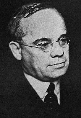
Jan Hendrik Hofmeyr was a South African politician and intellectual in the years preceding apartheid. In his lifetime he was regarded as one of the cleverest men in the country, and it was widely expected that he would eventually become Prime Minister of South Africa. He came from a well-known Afrikaner family; his uncle, also Jan Hendrik Hofmeyr but known affectionately as "Onze Jan" among fellow Afrikaners, was a famous figure in the Afrikaans language movement.
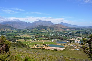
Franschhoek is a small town in the Western Cape Province and one of the oldest towns in South Africa. It was formerly known as Oliphants hoek. It is situated about 75 kilometres (47 mi) from Cape Town, a 45-minute drive away. The whole area, including townships such as Groendal and suburbs such as Wemmershoek, has a population of slightly over 20,000 people while the town proper, known as Hugenote, has a population of around 1,000. Since 2000, it has been incorporated into Stellenbosch Municipality. In 2022, Franschhoek was mentioned in Time magazine as one of the top 50 places in the world to visit.
Swartland Municipality is a local municipality located in the Western Cape province of South Africa. Malmesbury is the seat of the municipality. As of 2022, it had a population of 148,331. Its municipality code is WC015.

Jan Christian Smuts, OM, CH, ED, KC, FRS was a prominent South African and Commonwealth statesman, military leader, and philosopher. He served as a Boer General during the Boer War, a British General during the First World War and was appointed Field Marshal by King George VI during the Second World War. In addition to various cabinet appointments, he served as Prime Minister of the Union of South Africa from 1919 until 1924 and from 1939 until 1948. From 1917 to 1919 he was one of five members of the British War Cabinet, helping to create the Royal Air Force. He played a leading part in the post-war settlements at the end of both world wars, making significant contributions towards the creation of the League of Nations and the United Nations. He did much to redefine the relationship between Britain and the Dominions and Colonies, leading to the formation of the British Commonwealth.

The Swartland is a region of Western Cape Province that begins some 50 kilometres (31 mi) north of Cape Town and consists of the area between the towns of Malmesbury in the south, Darling in the west, Piketberg in the north, Moorreesburg in the middle and the Riebeek West and Riebeek Kasteel in the east. Jan van Riebeeck called this softly undulating country between the mountain ranges "Het Zwarte Land" because of the endemic Renosterbos. After the rains, mainly in winter, the Renosterbos takes on a dark appearance when viewed from the distance in large numbers. This is due to the fine leaf-hairs adhering to the leaves when wet. The wide fertile plain is the bread basket of Cape Town with its wheat fields reaching up to the foot of the mountains, interrupted by wine, fruit, and vegetable farms. In Moorreesburg can be found only one of two museums in the world that shows the history of wheat farming.

The "!Oroǀõas" ("Ward-girl"), spelled in Dutch as Krotoa or Kroket, otherwise known by her Christian name Eva, was a !Uriǁ'aeǀona translator who worked for the Vereenigde Oostindische Compagnie (VOC) during the founding of the Cape Colony.

Mahlamba Ndlopfu is the chief official residence of the President of the Republic of South Africa. The head of government has made it their official home since 1940 and it is located in the Bryntirion Estate in Pretoria.

Many people of European heritage in South Africa are descended from Huguenots. Most of these originally settled in the Cape Colony, but were absorbed into the Afrikaner and Afrikaans-speaking population, because they had religious similarities to the Dutch colonists.

Riebeek-Kasteel is one of the oldest towns in South Africa, situated at 80 km north-east of Cape Town in The Riebeek Valley together with its sister town Riebeek West. They set off in the direction of Paardeberg and on 3 February 1661 they ascended a lonely mountain and came upon the fertile vista of the Riebeek Valley. They named it Riebeek Kasteel, in honor of the Commander.

The Royal Hotel in Riebeek Kasteel is the oldest licensed hotel of the Western Cape and was built in 1862. This now fully restored heritage building is one of the few hotels left of that particular colonial era of South Africa. Famous visitors in history were Jan Smuts and Daniel Malan, both from the Riebeek Valley and both prime ministers of South Africa during troubled times. In 2006 southafrica.org placed The Royal as only hotel on the list of "the 50 most fabulous places to visit in SA". According to them it has the longest stoep (veranda) south of the Limpopo.

Bothmanskloof Pass is situated in the Western Cape province of South Africa, on the R46 between Malmesbury and Riebeek Kasteel. It is also sometimes called Bothmaskloof.
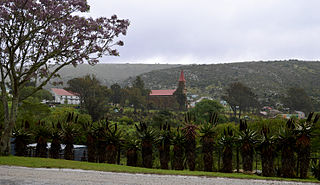
Riebeek East is a village in the Eastern Cape province of South Africa, set 39 km west of Grahamstown. It is located in a hilly area, in the midst of game and sheep farming regions. It was founded in 1842, and initially named Riebeek after Jan van Riebeeck, one year after the local church was built. It was erected on a part of the farm Mooimeisjesfontein, that was subdivided and sold by the subsequent voortrekker leader Piet Retief.

Stellenberg is a suburb in Bellville, Western Cape South Africa.

Paul Oliver Sauer was a South African Cabinet Minister and lifelong member of the National Party.
Esterhof is a settlement and housing development in West Coast District Municipality in the Western Cape province of South Africa. Esterhof is located roughly two kilometers to the east of Riebeek-Kasteel, separated by a railway and industrial buildings, and was originally created as part of apartheid initiatives that forcibly displaced Coloured people out of Oukloof in the 1960s.


