
The Eastern Cape is one of the nine provinces of South Africa. Its capital is Bhisho, but its two largest cities are East London and Gqeberha. Due to its climate and nineteenth century towns, it is a common location for tourists. It is also known for being home to many anti-apartheid activists, the most famous being Nelson Mandela hailing from the province.

The Western Cape is a province of South Africa, situated on the south-western coast of the country. It is the fourth largest of the nine provinces with an area of 129,449 square kilometres (49,981 sq mi), and the third most populous, with an estimated 7 million inhabitants in 2020. About two-thirds of these inhabitants live in the metropolitan area of Cape Town, which is also the provincial capital. The Western Cape was created in 1994 from part of the former Cape Province. The two largest cities are Cape Town and George.

Overberg is a region in South Africa to the east of Cape Town beyond the Hottentots-Holland mountains. It lies along the Western Cape Province's south coast between the Cape Peninsula and the region known as the Garden Route in the east. The boundaries of the Overberg are the Hottentots-Holland mountains in the West; the Riviersonderend Mountains, part of the Cape Fold Belt, in the North; the Atlantic and Indian Oceans in the South and the Breede River in the East.

The West Coast District Municipality is a district municipality located in the Western Cape province of South Africa. Its municipality code is DC1. Moorreesburg is the seat of the district. As of 2011, it had a total population of 391,766.

Bergrivier Municipality is a local municipality in the Western Cape province of South Africa. It governs the towns of Piketberg, Velddrif and Porterville, as well as the surrounding villages and rural areas. As of 2011, it had a population of 61,897. It is located within the West Coast District Municipality and its municipality code is WC013.

Matzikama Municipality is a local municipality which governs the northernmost part of the Western Cape province of South Africa, including the towns of Vredendal, Vanrhynsdorp, Klawer and Lutzville, and the surrounding villages and rural areas. As of 2011, it had a population of 67,147. It forms part of the West Coast District Municipality, and its municipality code is WC011.
Swartland Municipality is a local municipality located in the Western Cape province of South Africa. Malmesbury is the seat of the municipality. As of 2016, it had a population of 133,762. Its municipality code is WC015.
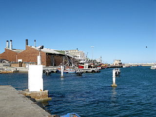
Vredenburg is a town of the Cape West Coast in the Western Cape province of South Africa. "Vrede" is Afrikaans for peace. It is the transportation and commercial hub of the West Coast area and administrative centre of the Saldanha Bay Local Municipality. It is located 12 kilometres inland from the coast at Saldanha Bay on the Cape Columbine Peninsula 138 km north of Cape Town.

Vredendal is a town in the northern Olifants River Valley in the Western Cape province of South Africa, with a population of 16,164 people. It lies 250 kilometres (160 mi) north of Cape Town on the banks of the Olifants River at the southern edge of Little Namaqualand.

Moorreesburg is a rural town situated about 90 kilometres (60 mi) north of Cape Town, in the Western Cape province of South Africa. It was laid out in 1879 on the farm Hooikraal, was administered by a village management board from 1882 and attained municipal status in 1909. Today it falls within the Swartland Local Municipality, which is part of the West Coast District Municipality. The town is the seat of government for the West Coast District Municipality.
The Western Cape province of South Africa is governed in a parliamentary system in which the people elect the Provincial Parliament, and the parliament elects the Premier as head of the executive. The Premier leads a cabinet of provincial ministers overseeing various executive departments. The provincial government is subject to the Constitution of the Western Cape and the Constitution of South Africa, which together form the supreme law of the province.
Lambert's Bay is a small fishing town in the Western Cape province of South Africa situated 280 kilometres (170 mi) north of Cape Town. It is part of the Cederberg Municipality.
The Western Cape Education Department is the department of the Government of the Western Cape responsible for primary and secondary education within the Western Cape province of South Africa. The political leader of the department is the Provincial Minister of Education; as of 2009 this is Donald Grant.

Doringbaai is a settlement in West Coast District Municipality in the Western Cape province of South Africa.

Grotto Bay is a coastal private property in West Coast District Municipality in the Western Cape province of South Africa. It was declared a nature reserve in 2002. Covering about 378,000 hectares is located 45 minutes from Cape Town. "Cape West Coast Biosphere". website. Retrieved 9 January 2023.Grotto Bay forms part of the Cape West Coast Biosphere reserve which was proclaimed by UNESCO in 2000. Incorporating 378 000 hectares, it stretches from the mouth of the Diep River at Milnerton and covers the entire coastal lowlands to far north of the Berg River at Velddrift. There are 459 biospheres globally, 65 of them in Africa and 4 in South Africa. All Biospheres promote a balanced approach to the development of humans and the preservation of biodiversity in a particular region. The aim of the Cape West Coast Biosphere is to foster human development that is ecologically sustainable, conserve the landscape, vegetation and living species. It also support the research, monitoring, education and information exchange related to local, national and global issues of conservation and development.

Hopefield is a settlement in West Coast District Municipality in the Western Cape province of South Africa on the R45 between Malmesbury and Vredenburg. The town lies east of Saldanha Bay and Langebaan, 40 km (25 mi) southeast of Vredenburg and 120 km (75 mi) north of Cape Town.
Bitterfontein is a village in the Knersvlakte, the northernmost area of the Western Cape province of South Africa, 320 kilometres (200 mi) north of Cape Town. It is the railhead of a line from Cape Town; ore from the copper mines at Okiep is transferred there from road transport to the railway. It is also located on the N7 national road; the distance from Cape Town is 386 kilometres (240 mi) by road and 465 kilometres (289 mi) by rail.

The Boland is a region of the Western Cape province of South Africa, situated to the northeast of Cape Town in the middle and upper courses of the Berg and Breede Rivers, around the Boland Mountains of the central Cape Fold Belt. It is sometimes also referred to as the Cape Winelands because it is the primary region for the making of Western Cape wine.
The Cape Winelands Biosphere Reserve is located in the Western Cape Province of South Africa approximately 40 km (25 mi) east of Cape Town. The Biosphere Reserve extends from the Kogelberg Biosphere Reserve in the south, northwards along the Cape Fold Belt Mountain Chain and the adjoining valleys constituting the Cape Winelands. The Biosphere Reserve incorporates key portions of the registered Cape Floral Region Protected Areas World Heritage Site. The Reserve was designated in 2007.


