
Paarl is a town with 285,574 inhabitants in the Western Cape province of South Africa. It is the third-oldest European settlement in the Republic of South Africa and the largest town in the Cape Winelands. Due to the growth of the Mbekweni township, it is now a de facto urban unit with Wellington. It is situated about 60 kilometres (37 mi) northeast of Cape Town in the Western Cape Province and is known for its scenic environment and viticulture and fruit-growing heritage.
Langebaanweg is a town on the southwest coast of South Africa, in Western Cape Province.

Paternoster is one of the oldest fishing villages on the West Coast of South Africa. It is situated 15 km north-west of Vredenburg and 145 km north of Cape Town, at Cape Columbine between Saldanha Bay and St Helena Bay. The town covers an area of 194.8 hectare and has approximately 1883 inhabitants.

The West Coast District Municipality is a district municipality located in the Western Cape province of South Africa. Its municipality code is DC1. Moorreesburg is the seat of the district. As of 2011, it had a total population of 391,766.
Saldanha Bay Municipality is a local municipality located within the West Coast District Municipality, in the Western Cape province of South Africa. As of 2011, it had a population of 99,193. Its municipality code is WC014.

The R27 is a provincial route in South Africa that consists of two disjoint segments. The first segment, also known as the West Coast Highway, connects Cape Town with Velddrif along the West Coast. The second runs from Vredendal via Vanrhynsdorp, Calvinia, Brandvlei and Kenhardt to Keimoes on the N14 near Upington. The connection between Velddrif and Vredendal has never been built, although it can be driven on various gravel roads.

The R45 is a provincial route in Western Cape, South Africa that connects Saldanha with Villiersdorp via Vredenburg, Malmesbury and Paarl. The route is mostly a two-lane wide-shouldered highway, however sections within Paarl and between Vredenburg and Saldanha are dual-carriageways. The R45 is co-signed with the N7 for a short segment north of Malmesbury.
The R399 is a Regional Route in South Africa that connects Vredenburg with the N7 between Piketberg and De Hoek.

Saldanha Bay is a natural harbour on the south-western coast of South Africa. The town that developed on the northern shore of the bay, also called Saldanha, was incorporated with five other towns into the Saldanha Bay Local Municipality in 2000. The current population of the municipality is estimated at 72,000.

Darling is a small town in a farming area on the west coast region of the Western Cape, about 75 km (46.6 mi) from Cape Town.
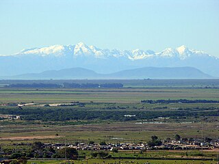
The West Coast is a region of the Western Cape province in South Africa and is bordered by the Atlantic Ocean on the west and the Swartland region on the east.
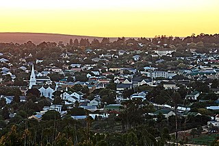
Malmesbury is a town of approximately 36,000 inhabitants in the Western Cape province of South Africa, about 65 km north of Cape Town.
Vredenburg is a town of the Cape West Coast in the Western Cape province of South Africa. "Vrede" is Afrikaans for peace. It is the transportation and commercial hub of the West Coast area and administrative centre of the Saldanha Bay Local Municipality. It is located 12 kilometres inland from the coast at Saldanha Bay on the Cape Columbine Peninsula 138 km north of Cape Town.

The West Coast National Park lies 88 km (55 mi) north of Cape Town in the Western Cape province of South Africa. The park is found inside of the Cape West Coast Biosphere Reserve, part of the UNESCO Man and the Biosphere Programme. It is bordered by the Atlantic Ocean on the west and the R27 coastal road, and runs from the town of Yzerfontein in the south, up to the Langebaan Lagoon. The park is particularly well known for its bird life and for the spring flowers which occur in the months from August to September, especially in the Postberg flower reserve section of the park. The park, with the islands in Saldanha Bay, has been identified by BirdLife International as an Important Bird Area. The park was proclaimed in 1985, and is 36,259.8 hectares (140.000 sq mi) in size.

Langebaan is a town in the Western Cape province of South Africa on the eastern shore of Langebaan Lagoon.

The West Coast Fossil Park is a fossil park near Langebaanweg, Western Cape, South Africa, approximately 150 kilometres (93 mi) north of Cape Town. The fossil sites of Langebaanweg have exceptionally well-preserved remains of fossil fauna that date to circa 5.2 million years ago. In this period, sea levels were higher and many now extinct animals lived in the riverine forests, wooded savanna and along the sea coast near the present day Langebaanweg site. Phosphate mining operations at Langebaanweg uncovered these rich fossil deposits. The fossils include bones of over 200 different animal species. This represents possibly the greatest diversity of five-million-year-old fossils found anywhere in the world. The fossil park was formed after mining operations ceased in 1993. The park is partnered with the Iziko South African Museum.
The South African Railways Class NG7 2-6-0 of 1902 was a narrow gauge steam locomotive from the pre-Union era in the Cape of Good Hope.
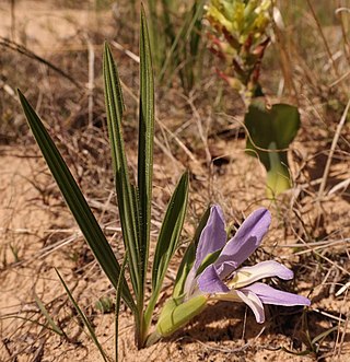
Babiana nana is a species of geophyte of 6–15 cm (2.4–5.9 in) high that is assigned to the family Iridaceae. It has leaves that consist of a sheath and a blade that are at an angle with each other. The leaf blades are oval to almost line-shaped and have a left and right surface, rather than an upper and lower surface. The leaf blades are moderately pleated and covered in dense, soft hairs. The inflorescence contains two to six blue to violet or pale pink flowers adorned with white markings on the lower lip, and with three stamens crowding under the upper lip. Flowering occurs from late August to the end of September. The flowers emit a smell reminiscent of roses or violets.

The Hopefield Reformed Church is a congregation of the Dutch Reformed Church in the South African province of Western Cape. The center of gravity of the parish is the Sandveld town of Hopefield. It separated from the Swartland Reformed Church on 13 December 1851 as the 48th congregation in the then Cape Church. In 1902 Vredenburg seceded from Hopefield, in 1957 Saldanha/Langebaan Road and in 1988 Langebaan.


