Matzikama Local Municipality

Last updated

Matzikama
Matzikama CoA.png
Map of the Western Cape with Matzikama highlighted (2011).svg
Location in the Western Cape
Matzikama LM topographic map.svg
Topographic map
Coordinates: 31°15′S18°30′E / 31.250°S 18.500°E / -31.250; 18.500
Country South Africa
Province Western Cape
District West Coast
Seat Vredendal
Wards 8
Government
  Type Municipal council
  MayorMr. J. Van Der Hoven (DA)
Area
  Total12,981 km2 (5,012 sq mi)
Population
 (2011) [1]
  Total67,147
  Density5.2/km2 (13/sq mi)
Racial makeup (2011)
[1]
   Black African 8.5%
   Coloured 74.7%
   Indian/Asian 0.6%
   White 14.8%
First languages (2011)
[1]
   Afrikaans 91.8%
   Xhosa 3.5%
   English 1.8%
  Other2.9%
Time zone UTC+2 (SAST)
Municipal codeWC011
Website www.matzikamamunicipality.co.za#/home

Matzikama Municipality (Afrikaans : Matzikama Munisipaliteit) is a local municipality which governs the northernmost part of the Western Cape province of South Africa, including the towns of Vredendal, Vanrhynsdorp, Klawer and Lutzville, and the surrounding villages and rural areas. As of 2011, it had a population of 67,147. [1] It forms part of the West Coast District Municipality, and its municipality code is WC011.

Contents

Matzikama is of Khoekhoe origin, the first people of South Africa. It contains the Khoekhoe language words ma which means "give", tsî which means "you", and ǁgamma which means "water", and loosely translates into "you that give water". [2]

Geography

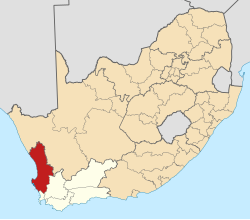
The municipality covers a total area of 12,981 square kilometres (5,012 sq mi) in the northernmost part of the Western Cape province, stretching from the Atlantic Ocean in the west to the mountains of the Bokkeveld Escarpment in the east. The Olifants River flows through the southern part of the municipal area, while to the north lies the hilly area known as the Knersvlakte. The municipality abuts on the Kamiesberg Municipality to the north, the Hantam Municipality to the east and the Cederberg Municipality to the south.

At the 2011 census, the municipality had a population of 67,147 people in 18,835 households. Of this population, 74.7% describe themselves as "Coloured", 14.8% as "White", and 8.5% as "Black African". The first language of 91.8% of the population is Afrikaans, while 3.5% speak Xhosa and 1.8% speak English. [3]

The principal town and seat of the council is Vredendal, which is situated in the valley of the Olifants River and has a population (according to the 2011 census) of 18,170. Other large towns in the municipality are Klawer (pop. 6,234) situated upstream from Vredendal, Lutzville (pop. 5,232) situated downstream from Vredendal, and Vanrhynsdorp (pop. 6,272) to the north-east towards the escarpment. In the Olifants River valley there are also smaller agricultural settlements at Ebenhaeser (pop. 1,305) and Koekenaap (pop. 1,551). South of the mouth of the Olifants River are the coastal villages of Doringbaai (pop. 1,260) and Strandfontein (pop. 431). The villages of Bitterfontein (pop. 986), Kliprand (pop. 205), Nuwerus (pop. 650) and Rietpoort (pop. 970) are situated in the sparsely-populated Knersvlakte in the northern part of the municipality.

History

At the end of the apartheid era, in the area that is today Matzikama, there were municipal councils for the towns of Vredendal, Klawer, Lutzville, Vanrhynsdorp and Bitterfontein, and a local council for the villages of Doringbaai and Strandfontein known as the Louis Rood Local Council. These councils were elected by the white residents. The coloured residents of Vredendal, Klawer, Lutzville, Vanrhynsdorp, Koekenaap, Bitterfontein and Nuwerus were governed by management committees subordinate to the white councils. The former mission stations of Ebenhaeser and Rietpoort were governed by management boards, and the remaining rural areas fell under the West Coast Regional Services Council.

While the negotiations to end apartheid were taking place a process was established for local authorities to negotiate voluntary mergers. Several towns in the Matzikama region took part in this process, resulting in each municipal council merging with its corresponding management committee: Klawer in September 1992, Vanrhynsdorp in December 1992, Vredendal in January 1993, and Lutzville in January 1994.

After the national elections of 1994 a process of local government transformation began, in which negotiations were held between the existing local authorities, political parties, and local community organisations. As a result of these negotiations, the existing local authorities were dissolved and transitional local councils (TLCs) were created for each town and village. In total eight TLCs were created.

The transitional councils were initially made up of members nominated by the various parties to the negotiations, until May 1996 when elections were held. At these elections the West Coast District Council was established, replacing the West Coast Regional Services Council. Transitional representative councils (TRCs) were also elected to represent rural areas outside the TLCs on the District Council; the area that was to become Matzikama was covered by the Vredendal and Vanrhynsdorp TRCs.

At the local elections of December 2000 the TLCs and TRCs were dissolved. The Matzikama Municipality was established, though in 2000 it incorporated only the southern half of the area it governs today. That area included Vredendal, Vanrhynsdorp, Klawer, Lutzville, Ebenhaeser and Doringbaai/Strandfontein. The sparsely populated northern area, including Bitterfontein/Nuwerus and Rietpoort, became a District Management Area of the West Coast District Municipality. In 2011 this area was incorporated into the Matzikama Municipality when District Management Areas were abolished.

Politics

The municipal council consists of fifteen members elected by mixed-member proportional representation. Eight councillors are elected by first-past-the-post voting in eight wards, while the remaining seven are chosen from party lists so that the total number of party representatives is proportional to the number of votes received. In the election of 1 November 2021 the Democratic Alliance (DA) won a plurality of seats on the council.

The following table shows the results of the 2021 election. [4] [5] [6]

Matzikama local election, 1 November 2021
PartyVotesSeats
WardListTotal %WardListTotal
Democratic Alliance 6,1996,25412,45337.3%336
African National Congress 4,8774,8549,73129.1%404
Patriotic Alliance 2,3071,8714,17812.5%112
Good 1,3241,3282,6527.9%011
Freedom Front Plus 1,3031,1892,4927.5%011
Economic Freedom Fighters 6456271,2723.8%011
Independent candidates 48480.1%00
4 other parties1753825571.7%000
Total16,87816,50533,3838715
Valid votes16,87816,50533,38398.7%
Spoilt votes 2232164391.3%
Total votes cast17,10116,72133,822
Voter turnout17,131
Registered voters31,765
Turnout percentage53.9%

In August 2020, the Hawks began investigating corruption in the municipality. [7] [8]

In August 2021, the Matzikama Local Municipality was flagged as one of the four Western Cape municipalities owing millions of rands to Eskom [9]

By-elections from November 2021

The following by-elections were held to fill vacant ward seats in the period since November 2021.

DateWardParty of the previous councillorParty of the newly elected councillor
6 July 2022 [10] 7 Patriotic Alliance Democratic Alliance

After the by-election, the council was reconfigured as below:

PartySeats
WardListTotal
Democratic Alliance 437
African National Congress 404
Patriotic Alliance 011
Good 011
Freedom Front Plus 011
Economic Freedom Fighters 011
Total8715

Related Research Articles

<span class="mw-page-title-main">George Local Municipality</span> Local municipality in Western Cape, South Africa

George Municipality is a local municipality within the Garden Route District Municipality, in the Western Cape province of South Africa. As of 2011, the population is 193,672. Its municipality code is WC044.

<span class="mw-page-title-main">Mossel Bay Local Municipality</span> Local municipality in Western Cape, South Africa

Mossel Bay Municipality is a local municipality within the Garden Route District Municipality, in the Western Cape province of South Africa. As of 2011, the population was 89,430.

<span class="mw-page-title-main">Langeberg Local Municipality</span> Local municipality in Western Cape, South Africa

Langeberg Municipality, known before 28 August 2009 as Breede River/Winelands Municipality, is a local municipality located within the Cape Winelands District Municipality, in the Western Cape province of South Africa. As of 2011, it had a population of 97,724. Its municipality code is WC026.

<span class="mw-page-title-main">Beaufort West Local Municipality</span> Local municipality in Western Cape, South Africa

Beaufort West Municipality is a local municipality located in the Western Cape province of South Africa. As of 2011, the population is 49,586. Its municipality code is WC053.

<span class="mw-page-title-main">Oudtshoorn Local Municipality</span> Local municipality in Western Cape, South Africa

Oudtshoorn Municipality is a local municipality within the Garden Route District Municipality, in the Western Cape province of South Africa. As of 2011, the population was 95,933.

<span class="mw-page-title-main">Overstrand Local Municipality</span> Local municipality in Western Cape, South Africa

Overstrand Municipality is a local municipality in the Western Cape province of South Africa. It is located along the Atlantic coast between Cape Town and Cape Agulhas, within the Overberg District Municipality. The principal towns in the municipality are Hermanus, Gansbaai and Kleinmond. As of 2011, it had a population of 80,432.

<span class="mw-page-title-main">Prince Albert Local Municipality</span> Local municipality in Western Cape, South Africa

Prince Albert Municipality is a local municipality located in the Western Cape province of South Africa.

<span class="mw-page-title-main">Drakenstein Local Municipality</span> Local municipality in Western Cape, South Africa

Drakenstein Municipality is a local municipality located within the Cape Winelands District Municipality, in the Western Cape province of South Africa. As of 2011, it had a population of 251,262. Its municipality code is WC023.

<span class="mw-page-title-main">Bergrivier Local Municipality</span> Local municipality in Western Cape, South Africa

Bergrivier Municipality is a local municipality in the Western Cape province of South Africa. It governs the towns of Piketberg, Velddrif and Porterville, as well as the surrounding villages and rural areas. As of 2011, it had a population of 61,897. It is located within the West Coast District Municipality and its municipality code is WC013.

<span class="mw-page-title-main">Breede Valley Local Municipality</span> Local municipality in Western Cape, South Africa

Breede Valley Municipality is a local municipality located within the Cape Winelands District Municipality, in the Western Cape province of South Africa. As of 2007, it had a population of 166,825. Its municipality code is WC025.

<span class="mw-page-title-main">Cape Agulhas Local Municipality</span> Local municipality in Western Cape, South Africa

Cape Agulhas Municipality is a municipality located in the Western Cape province of South Africa. As of 2011, it had a population of 33,038. Its municipality code is WC033. It is named after Cape Agulhas, the southernmost point of Africa. The largest town is Bredasdorp, which is the seat of the municipal headquarters. It also includes the villages of Napier, Struisbaai, Elim, Arniston and L'Agulhas, and the De Hoop Nature Reserve.

<span class="mw-page-title-main">Cederberg Local Municipality</span> Local municipality in Western Cape, South Africa

Cederberg Municipality is a local municipality which governs an area of the Western Cape province of South Africa stretching from the Cederberg mountains through the middle valley of the Olifants River to the Atlantic coast. It includes the towns of Clanwilliam, Citrusdal and Lamberts Bay, and the surrounding villages and farms. As of 2011 it had a population of 49,768. It is located within the West Coast District Municipality and its municipality code is WC012.

<span class="mw-page-title-main">Kannaland Local Municipality</span> Local municipality in Western Cape, South Africa

Kannaland Municipality is a local municipality located within the Garden Route District Municipality, in the Western Cape province of South Africa. The municipal area is situated in the western part of the Little Karoo and includes the towns of Ladismith, Calitzdorp and Zoar. As of 2011, it has a population of 24,767. Its municipality code is WC041.

<span class="mw-page-title-main">Hessequa Local Municipality</span> Local municipality in Western Cape, South Africa

Hessequa Municipality, known before 24 June 2005 as Langeberg Municipality, is a local municipality within the Garden Route District Municipality, in the Western Cape province of South Africa. It is flanked by the lower Breede River to the west and the Gourits River to the east. As of 2011, the population was 52,642. Its municipality code is WC042. The name Hessequa, meaning "people of the trees", refers to the indigenous Khoikhoi people.

<span class="mw-page-title-main">Swellendam Local Municipality</span> Local municipality in Western Cape, South Africa

Swellendam Municipality is a local municipality located within the Overberg District Municipality, in the Western Cape province of South Africa. As of 2011, it had a population of 35,916. Its municipality code is WC034.

<span class="mw-page-title-main">Theewaterskloof Local Municipality</span> Local municipality in Western Cape, South Africa

Theewaterskloof Municipality is a local municipality located within the Overberg District Municipality, in the Western Cape province of South Africa. As of 2007, the population was 108,790. Its municipality code is WC031. The enormous Theewaterskloof Dam, which provides water for Cape Town and the surrounding areas, is located in this municipality.

<span class="mw-page-title-main">Vredendal</span> Place in Western Cape, South Africa

Vredendal is a town in the northern Olifants River Valley in the Western Cape province of South Africa, with a population of 16,164 people. It lies 250 kilometres (160 mi) north of Cape Town on the banks of the Olifants River at the southern edge of Little Namaqualand.

<span class="mw-page-title-main">Thembelihle Local Municipality</span> Local municipality in Northern Cape, South Africa

Thembelihle Municipality, formerly known as Oranje-Karoo Municipality, is a local municipality within the Pixley ka Seme District Municipality, in the Northern Cape province of South Africa. Thembelihle is a Xhosa word meaning "good hope".

<span class="mw-page-title-main">Klawer</span> Place in Western Cape, South Africa

Klawer is a town in the Matzikama Municipality in the Western Cape province of South Africa. It is situated on the right bank of the Olifants River, 17 kilometres (11 mi) south-east of Vredendal and 240 kilometres (150 mi) north of Cape Town. According to the 2011 census, it has a population of 6,234 people in 1,680 households. The name Klawer comes from the Afrikaans word for a type of wild clover which grows here after the rains.

References

  1. 1 2 3 4 "Statistics by place". Statistics South Africa. Retrieved 27 September 2015.
  2. "Matzikama Region". southafrica.co.za. Retrieved 30 July 2023.
  3. "Matzikama Local Municipality". Census 2011.
  4. "Results Summary - All Ballots" (PDF). IEC. 8 November 2021. Retrieved 8 November 2021.
  5. "Seat Calculation Detail" (PDF). IEC. 8 November 2021. Retrieved 8 November 2021.
  6. "Voter Turnout Report" (PDF). IEC. 8 November 2021. Retrieved 8 November 2021.
  7. "SIU swoops on Matzikama Municipality over PPE saga". www.iol.co.za. Retrieved 14 October 2021.
  8. "Hawks investigating three Western Cape municipalities". www.iol.co.za. Retrieved 14 October 2021.
  9. Palm, Kaylynn. "4 out of 30 municipalities in the WC owe Eskom millions". ewn.co.za. Retrieved 14 October 2021.
  10. Nel, Brandon. "DA snatches PA ward in hotly-contested Matzikama by-election". www.iol.co.za. Retrieved 7 July 2022.