Saldanha Bay Local Municipality

Last updated
Saldanha Bay
Saldanhabaai
Saldanha Bay CoA.png
Map of the Western Cape with Saldanha Bay highlighted (2011).svg
Location in the Western Cape
Coordinates: 33°00′S18°15′E / 33.000°S 18.250°E / -33.000; 18.250
Country South Africa
Province Western Cape
District West Coast
Seat Vredenburg
Wards 14
Government
[1]
  Type Municipal council
  MayorAndre Truter [2] (DA)
  Acting Municipal ManagerG Smith
Area
  Total2,015 km2 (778 sq mi)
Population
 (2022) [3]
  Total154,635
  Density77/km2 (200/sq mi)
Racial makeup (2022)
[3]
   Black African 30.2%
   Coloured 51.4%
   Indian/Asian 0.5%
   White 16.5%
First languages (2011)
[4]
   Afrikaans 72.5%
   Xhosa 16.4%
   English 6.6%
   Sotho 1.2%
  Other3.3%
Time zone UTC+2 (SAST)
Municipal codeWC014

Saldanha Bay Municipality (Afrikaans : Saldanhabaai Munisipaliteit; Xhosa : uMasipala wase Saldanha Bay) is a local municipality located within the West Coast District Municipality, in the Western Cape province of South Africa. As of 2011, it had a population of 99,193. [3] Its municipality code is WC014.

Contents

Geography

Topographic map of the Saldanha Bay Municipality Saldanha Bay LM topographic map.svg
Topographic map of the Saldanha Bay Municipality

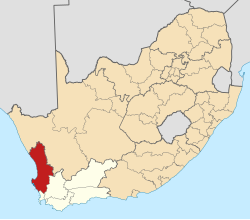
The municipality covers a total area of 2,015 square kilometres (778 sq mi) which includes the West Coast Peninsula (also known as the Vredenburg Peninsula) and stretches southeast to include the West Coast National Park and the area around Hopefield. It abuts on the Bergrivier Municipality to the north and the Swartland Municipality to the east and south.

According to the 2011 census the municipality has a population of 99,193 people in 28,835 households. Of this population, 55.8% describe themselves as "Coloured", 24.5% as "Black African", and 18.0% as "White". The first language of 72.5% of the population is Afrikaans, while 16.4% speak Xhosa, 6.6% speak English and 1.2% speak Sotho. [5]

The seat of the municipality and its largest town is Vredenburg, which is situated in the center of the eponymous peninsula and according to the 2011 census has a population of 38,382. To the south of Vredenburg is the harbour town of Saldanha (pop. 28,142) on the edge of Saldanha Bay. There are several other fishing and holiday towns on the coast of the municipality: St Helena Bay (pop. 11,529) on the northern coast of the Vredenburg Peninsula, Paternoster (pop. 1,971) and Jacobsbaai (pop. 416) on the western coast of the peninsula, and Langebaan (pop. 8,297) on the opposite side of Saldanha Bay from Saldanha. In the interior of the municipality is the town of Hopefield (pop. 6,460) and the village and air force base at Langebaanweg (pop. 952).

History

The towns of Vredenburg and Saldanha were united under a single Vredenburg-Saldanha Municipality in 1975. At the end of the apartheid era, in the area that is today the Saldanha Bay Municipality there were also municipal councils for Hopefield, Langebaan and St Helena Bay. These councils were elected by the white residents, while the coloured residents of the towns were governed by management committees subordinate to the white councils.

While the negotiations to end apartheid were taking place a process was established for local authorities to negotiate voluntary mergers. Hopefield took part in this process, merging the municipal council with the management committee in November 1992. Langebaan did the same in April 1993.

After the national elections of 1994 a process of local government transformation began, in which negotiations were held between the existing local authorities, political parties, and local community organisations. As a result of these negotiations, the existing local authorities were dissolved and transitional local councils (TLCs) were created in January 1995. The Hopefield and Langebaan municipalities were each replaced with a TLC. The West Coast Peninsula TLC replaced the Vredenburg-Saldanha Municipality, the St Helena Bay Municipality, and their respective management committees.

The transitional councils were initially made up of members nominated by the various parties to the negotiations, until May 1996 when elections were held. At these elections the West Coast District Council was established, replacing the West Coast Regional Services Council. Transitional representative councils (TRCs) were also elected to represent rural areas outside the TLCs on the District Council; the area that was to become Bergrivier Municipality included part of the Malmesbury TRC.

At the local elections of December 2000 the TLCs and TRCs were dissolved and the Saldanha Bay Municipality was established as a single local authority incorporating both rural and urban areas. In 2006 the boundary of the municipality was adjusted slightly to transfer a strip of land on the left bank of the Berg River (adjacent to Velddrif) to the Bergrivier Local Municipality. In 2011 the West Coast National Park, previously a District Management Areas, was added to the municipality when District Management Areas were abolished.

Politics

The municipal council consists of twenty-seven members elected by mixed-member proportional representation. Fourteen councillors are elected by first-past-the-post voting in fourteen wards, while the remaining thirteen are chosen from party lists so that the total number of party representatives is proportional to the number of votes received. In the election of 1 November 2021 the Democratic Alliance (DA) won a plurality of thirteen seats on the council.

The following table shows the results of the 2021 election. [6]

Saldanha Bay local election, 1 November 2021
PartyVotesSeats
WardListTotal %WardListTotal
Democratic Alliance 14,19014,52428,71446.3%10313
African National Congress 6,6136,80913,42221.7%426
Good 4,3294,2308,55913.8%044
Freedom Front Plus 1,5461,3342,8804.6%011
Patriotic Alliance 1,3651,3092,6744.3%011
Economic Freedom Fighters 9339881,9213.1%011
Cape Coloured Congress 4364418771.4%011
Independent candidates 4244240.7%00
6 other parties1,2591,2362,4954.0%000
Total31,09530,87161,966141327
Valid votes31,09530,87161,96698.8%
Spoilt votes 2574837401.2%
Total votes cast31,35231,35462,706
Voter turnout31,445
Registered voters61,441
Turnout percentage51.2%

Related Research Articles

<span class="mw-page-title-main">Knysna Local Municipality</span> Local municipality in Western Cape, South Africa

Knysna Municipality is a local municipality within the Garden Route District Municipality, in the Western Cape province of South Africa. As of 2011, the population is 68,659. Its municipal code is WC048.

<span class="mw-page-title-main">George Local Municipality</span> Local municipality in Western Cape, South Africa

George Municipality is a local municipality within the Garden Route District Municipality, in the Western Cape province of South Africa. As of 2011, the population is 193,672. Its municipality code is WC044.

<span class="mw-page-title-main">Mossel Bay Local Municipality</span> Local municipality in Western Cape, South Africa

Mossel Bay Municipality is a local municipality within the Garden Route District Municipality, in the Western Cape province of South Africa. As of 2011, the population was 89,430.

<span class="mw-page-title-main">Witzenberg Local Municipality</span> Local municipality in Western Cape, South Africa

Witzenberg Municipality is a local municipality located within the Cape Winelands District Municipality, in the Western Cape province of South Africa. As of 2011 it had a population of 115,946.

<span class="mw-page-title-main">West Coast District Municipality</span> District municipality in Western Cape, South Africa

The West Coast District Municipality is a district municipality located in the Western Cape province of South Africa. Its municipality code is DC1. Moorreesburg is the seat of the district. As of 2011, it had a total population of 391,766.

<span class="mw-page-title-main">Langeberg Local Municipality</span> Local municipality in Western Cape, South Africa

Langeberg Municipality, known before 28 August 2009 as Breede River/Winelands Municipality, is a local municipality located within the Cape Winelands District Municipality, in the Western Cape province of South Africa. As of 2011, it had a population of 97,724. Its municipality code is WC026.

<span class="mw-page-title-main">Beaufort West Local Municipality</span> Local municipality in Western Cape, South Africa

Beaufort West Municipality is a local municipality located in the Western Cape province of South Africa. As of 2011, the population is 49,586. Its municipality code is WC053.

<span class="mw-page-title-main">Overstrand Local Municipality</span> Local municipality in Western Cape, South Africa

Overstrand Municipality is a local municipality in the Western Cape province of South Africa. It is located along the Atlantic coast between Cape Town and Cape Agulhas, within the Overberg District Municipality. The principal towns in the municipality are Hermanus, Gansbaai and Kleinmond. As of 2011, it had a population of 80,432.

<span class="mw-page-title-main">Drakenstein Local Municipality</span> Local municipality in Western Cape, South Africa

Drakenstein Municipality is a local municipality located within the Cape Winelands District Municipality, in the Western Cape province of South Africa. As of 2011, it had a population of 251,262. Its municipality code is WC023.

<span class="mw-page-title-main">Bergrivier Local Municipality</span> Local municipality in Western Cape, South Africa

Bergrivier Municipality is a local municipality in the Western Cape province of South Africa. It governs the towns of Piketberg, Velddrif and Porterville, as well as the surrounding villages and rural areas. As of 2011, it had a population of 61,897. It is located within the West Coast District Municipality and its municipality code is WC013.

<span class="mw-page-title-main">Breede Valley Local Municipality</span> Local municipality in Western Cape, South Africa

Breede Valley Municipality is a local municipality located within the Cape Winelands District Municipality, in the Western Cape province of South Africa. As of 2007, it had a population of 166,825. Its municipality code is WC025.

<span class="mw-page-title-main">Cape Agulhas Local Municipality</span> Local municipality in Western Cape, South Africa

Cape Agulhas Municipality is a municipality located in the Western Cape province of South Africa. As of 2011, it had a population of 33,038. Its municipality code is WC033. It is named after Cape Agulhas, the southernmost point of Africa. The largest town is Bredasdorp, which is the seat of the municipal headquarters. It also includes the villages of Napier, Struisbaai, Elim, Arniston and L'Agulhas, and the De Hoop Nature Reserve.

<span class="mw-page-title-main">Cederberg Local Municipality</span> Local municipality in Western Cape, South Africa

Cederberg Municipality is a local municipality which governs an area of the Western Cape province of South Africa stretching from the Cederberg mountains through the middle valley of the Olifants River to the Atlantic coast. It includes the towns of Clanwilliam, Citrusdal and Lamberts Bay, and the surrounding villages and farms. As of 2011 it had a population of 49,768. It is located within the West Coast District Municipality and its municipality code is WC012.

<span class="mw-page-title-main">Laingsburg Local Municipality</span> Local municipality in Western Cape, South Africa

Laingsburg Municipality is a local municipality located in the Western Cape province of South Africa. As of 2011, the population is 8,289. Its municipality code is WC051.

<span class="mw-page-title-main">Hessequa Local Municipality</span> Local municipality in Western Cape, South Africa

Hessequa Municipality, known before 24 June 2005 as Langeberg Municipality, is a local municipality within the Garden Route District Municipality, in the Western Cape province of South Africa. It is flanked by the lower Breede River to the west and the Gourits River to the east. As of 2011, the population was 52,642. Its municipality code is WC042. The name Hessequa, meaning "people of the trees", refers to the indigenous Khoikhoi people.

<span class="mw-page-title-main">Matzikama Local Municipality</span> Local municipality in Western Cape, South Africa

Matzikama Municipality is a local municipality which governs the northernmost part of the Western Cape province of South Africa, including the towns of Vredendal, Vanrhynsdorp, Klawer and Lutzville, and the surrounding villages and rural areas. As of 2011, it had a population of 67,147. It forms part of the West Coast District Municipality, and its municipality code is WC011.

<span class="mw-page-title-main">Swartland Local Municipality</span> Local municipality in Western Cape, South Africa

Swartland Municipality is a local municipality located in the Western Cape province of South Africa. Malmesbury is the seat of the municipality. As of 2022, it had a population of 148,331. Its municipality code is WC015.

<span class="mw-page-title-main">Swellendam Local Municipality</span> Local municipality in Western Cape, South Africa

Swellendam Municipality is a local municipality located within the Overberg District Municipality, in the Western Cape province of South Africa. As of 2011, it had a population of 35,916. Its municipality code is WC034.

<span class="mw-page-title-main">Theewaterskloof Local Municipality</span> Local municipality in Western Cape, South Africa

Theewaterskloof Municipality is a local municipality located within the Overberg District Municipality, in the Western Cape province of South Africa. As of 2007, the population was 108,790. Its municipality code is WC031. The enormous Theewaterskloof Dam, which provides water for Cape Town and the surrounding areas, is located in this municipality.

<span class="mw-page-title-main">Hopefield, South Africa</span> Place in Western Cape, South Africa

Hopefield is a settlement in West Coast District Municipality in the Western Cape province of South Africa on the R45 between Malmesbury and Vredenburg. The town lies east of Saldanha Bay and Langebaan, 40 km (25 mi) southeast of Vredenburg and 120 km (75 mi) north of Cape Town.

References

  1. "Contact list: Executive Mayors". Government Communication & Information System. Archived from the original on 14 July 2010. Retrieved 22 February 2012.
  2. "Saldanha Bay Municipality". Saldanha Bay Municipality – The Saldanha Bay Municipality. Postal Address. Retrieved 2024-08-08.
  3. 1 2 3 "Statistics by place". Statistics South Africa. Retrieved 7 August 2024.
  4. "Statistics by place". Statistics South Africa. Retrieved 27 September 2015.
  5. "Saldanha Bay Local Municipality". Census 2011.
  6. "Election Result Table for LGE2021 — Saldanha Bay". wikitable.frith.dev. Retrieved 2021-11-08.