Saldanha, South Africa

Last updated

Saldanha
Saldanha strand.jpg
Fishermen's Cottages, Saldanha. 1918. Oval shaped cottages, built by George Goode Busch. 02.JPG
Saldanha Bay.jpg
Mariena ontwikkeling.jpg
Saldana - panoramio.jpg
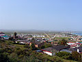
Clockwise from Top: Saldanha beach, Saldanha at night, indigenous vegetation, view over the town, traditional fishermans cottages
South Africa Western Cape location map.svg
Red pog.svg
Saldanha
South Africa adm location map.svg
Red pog.svg
Saldanha
Coordinates: 32°59′52″S17°56′44″E / 32.99778°S 17.94556°E
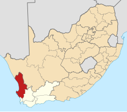
 / -32.99778; 17.94556
Country South Africa
Province Western Cape
District West Coast
Municipality Saldanha Bay
Area
[1]
  Total
17.36 km2 (6.70 sq mi)
Population
 (2011) [1]
  Total
28,142
  Density1,600/km2 (4,200/sq mi)
Racial makeup (2011)
[1]
   Black African 29.9%
   Coloured 65%
   Indian/Asian 1.4%
   White 13.5%
  Other0.9%
First languages (2011)
[1]
   Afrikaans 70.3%
   Xhosa 19.6%
   English 7.0%
  Other3.1%
Time zone UTC+2 (SAST)
Postal code (street)
7395
PO box
7395
Area code 022

Saldanha (Afrikaans: [sal'dana] ), also known as Saldanha Bay, is a town of 21,636 people, located 110 kilometres (70 mi) north of Cape Town on the northern shore of Saldanha Bay, in the Western Cape province of South Africa. Its situation as a natural sheltered harbour has led to development as a port for the export of iron ore from Sishen in the Northern Cape, which is transported on the Sishen–Saldanha railway line. The port is one of the largest exporting ports of ore in the whole of Africa, and it is able to handle ships as large as 200 000 tons deadweight. [2]

Contents

History

St. Helena, this island belongs to ye English east India Company whose ships usually touch here for a recruit of fresh water and provisions - ; The bay of Agao de Saldanha, this bay is 70 miles north (5961367644).jpg
Historic map of Saldanha by the East India Company (bottom).

'Agoada de Saldanha' was the early Portuguese name for Table Bay, but later given to the present location by Joris van Spilbergen, meaning 'watering place of Saldanha'. [3]

Bartolomeu Dias was the first recorded European to set eyes on what is now Saldanha. [4]

Saldanha Bay is ultimately named after António de Saldanha, captain of a vessel in Albuquerque's fleet which visited South Africa in 1503.

Port

The port has handling facilities for both bulk iron ore and crude oil. [5] Ore vessels up to 21.5 metre draft are handled, as well as large crude oil carriers up to 20.5 metre draft. [5]

Demographics (2011)

Source: [6]

GenderPopulationPercentage
Male 14,26450.69
Female 13,87849.31
Total28,142100
RacePopulationPercentage
Black 8,40429.9
White 3,81113.5
Coloured 15,28654.3
Asian 3911.4
Other2500.9
Total28,142100
First languagePopulationPercentage
Afrikaans 18,52470.3
Xhosa 5,17619.6
English 1,0597.0
Southern Sotho 1,8350.78
Tswana 1700.65
Other 1,3601.67
Total28,142100

References

  1. 1 2 3 4 "Main Place Saldanha". Census 2011.
  2. "Saldanha" (PDF). Saldanha Bay Local Municipality. Retrieved 22 March 2010.
  3. Raper, P.E. (1989). Dictionary of Southern African Place Names.
  4. "Agoada de Saldanha". South Africa History Online. Retrieved 2024-06-08.
  5. 1 2 "Port of Saldanha Bay, South Africa". findaport.com.[ permanent dead link ]
  6. , Census 2011 — Main Place "Saldanha"