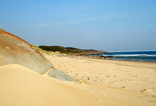
The Croajingolong National Park is a coastal national park located in the East Gippsland region of the Australian state of Victoria. The 88,355-hectare (218,330-acre) national park is situated approximately 450 kilometres (280 mi) east of Melbourne and 500 kilometres (310 mi) south of Sydney.
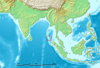
The Nicobar Islands are an archipelagic island chain in the eastern Indian Ocean. They are located in Southeast Asia, 150 kilometres (93 mi) northwest of Aceh on Sumatra, and separated from Thailand to the east by the Andaman Sea. Located 1,300 kilometres (810 mi) southeast of the Indian subcontinent, across the Bay of Bengal, they are part of India, as the Nicobar district within the union territory of the Andaman and Nicobar Islands.

Overberg is a region in South Africa to the east of Cape Town beyond the Hottentots-Holland mountains. It lies along the Western Cape Province's south coast between the Cape Peninsula and the region known as the Garden Route in the east. The boundaries of the Overberg are the Hottentots-Holland mountains in the West; the Riviersonderend Mountains, part of the Cape Fold Belt, in the North; the Atlantic and Indian Oceans in the South and the Breede River in the East.
New Jersey Pinelands National Reserve is a national reserve that encompasses the New Jersey Pine Barrens.

The Golden Gate Biosphere Network is an internationally recognized voluntary coalition of federal, state, and local government agencies, nonprofit organizations, universities, and private partners within the Golden Gate Biosphere (GGB) region. The Network works towards protecting the biosphere region’s biodiversity and conserving its natural resources to maintain the quality of life for people within the region. The Network has been part of the UNESCO Man and Biosphere Programme since 1988 and is part of the US Biosphere Network and EuroMAB. It is recognized by UNESCO due to the significant biodiversity of the region, as well as the Network's efforts to demonstrate and promote a balanced relationship between humans and the biosphere.

The Coast Ranges of California span 400 miles (644 km) from Del Norte or Humboldt County, California, south to Santa Barbara County. The other three coastal California mountain ranges are the Transverse Ranges, Peninsular Ranges and the Klamath Mountains.

The Kwazulu-Cape coastal forest mosaic is a subtropical moist broadleaf forest ecoregion of South Africa. It covers an area of 17,800 square kilometers (6,900 sq mi) in South Africa's Eastern Cape and KwaZulu-Natal provinces.

Helderberg refers to a planning district of the City of Cape Town metropolitan municipality, the mountain after which it is named, a wine-producing area in the Western Cape province of South Africa, or a small census area in Somerset West.

The Waterberg is a mountainous massif of approximately 654,033 hectare in north Limpopo Province, South Africa. The average height of the mountain range is 600 m with a few peaks rising up to 2000 m above sea level. Vaalwater town is located just north of the mountain range. The extensive rock formation was shaped by hundreds of millions of years of riverine erosion to yield diverse bluff and butte landform. The ecosystem can be characterised as a dry deciduous forest or Bushveld. Within the Waterberg there are archaeological finds dating to the Stone Age, and nearby are early evolutionary finds related to the origin of humans.

The West Coast National Park lies 88 km (55 mi) north of Cape Town in the Western Cape province of South Africa. The park is found inside of the Cape West Coast Biosphere Reserve, part of the UNESCO Man and the Biosphere Programme. It is bordered by the Atlantic Ocean on the west and the R27 coastal road, and runs from the town of Yzerfontein in the south, up to the Langebaan Lagoon. The park is particularly well known for its bird life and for the spring flowers which occur in the months from August to September, especially in the Postberg flower reserve section of the park. The park, with the islands in Saldanha Bay, has been identified by BirdLife International as an Important Bird Area. The park was proclaimed in 1985, and is 36,259.8 hectares (140.000 sq mi) in size.
The Kruger to Canyons Biosphere Region is a biosphere reserve situated in the north eastern region of South Africa, straddling Limpopo and Mpumalanga Provinces. In 2001, under the supervision of the then Department of Environmental Affairs (DEA), the Kruger to Canyons Biosphere Region was officially ratified by UNESCO as part of the Man and the Biosphere (MaB) Programme. UNESCO's Man and the Biosphere Programme provides a framework for exploring local solutions to challenges by mainstreaming biodiversity conservation and sustainable development, integrating economic, social and environmental aspects and recognizing their vital linkages within specific learning landscapes adjacent to Protected Areas.

Cu Lao Cham Marine Park also known as Cham Islands Biosphere Reserve is part of the eight islets of the Chàm Islands, located in the South China Sea under the administration of Tân Hiệp Commune and Hội An town, in Quảng Nam Province, Vietnam. The terrestrial and coastal ecosystems of the islands have been recognized as a global Biosphere Reserve by UNESCO on 26 May 2009 under its 'Man and the Biosphere Programme' for its rich biodiversity value. The eco system also includes the ancient Hội An, which is 20 kilometres (12 mi) away from the islands, a UNESCO World Heritage Site.

Kogelberg Nature Reserve is a nature reserve of 3,000 ha comprising the Kogelberg Mountain Range, to the east of Cape Town, South Africa.

Many areas of Vietnam are under protection. While the national reserves cover small areas of scientific significance with restricted access, the national parks also cover wetlands of Ramsar designated areas and BirdLife International inscribed bird areas. The largest of the national parks initially covered were the Cúc Phương National Park, the Cát Tiên National Park, and the Côn Đảo National Park which to start with were forest areas cum reserves or prohibited areas. The objective for creating national parks was to allow access to the reserved areas as a part of ecotourism and cultural needs with full attention to the basic approach of conservation of natural environmental resources.
The wildlife of Lebanon refers to the flora and fauna of Lebanon, a country in Asia located at the eastern end of the Mediterranean Sea. The country has four main geographical areas: the coastal plain, Mount Lebanon, the Beqaa Valley and the Anti-Lebanon Mountains. The climate is Mediterranean, with the coastal regions experiencing hot, humid summers and cool, wet winters, and the elevated areas inland experiencing colder winters with snow that lingers on into the summer. The country offers a variety of habitats for wildlife, including mountains, valleys, marshes, coastal plains, salt marshes and sea coasts.

Dalnevostochny Morskoy Nature Reserve is Russia's first marine reserve, covering large portions of the sea and 30 islands in Peter the Great Gulf, on the west side of the Sea of Japan. It has the highest class of environmental protection as a federal 'zapovednik'. There are four distinct areas with different biological and protection regimes, covering 63,000 ha (240 sq mi) of sea area, additional land on included islands, a 500-meter conservation strip of coastline along the marine area, and a conservation buffer zone inland to a width of 3 miles. The reserve is situated on the continental coast south of Vladivostok in the Russian Far East. The administrative district is Khasansky District of Primorsky Krai. It was formally established in 1978. The reserve is part of the UNESCO "Far East Reserve" MAB Biosphere Reserve, noted for its protection of marine biodiversity, and as a re-population area for open seas fisheries.
The Gouritz Cluster Biosphere Reserve is located in the Western Cape of South Africa. It is the 7th and largest of South Africa’s biosphere reserves; divided into four connected sectors ranging from sea level to 2,240 metres. The area is the only place in the world where three recognised biodiversity hotspots converge. The site is characterised by high endemism of plant species and threatened invertebrates including seven endemic species of the enigmatic beetle genus Colophon and 14 butterfly species. It provides a migratory route for large mammals such as the leopard and serves as a nursery for marine species.
The Cape Winelands Biosphere Reserve is located in the Western Cape Province of South Africa approximately 40 km east of Cape Town. The Biosphere Reserve extends from the Kogelberg Biosphere Reserve in the south, northwards along the Cape Fold Belt Mountain Chain and the adjoining valleys constituting the Cape Winelands. The Biosphere Reserve incorporates key portions of the registered Cape Floral Region Protected Areas World Heritage Site. The Reserve was designated in 2007.

Bras d'Or Lake Biosphere Reserve is a UNESCO Biosphere Reserve located at Bras d'Or Lake, Cape Breton Island, Nova Scotia, Canada. It consists of a salt-water estuary watershed inland sea with three passages to the Atlantic Ocean. The Holocene transgression flooded a complex river-lake system of diverse geology, creating the small, deep inland sea with 12 significant watersheds draining both highlands and lowlands.


