Area is the measure of a region's size on a surface. The area of a plane region or plane area refers to the area of a shape or planar lamina, while surface area refers to the area of an open surface or the boundary of a three-dimensional object. Area can be understood as the amount of material with a given thickness that would be necessary to fashion a model of the shape, or the amount of paint necessary to cover the surface with a single coat. It is the two-dimensional analogue of the length of a curve or the volume of a solid . Two different regions may have the same area ; by synecdoche, "area" sometimes is used to refer to the region, as in a "polygonal area".

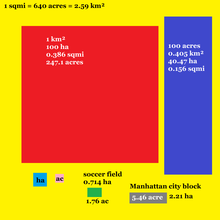
The square metre or square meter is the unit of area in the International System of Units (SI) with symbol m2. It is the area of a square with sides one metre in length.

Munds Park is an unincorporated census-designated place (CDP) in Coconino County, Arizona, United States. The year round population was 631 at the 2010 census.

Hot Springs Village is a census-designated place (CDP) in Garland and Saline counties in the U.S. state of Arkansas. As it is situated in two counties, it is also part of two metropolitan statistical areas. The portion in Garland County is within the Hot Springs Metropolitan Statistical Area, while the portion extending into Saline County is part of the Little Rock–North Little Rock–Conway Metropolitan Statistical Area. The population was 15,861 at the 2020 census. It is the largest gated community in the United States.

Pike Creek is a census-designated place (CDP) in New Castle County, Delaware, United States and is part of the Philadelphia-Camden-Wilmington, PA-NJ-DE-MD Metropolitan statistical area. In 2007, CNN's Money Magazine ranked Pike Creek number 1 on its list of the 100 Best Places to Live in the United States. Pike Creek was the only community in Delaware to appear on the list. The population was 7,808 at the 2020 Census. Local attractions include Middle Run Natural Area, White Clay Creek State Park, Carousel Farm Park and Equestrian Center, Golf and Restaurants. Pike Creek is approximately five miles from downtown Newark, which contains the University of Delaware. Pike Creek is connected to the University of Delaware campus and the Newark downtown area by several bike trails. Pike Creek is approximately 10 miles west of the state's largest city, Wilmington, which is a national financial center.

Bartlett is a village in Illinois, United States. The population was 41,105 at the 2020 census. The village is primarily located in Cook and DuPage counties, with a small parcel on the western border located in Kane County. Bartlett is part of the Chicago metropolitan area.

Stansbury Park is a census-designated place (CDP) in Tooele County, Utah, United States. As of the 2020 United States Census, the population was 9,851, up from the 2010 figure of 5,145.

St. Peters is a city in St. Charles County, Missouri, United States. The population was 57,732 at the 2020 census, making it the eleventh-largest city in Missouri. It is a northwestern suburb of St. Louis.

Sharm El Sheikh, alternatively rendered Sharm el-Sheikh, Sharm el Sheikh, or Sharm El-Sheikh, is an Egyptian city on the southern tip of the Sinai Peninsula, in South Sinai Governorate, on the coastal strip along the Red Sea. Its population is approximately 13,000 as of 2023. Sharm El Sheikh is the administrative hub of Egypt's South Sinai Governorate, which includes the smaller coastal towns of Dahab and Nuweiba as well as the mountainous interior, St. Catherine and Mount Sinai. It was historically a fishing town and military base, and was developed into a commercial and tourist-centric city in 1968 by Israel. Today, the city and holiday resort is a significant centre for tourism in Egypt, while also attracting many international conferences and diplomatic meetings.
Blackhawk is an unincorporated planned community and census-designated place located in Contra Costa County, California, United States, east of Danville and Oakland. As of the 2010 census it had a population of 9,354. Governed by county rules/regulations and a homeowner association (HOA), Blackhawk has a country club, two golf courses, sports complex, restaurants, and the adjacent Blackhawk Plaza. 24-hour security plus additional law enforcement contracted through the Contra Costa County Sheriff's Office is provided by HOA dues. The area is covered by the San Ramon Valley Fire Protection District. The ZIP code is 94506. The community is inside area code 925. Blackhawk is known for its uniform architecture and suburban lifestyle, with the median household income being $167,875 and median home price of $1,117,500.

Guildford is a suburb of Sydney, in the state of New South Wales, Australia. Guildford is located 27 kilometres west of the Sydney central business district, in the local government area of Cumberland City Council. Guildford is part of the Western Sydney region.
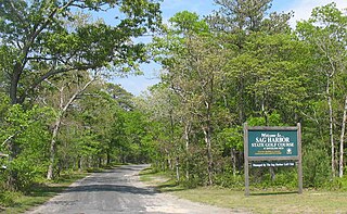
The Sag Harbor State Golf Course is 48.8-acre (197,000 m2), 9-hole golf facility is located in the middle of a 341-acre (1.38 km2) parcel known as the Barcelona Neck Natural Resources Management Area. The golf course is entirely located in the town of East Hampton in Suffolk County, New York, United States.
Mile Square Regional Park is an urban park in Fountain Valley, California, United States. It includes two lakes, three 18-hole golf courses, an archery range, baseball and softball fields, picnic shelters, a 20-acre (81,000 m2) urban nature area planted with California native plants, a 55-acre (220,000 m2) recreation center with tennis courts, basketball courts, racquetball courts, a gymnasium, the Kingston Boys & Girls Club, and a community center. This regional park was built on a naval landing field soon after the city was incorporated. James Kanno, one of America's first Japanese American mayors, led the effort to create the park.

The Grant Devine Dam, formerly Alameda Dam, is an embankment dam located in the Canadian province of Saskatchewan near Alameda and Oxbow. It was constructed in 1994 to control flows on Moose Mountain Creek and Souris River. It provides flood protection and irrigation for this area of Saskatchewan, along with protection for Minot, North Dakota. The Grant Devine Reservoir provides opportunities for recreational use such as boating and fishing. At the full supply level of 562 metres (1,844 ft), the reservoir holds 105,000,000 m3 (3.7×10⁹ cu ft) of water. The project is owned and operated by the Saskatchewan Water Security Agency (formerly Saskatchewan Watershed Authority).

The Rural Municipality of Canwood No. 494 is a rural municipality (RM) in the Canadian province of Saskatchewan within Census Division No. 16 and SARM Division No. 5. The RM is located in the north-central portion of the province, west of the city of Prince Albert.
Horseshoe Valley Resort, formerly Horseshoe Valley Ski Club, is an Ontario ski resort and four season vacation destination. Located north of Barrie, the resort is 110 km north of Toronto. The resort enjoys a long ski season due to snowmaking abilities. Acquired by Freed Hotels and Resorts in 2021, Horseshoe Resort is spread out over 680 acres (280 ha) of land. The resort offers 29 ski runs, over 30 kilometres of Nordic trails, 18-hole Valley golf course, Amba Spa, 101 rooms at the on-site inn, 40 condo-style suites, two year-round restaurants, 16,000 square feet (1,500 m2) of meeting and banquet facilities, indoor and outdoor swimming pools, a full gym, and over 25 miles (40 km) of trails connected to the Copeland Forest suitable for hiking, biking and snowshoeing.
Shell Lake is a village in the Canadian province of Saskatchewan within the Rural Municipality of Spiritwood No. 496 and Census Division No. 16. This village is 90 kilometres west of the City of Prince Albert. It was formerly part of the Rural Municipality (RM) of Shell Lake No. 495 before it was absorbed by the RM of Spiritwood No. 496. It is the administrative centre of the Ahtahkakoop Cree First Nation band government.

Elbow is a village in the Canadian province of Saskatchewan within the Rural Municipality of Loreburn No. 254 and Census Division No. 11. Elbow was founded in 1909, near what is now Lake Diefenbaker. It is 8 kilometres (5.0 mi) north-west of Mistusinne, 10 kilometres (6.2 mi) north-west of Douglas Provincial Park, and 16 kilometres (9.9 mi) south-east of Loreburn. The village got its name from its position on the elbow of the South Saskatchewan River.
Pasatiempo is an unincorporated community and census-designated place (CDP) in Santa Cruz County, California, United States, located along State Route 17 between Scotts Valley and Santa Cruz. Bus service is provided by Santa Cruz Metro and the Highway 17 Express. Pasatiempo sits at an elevation of 394 feet (120 m). The 2020 United States census reported Pasatiempo's population was 1,093.
Quail Valley is a neighborhood dating from 1969 of Missouri City, in Fort Bend County, Texas, United States.