
A metropolitan area, sometimes referred to as a metro area or commuter belt, is a region consisting of a densely populated urban core and its less-populated surrounding territories, sharing industry, infrastructure, and housing. A metro area usually comprises multiple jurisdictions and municipalities: neighborhoods, townships, boroughs, cities, towns, exurbs, suburbs, counties, districts, states, and even nations like the eurodistricts. As social, economic and political institutions have changed, metropolitan areas have become key economic and political regions. Metropolitan areas include one or more urban areas, as well as satellite cities, towns and intervening rural areas that are socioeconomically tied to the urban core, typically measured by commuting patterns. In the United States, the concept of the metropolitan statistical area has gained prominence.
A district is a type of administrative division that, in some countries, is managed by local government. Across the world, areas known as "districts" vary greatly in size, spanning regions or counties, several municipalities, subdivisions of municipalities, school district, or political district.
A media market, broadcast market, media region, designated market area (DMA), television market area, or simply market is a region where the population can receive the same television and radio station offerings, and may also include other types of media including newspapers and Internet content. They can coincide or overlap with one or more metropolitan areas, though rural regions with few significant population centers can also be designated as markets. Conversely, very large metropolitan areas can sometimes be subdivided into multiple segments. Market regions may overlap, meaning that people residing on the edge of one media market may be able to receive content from other nearby markets. They are widely used in audience measurements, which are compiled in the United States by Nielsen Media Research. Nielsen measures both television and radio audiences since its acquisition of Arbitron, which was completed in September 2013.

Theewaterskloof Municipality is a local municipality located within the Overberg District Municipality, in the Western Cape province of South Africa. As of 2007, the population was 108,790. Its municipality code is WC031. The enormous Theewaterskloof Dam, which provides water for Cape Town and the surrounding areas, is located in this municipality.
Local government in South Africa consists of municipalities of various types. The largest metropolitan areas are governed by metropolitan municipalities, while the rest of the country is divided into district municipalities, each of which consists of several local municipalities. After the municipal election of 18 May 2011 there were eight metropolitan municipalities, 44 district municipalities and 226 local municipalities. Since the boundary reform at the time of the municipal election of 3 August 2016 there are eight metropolitan municipalities, 44 district municipalities and 205 local municipalities.

Sarah Baartman District Municipality is situated in the western part of the Eastern Cape province, covering an area of 58 242 square kilometres. The area of the district municipality includes nine local municipalities. The seat of Sarah Baartman is the city of Port Elizabeth, although Port Elizabeth is not itself in the district. The largest languages among the 388,201 people are Xhosa and Afrikaans.. The district code is DC10.

The City of Cape Town is the metropolitan municipality which governs the city of Cape Town, South Africa and its suburbs and exurbs. As of the 2011 census, it had a population of 3,740,026.

Güzelbahçe is a coastal district of İzmir Province in Turkey. Until 2009 Local Government Elections, Greater İzmir Municipality had 9 district (second-tier) municipalities and Güzelbahçe was one of the smallest district municipality in terms of land area and population. With March 2009 Local Elections, İzmir Greater (Metropolitan) Municipality now have 21 district municipalities, since new municipalities had established due to high population of some major second-tier municipalities like Karşıyaka and Konak. Now, İzmir Greater (Metropolitan) Municipality has several smaller municipalities in terms of land area coverage, however, Güzelbahçe still remains as the smallest municipality within the metropolitan area in terms of population. March 2009 Local Elections of Turkey has also resulted of mergers of villages and town municipalities with their respective second-tier / district municipalities in all greater municipalities. Therefore, parallel to this regulation and changes, Yelki town municipality and Çamlık Villages become part of Güzelbahçe Municipality in 2009. Although the population of Güzelbahçe Municipality increased little, the land area increased greatly. The population and land borders of Güzelbahçe County/District however remained same. Güzelbahçe is part of the İzmir Greater (Metropolitan) Area and Municipality since the establishment of İzmir Greater Municipality in 1984. Although Güzelbahçe seems very urbanized at the rate of 82,7 percent, there are relatively remote villages in the Southern part of the Güzelbahçe Municipality. These villages, like Payamlı, Kavacık, are/were part of the Güzelbahçe County/District and famous with their delicious grapes grown on mostly steep hills and mountains. Vineyards during summer and autumns have worth to visits and grapes are definitely worth to taste due to natural growth. Grapes in the vineyards different due to lack of major irrigation or watering.
Municipal elections were held in South Africa on 1 March 2006, to elect members to the local governing councils in the municipalities of South Africa. The municipalities form the local government of South Africa and are subdivisions of the provinces, thus making them responsible for local service delivery, such as electricity, water and fire services.
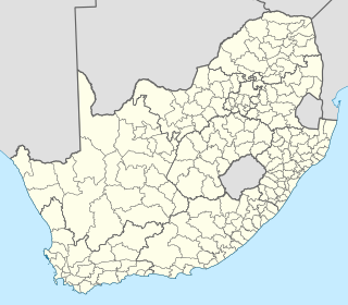
The nine provinces of South Africa are divided into 52 districts, which are either metropolitan or district municipalities. They are the second level of administrative division, below the provinces and above the local municipalities.
A district municipality is a designation for a class of municipalities found in several locations, including Canada, Lithuania, and South Africa.

Motheo was, until the municipal elections of 18 May 2011, a district of the Free State province of South Africa. At the time of the 2011 elections it was disestablished as a consequence of Mangaung Local Municipality being upgraded to a metropolitan municipality
A local government area (LGA) is an administrative division of a country that a local government is responsible for. The size of an LGA varies by country but it is generally a subdivision of a state, province, division, or territory.

The Polokwane Local Municipality is a local municipality located within the Capricorn District in the Limpopo Province of South Africa. It shares its name with the city of Polokwane.

A metropolis is a large city or conurbation which is a significant economic, political, and cultural center for a country or region, and an important hub for regional or international connections, commerce, and communications. The term is Ancient Greek (μητρόπολις) and means the "mother city" of a colony, that is, the city which sent out settlers. This was later generalized to a city regarded as a center of a specified activity, or any large, important city in a nation.

The Emfuleni Local Municipality is one of three local municipalities comprising the Sedibeng District in Gauteng, South Africa. It is the westernmost local municipality in the District, and covers an area of 987 km².
The primary administrative divisions of South Africa are the nine provinces. The provinces are divided into metropolitan and district municipalities, with the district municipalities being further divided into local municipalities. Metropolitan and local municipalities are divided into wards.


