This article needs additional citations for verification .(December 2009) |
Merweville | |
---|---|
Coordinates: 32°40′S21°31′E / 32.667°S 21.517°E | |
Country | South Africa |
Province | Western Cape |
District | Central Karoo |
Municipality | Beaufort West |
Government | |
• Councillor | Japie Van der Linde [1] (DA) |
Area | |
• Total | 32.59 km2 (12.58 sq mi) |
Population (2011) [2] | |
• Total | 1,592 |
• Density | 49/km2 (130/sq mi) |
Racial makeup (2011) | |
• Black African | 9.3% |
• Coloured | 78.1% |
• Indian/Asian | 2.6% |
• White | 8.9% |
• Other | 1.1% |
First languages (2011) | |
• Afrikaans | 95.0% |
• Zulu | 1.4% |
• Other | 3.6% |
Time zone | UTC+2 (SAST) |
PO box | 6940 |
Area code | 023 |
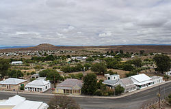
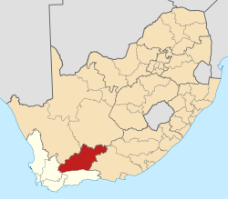
Merweville is a town located in Beaufort West Municipality, Western Cape.
Village 45 km north-west of Prince Albert Road and 130 km south-east of Beaufort West. It was established on the farm Vanderbylskraal in 1904 and administered by a village management board from 1921. Named after the Reverend P van der Merwe (1860-1940), minister at Beaufort West of the Dutch Reformed Church, and chairman of the church council which established the town. [3]
The town is an isolated community that maintains an old-world charm, about 150 km from Beaufort West. The surrounding region has been likened to that of Nevada or Arizona. It was one of the few towns or villages in the province not to be serviced by a sealed highway until the 40 km stretch of gravel road from the N1 was tarred in 2015.
One of the few remaining towns that still retains the old type laid back livestyle of days gone by - see Merweville for more information.
Every year the Dankfees festival is held which attracts thousands of people for the weekend. [4]
Die Boekklub, a hit drama series on kykNET and Showmax, about a book club, is filmed and set in the town. [5] [6] [7]
Thornaby-on-Tees, commonly referred to as Thornaby, is a town and civil parish in the North Yorkshire part of the borough of Stockton-on-Tees, England. The parish had a population of 24,741 at the 2011 census, in the Teesside built-up area. It is located on the south bank of the River Tees.
The N1 is a national route in South Africa that runs from Cape Town through Bloemfontein, Johannesburg, Pretoria and Polokwane to Beit Bridge on the border with Zimbabwe. It forms the first section of the famed Cape to Cairo Road.
The Karoo is a semi-desert natural region of South Africa. No exact definition of what constitutes the Karoo is available, so its extent is also not precisely defined. The Karoo is partly defined by its topography, geology and climate, and above all, its low rainfall, arid air, cloudless skies, and extremes of heat and cold. The Karoo also hosted a well-preserved ecosystem hundreds of million years ago which is now represented by many fossils.
Hanover is a small town in the Northern Cape Province of South Africa. Named after Hanover in Germany, the town was established in 1854.
Beaufort West Municipality is a local municipality located in the Western Cape province of South Africa. As of 2011, the population is 49,586. Its municipality code is WC053.
Laingsburg Municipality is a local municipality located in the Western Cape province of South Africa. As of 2022, the population is 11,366. Its municipality code is WC051.
Nelspoort is a town located in Beaufort West Local Municipality in the Western Cape, South Africa.
Aberdeen is a small town in the Sarah Baartman District Municipality of the Eastern Cape province of South Africa. With its numerous examples of Victorian architecture, it is one of the architectural conservation areas of the Karoo.
The Karoo National Park is a wildlife reserve in the Great Karoo area of the Western Cape, South Africa near Beaufort West. This semi-desert area covers an area of 750 square kilometres (290 sq mi). The Nuweveld portion of the Great Escarpment runs through the Park. It is therefore partly in the Lower Karoo, at about 850 m above sea level, and partly in the Upper Karoo at over 1300 m altitude.
The Karoo Supergroup is the most widespread stratigraphic unit in Africa south of the Kalahari Desert. The supergroup consists of a sequence of units, mostly of nonmarine origin, deposited between the Late Carboniferous and Early Jurassic, a period of about 120 million years.
Beaufort West is a town in the Western Cape province in South Africa. It is the largest town in the arid Great Karoo region, and is known as the "Capital of the Karoo". It forms part of the Beaufort West Local Municipality, with 34,085 inhabitants in 2011.
The N12 is a national route in South Africa which runs from George through Beaufort West, Kimberley, Klerksdorp and Johannesburg to eMalahleni.
The Cape Fold Belt is a fold and thrust belt of late Paleozoic age, which affected the sequence of sedimentary rock layers of the Cape Supergroup in the southwestern corner of South Africa. It was originally continuous with the Ventana Mountains near Bahía Blanca in Argentina, the Pensacola Mountains, the Ellsworth Mountains and the Hunter-Bowen orogeny in eastern Australia. The rocks involved are generally sandstones and shales, with the shales persisting in the valley floors while the erosion resistant sandstones form the parallel ranges, the Cape Fold Mountains, which reach a maximum height of 2325 m at Seweweekspoortpiek.
De Rust is a small village at the gateway to the Klein Karoo, South Africa. The name is Dutch and literally translates to "The Rest", referring to the town's original purpose of being a resting place for settlers en route through the challenging terrain of a nearby Swartberg gorge.
Victoria West is a town in the central Karoo region of South Africa's Northern Cape province. It is situated on the main N12 route, at an elevation of 1,300 metres (4,300 ft). It is the seat of the Ubuntu Local Municipality within the Pixley ka Seme District Municipality.
Karoo Hoogland Municipality is a local municipality within the Namakwa District Municipality, in the Northern Cape province of South Africa. The municipality incorporates the towns of Williston, Fraserburg and Sutherland. Although the towns are separated by more than 100 km by road, they share many administrative tasks.
Meiringspoort is a South African mountain pass on the N12 national road, where it crosses the Swartberg mountain range.
Murraysburg is an Afrikaans speaking town of approximately 5,000 people in the Western Cape province of South Africa. It is situated in the far northeast of the municipality, about 540 kilometres (340 mi) from the provincial capital Cape Town, and 80 kilometres (50 mi) west of Graaff-Reinet. It is governed as part of the Beaufort West Local Municipality within the Central Karoo District Municipality.
People of the Karoo refers to notable individuals who come from, or whose lives have included substantial engagement with, the area known as the Karoo. The Karoo is a widespread physiographic province in the western interior of South Africa, straddling much of the Northern Cape, southern Free State, Eastern Cape interior and parts of the Western Cape Provinces.
Prince Albert Road is a village located in Laingsburg Local Municipality, Western Cape.
Media related to Merweville at Wikimedia Commons
www.merweville.co.za