Twee Riviere

Last updated

Twee Riviere
South Africa Eastern Cape location map.svg
Red pog.svg
Twee Riviere
South Africa adm location map.svg
Red pog.svg
Twee Riviere
Coordinates: 33°50′26″S23°53′38″E / 33.84045°S 23.8939°E / -33.84045; 23.8939
Country South Africa
Province Eastern Cape
District Sarah Baartman
Municipality Kou-Kamma
Area
[1]
  Total2.72 km2 (1.05 sq mi)
Population
 (2011) [1]
  Total485
  Density180/km2 (460/sq mi)
First languages (2011)
[1]
   Afrikaans 77.9%
   English 8.5%
   Xhosa 6.8%
   Tswana 2.1%
  Other4.8%
Time zone UTC+2 (SAST)
PO box
6411

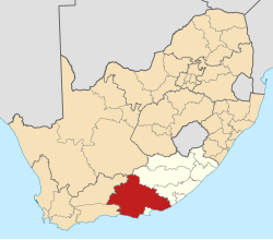
Twee Riviere (accepted spelling) is a town in Sarah Baartman District Municipality in the Eastern Cape province of South Africa.

The town is located in the Langkloof (Afrikaans for "long valley"). Twee Riviere (Afrikaans for "two rivers") takes its name from the Diep River (historically known as Klipdrif) and the Dwars River which arise in the Tsitsikamma Mountains to the south, flowing through the town. [2] Like so many other rivers in the Langkloof, these modest streams head inland for a considerable distance, before joining larger watercourses and gradually turning coastward.

The village of Twee Riviere is one of the earliest communities in the Langkloof, the original farm having been surveyed and registered under that name already on 14 February 1765. Originally a loan farm issued by the V.O.C. to Jacobus Scheepers, Twee Riviere was subsequently and briefly owned by Jacobus du Preez during the early 1780s, followed by Kritzinger and thereafter sold to Ockert Olivier in 1793. The Olivier family endures to this day, though during the 1800s and beyond holdings were increasingly also surrendered to families such as the Schreibers, Murrays, Ferreiras and others. Numerous descendants of these founding families formally acquired landholding by way of subdivision during the last century, and many have remained as citizens of the town. As the subdivision of land increased within the close, valley geography, the trend soon gave rise to a notable concentration of dwellings and households, which in time assumed the beginnings of richly varied Twee Riviere village, as it exists today.

Today, 125 families (representing approximately 60 surnames) comprise this historic and scenic village. A significant part of this once youthful community today pursue lifestyles comprising both hands-on endeavour, homesteading and digital media creation - the latter being served by the commercial video production, recording and animation studios founded by the younger generation.

Agricultural production of pome fruit is undoubtedly the dominant industry employing hundreds of people in the seasonal harvesting times from the township adjoining the village, and it will remain as its economic backbone for most of the foreseeable future.

In addition Twee Riviere is also home to other notable features of interest, such as the campus grounds of the South African Institute for Heritage Science and Conservation, a formal institution of higher learning (postgraduate diploma level). Of further interest to horticulturists, landscapers and tree collectors, is the campus's Skrijwershoek Arboretum. The arboretum houses a tree collection of uncommon landscape oaks and other tree specimens, and is renowned for exceptional autumn colouration.

Related Research Articles

<span class="mw-page-title-main">Wappinger, New York</span> Town in New York, United States

Wappinger is a town in Dutchess County, New York, United States. The town is located in the Hudson River Valley region, on the eastern bank of the Hudson River. The population was 28,216 at the 2020 census. The name is derived from the Wappinger Native Americans who inhabited the area. Wappinger comprises three-fourths of the incorporated village of Wappingers Falls, several unincorporated hamlets such as Chelsea, Diddell, Hughsonville, Middlebush, Myers Corners, New Hackensack, and Swartwoutville, and a number of neighborhoods.

<span class="mw-page-title-main">Fynbos</span> Shrubland and heathland ecoregion of southwestern South Africa

Fynbos is a small belt of natural shrubland or heathland vegetation located in the Western Cape and Eastern Cape provinces of South Africa. This area is predominantly coastal and mountainous, with a Mediterranean climate and rainy winters. The fynbos ecoregion is within the Mediterranean forests, woodlands, and scrub biome. In fields related to biogeography, fynbos is known for its exceptional degree of biodiversity and endemism, consisting of about 80% species of the Cape floral kingdom, where nearly 6,000 of them are endemic. This land continues to face severe human-caused threats, but due to the many economic uses of the fynbos, conservation efforts are being made to help restore it.

<span class="mw-page-title-main">Franschhoek</span> Town in Western Cape Province, South Africa

Franschhoek is a small town in the Western Cape Province and one of the oldest towns in South Africa. It was formerly known as Oliphants hoek. It is situated about 75 kilometres (47 mi) from Cape Town, a 45-minute drive away. The whole area, including townships such as Groendal and suburbs such as Wemmershoek, has a population of slightly over 20,000 people while the town proper, known as Hugenote, has a population of around 1,000. Since 2000, it has been incorporated into Stellenbosch Municipality. In 2022, Franschhoek was mentioned in Time magazine as one of the top 50 places in the world to visit.

<span class="mw-page-title-main">Tweebuffelsmeteenskootmorsdoodgeskietfontein</span> Human settlement in South Africa

Twee­buffels­met­een­skoot­morsdood­geskiet­fontein is a farm in the North West province of South Africa that is noted for its unusually long place name of 44 characters—the longest in South Africa and possibly fourth-longest in the world. Located in the Ditsobotla Local Municipality of the Ngaka Modiri Molema District Municipality, some 20 kilometres (12 mi) east of the town of Lichtenburg and 200 kilometres (120 mi) west of Pretoria, the name in Afrikaans means "the spring where two buffaloes were shot stone-dead with one shot". Originally granted to A.P. de Nysschen on 24 April 1866 by the government of the South African Republic, Twee­buffels­met­een­skoot­morsdood­geskiet­fontein is also sometimes known by the shortenings Twee buffels and Twee Buffels Geskiet.

<span class="mw-page-title-main">Petrus Steyn</span> Place in Free State, South Africa

Petrus Steyn is a small farming town between Tweeling and Kroonstad, 35 km north-east of Lindley in the Free State province of South Africa. It is at the centre of an agricultural area known for wheat, maize, sunflower, potato, cattle, hunting, sheep production and forms part of the breadbasket in the Free State. It is the highest town above sea level in the Free State. Farming industries in Petrus Steyn provide potatoes worldwide.

Westville is an area in KwaZulu-Natal, South Africa, and is just west and 10 km inland from the Durban CBD. It was formerly and independent municipality and became part of the eThekwini Metropolitan Municipality in 2002.

<span class="mw-page-title-main">Planting Fields Arboretum State Historic Park</span> United States historic place

Planting Fields Arboretum State Historic Park, which includes the Coe Hall Historic House Museum, is an arboretum and state park covering over 400 acres (160 ha) located in the village of Upper Brookville in the town of Oyster Bay, New York.

"Sarie Marais" is a traditional South African folk song, created possibly during the First Anglo-Boer War or the Second Anglo-Boer War. The tune was possibly taken from a song dating back from the American Civil War called "Carry me back to Tennessee" or "Sweet Ellie Rhee" with the words roughly translated into Afrikaans.

<span class="mw-page-title-main">Helderberg</span> Region of the City of Cape Town, South Africa

Helderberg refers to a planning district of the City of Cape Town metropolitan municipality, the mountain after which it is named, a wine-producing area in the Western Cape province of South Africa, or a small census area in Somerset West.

<span class="mw-page-title-main">Elgin, South Africa</span> Region in the Western Cape, South Africa

Elgin is a large, lush area of land, circled by mountains, in the Overberg region of South Africa. This broad upland valley lies about 70 km southeast of Cape Town, just beyond the Hottentots Holland Mountains.

<span class="mw-page-title-main">Huguenots in South Africa</span> Ethnic group

Many people of European heritage in South Africa are descended from Huguenots. Most of these originally settled in the Cape Colony, but were absorbed into the Afrikaner and Afrikaans-speaking population, because they had religious similarities to the Dutch colonists.

<span class="mw-page-title-main">Grabouw</span> Town in Western Cape, South Africa

Grabouw is a town located in the Western Cape province of South Africa. Grabouw is located some 65 km south-east of Cape Town, over Sir Lowry's Pass from Somerset West, along the N2 highway. The town is the commercial centre for the vast Elgin Valley, the largest single export fruit-producing area in Southern Africa, which extends between the Hottentots-Holland, Kogelberg, Groenland, and Houwhoek Mountains. The town's population has grown rapidly, with 44 593 people in 2019 from 21 593 as listed by the 2001 census.

<span class="mw-page-title-main">Hackfalls Arboretum</span> Arboretum in Gisborne, New Zealand

Hackfalls Arboretum is an arboretum in New Zealand. It was founded in the 1950s by Bob Berry. It is part of Hackfalls Station, a sheep and cattle farm of about 10 square kilometres, owned by the Berry family. The farm is in Tiniroto, a tiny village in the eastern part of the North Island, between Gisborne (town) and Wairoa.
The arboretum covers 0.56 km2, along the borders of two lakes, and has about 3,500 species of trees and shrubs. It includes many different oaks "spaced in rolling pastureland, allowing each to develop fully, and limbed up to enable grass to grow underneath". The most important part of the collection is about 50 different taxa of Mexican oaks.

The Langkloof is a 160 km-long (99 mi) valley in South Africa, lying between Herold, a small village northeast of George, and The Heights – just beyond Twee Riviere.

<span class="mw-page-title-main">Joubertina</span> Place in Eastern Cape, South Africa

Joubertina is a small town in the Kou-Kamma Local Municipality, Sarah Baartman District of the Eastern Cape province of South Africa.

<span class="mw-page-title-main">Sherwood Arboretum</span> Historic site in Queensland, Australia

Sherwood Arboretum is a heritage-listed arboretum at 39A Turner Street, Sherwood, Queensland, Australia. A 1946 addition to the site is also known as the John Herbert Memorial Vista. It was added to the Queensland Heritage Register on 3 May 2007.

Skrijwershoek Arboretum is a private arboretum in Twee Riviere, South Africa. Though a private collection, on the campus of The South African Institute for Heritage Science and Conservation, the arboretum is nonetheless accessible to the interested public.

<span class="mw-page-title-main">South African Institute for Heritage Science and Conservation</span> Higher learning institution

The South African Institute for Heritage Science and Conservation is a higher learning institution, founded in 1994. The Institute's faculty buildings and support facilities are situated on a 15-hectare campus in the village of Twee Riviere, in the Langkloof valley, adjacent to the Southern Cape Region of South Africa. This is also the seat of its resident, full-time, postgraduate academic programme, which admits a maximum of twelve students annually for postgraduate studies in the specialist domain of conservation science.

<span class="mw-page-title-main">Paul Sauer</span> South African winemaker

Paul Oliver Sauer was a South African Cabinet Minister and lifelong member of the National Party.

Tesselaarsdal is a dispersed rural settlement in the Theewaterskloof Municipality, Western Cape, South Africa. It is situated on the northern side of the Kleinrivier Mountains, 20 kilometres (12 mi) south of the town of Caledon. The 2011 census recorded a population of 1,395 people in 428 households in Tesselaarsdal and on the surrounding farms.

References

  1. 1 2 3 "Sub Place Twee Riviere". Census 2011.
  2. "Dictionary of Southern African Place Names (Public Domain)". Human Science Research Council. p. 441.