The 2006–07 South Pacific cyclone season was an event in the annual cycle of tropical cyclone formation. It began on November 1, 2006 and ended on April 30, 2007. These dates conventionally delimit the period of each year when most tropical cyclones form in the southern Pacific Ocean east of 160°E. Additionally, the regional tropical cyclone operational plan defines a tropical cyclone year separately from a tropical cyclone season, and the "tropical cyclone year" runs from July 1, 2006 to June 30, 2007.

The 2005–06 South Pacific cyclone season was an event in the annual cycle of tropical cyclone formation. It began on November 1, 2005, and ended on April 30, 2006. These dates conventionally delimit the period of each year when most tropical cyclones form in the southern Pacific Ocean east of 160°E. Additionally, the regional tropical cyclone operational plan defines a tropical cyclone year separately from a tropical cyclone season, and the "tropical cyclone year" runs from July 1, 2005, to June 30, 2006.

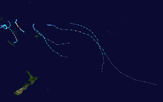
The 2004–05 South Pacific cyclone season was an above-average season in which tropical cyclones formed within the South Pacific Ocean to the east of 160°E. The season officially ran from November 1, 2004 to April 30, 2005, however a tropical cyclone could form at any time between July 1, 2004 and June 30, 2005 and would count towards the season total. The season got off to an early start, when Tropical Depression 01F developed near the Solomon Islands on October 28, three days before the official start of the season. The final disturbance of the season dissipated as the season was drawing to a close on May 1. The season was above-average in terms of activity, with 9 tropical cyclones and 5 severe tropical cyclones forming during the season. The season featured Cyclone Percy, the most intense of the season in terms of pressure.

The 2008–09 South Pacific cyclone season was a below average tropical cyclone season, which featured six named tropical cyclones compared to an average of about nine. Ahead of the season officially starting on November 1, 2008, the Island Climate Update tropical cyclone outlook predicted that the season, would feature an average risk of tropical cyclones impacting the South Pacific between 160°E and 120°W. The first tropical disturbance of the season developed to the northeast of the Samoan Islands on December 1, however, it remained weak and was last noted during the next day.

The 2009–10 South Pacific cyclone season began on December 3, 2009 with the formation of Tropical Disturbance 01F, 32 days after the cyclone season had officially begun on November 1, 2009. The season ended on April 30, 2010. These dates conventionally delimit the period of each year when most tropical cyclones form in the southern Pacific Ocean east of 160°E. Additionally, the regional tropical cyclone operational plan defines a tropical cyclone year separately from a tropical cyclone season; the "tropical cyclone year" began on July 1, 2009 and ended on June 30, 2010. Tropical cyclones between 160°E and 120°W and north of 25°S are monitored by the Fiji Meteorological Service. Those that move south of 25°S are monitored by the Tropical Cyclone Warning Centre in Wellington, New Zealand. The first tropical disturbance of the season formed on December 3, about 1015 km (700 mi) to the north of Suva, Fiji and later intensified into Tropical Cyclone Mick. The last system, 15F, dissipated on April 5 of the following year.

The 1992–93 South Pacific cyclone season was an above-average tropical cyclone season with ten tropical cyclones occurring within the South Pacific to the east of 160°E. The season officially ran from November 1, 1992, to April 30, 1993, with the first disturbance of the season forming on December 3 and the last disturbance dissipating on April 6.

The 2012–13 South Pacific cyclone season was a below average tropical cyclone season, with five tropical cyclones occurring within the basin between 160°E and 120°W. The season officially ran from November 1, 2012, to April 30, 2013, however the last tropical disturbance was last noted on May 1, as it moved into the subtropics. During the season, tropical cyclones were officially monitored by the Fiji Meteorological Service (FMS), Australian Bureau of Meteorology (BoM) and New Zealand's MetService. The United States Joint Typhoon Warning Center (JTWC) and other national meteorological services including Météo-France and NOAA also monitored the basin during the season. During the season there were 22 significant tropical disturbances assigned a number and a F suffix by the FMS's Regional Specialized Meteorological Center in Nadi, Fiji (RSMC Nadi), including Severe Tropical Cyclone Sandra which moved into the basin from the Australian region on March 9. The BoM, MetService and RSMC Nadi all estimated sustained wind speeds over a period of 10-minutes and used the Australian tropical cyclone intensity scale, while the JTWC estimated sustained winds over a 1-minute period, which are subsequently compared to the Saffir–Simpson hurricane wind scale (SSHS).

The 2013–14 South Pacific cyclone season was a slightly below average tropical cyclone season, with six tropical cyclones occurring within the basin between 160°E and 120°W. The season ran from November 1, 2013, to April 30, 2014, however, the first four tropical disturbances occurred during October 2013 and were included as a part of the season. During the season, tropical cyclones were officially monitored by the Fiji Meteorological Service (FMS), Australian Bureau of Meteorology (BoM) and New Zealand's MetService. The United States Joint Typhoon Warning Center (JTWC) and other national meteorological services including Météo-France and NOAA also monitored the basin during the season. During the season there were 21 significant tropical disturbances were assigned a number and an "F" suffix by the FMS's Regional Specialized Meteorological Center in Nadi, Fiji (RSMC Nadi), including the remnants of Tropical Cyclone Hadi from the Australian region. The BoM, MetService and RSMC Nadi all estimated sustained wind speeds over a period of 10-minutes and used the Australian tropical cyclone intensity scale, while the JTWC estimated sustained winds over a 1-minute period, which are subsequently compared to the Saffir–Simpson hurricane wind scale (SSHS).

Severe Tropical Cyclone Joni was a damaging tropical cyclone that impacted the island nations of Tuvalu and Fiji. It was first noted within the South Pacific Convergence Zone at the start of December 1992, as a shallow tropical depression in the vicinity of the island nation Tuvalu. Over the next few days the system gradually developed further as it affected Tuvalu, before it was declared to be a tropical cyclone and named Joni by the Fiji Meteorological Service (FMS) during December 7. Over the next couple of days the system intensified further as it was steered south-westwards and posed a threat towards the Fijian dependency of Rotuma and the French territory of Wallis and Futuna. The system subsequently peaked as a Category 4 severe tropical cyclone on the Australian tropical cyclone intensity scale as it approached the Fijian Islands during December 10. Over the next couple of days the system moved through the Fijian Islands, before it became an extratropical cyclone during December 13. The system was last noted during the next day as it was absorbed by a mid-latitude trough of low pressure to the east of New Zealand.

The 2014–15 South Pacific cyclone season was a slightly-below average tropical cyclone season, with five tropical cyclones occurring within the basin between 160°E and 120°W. The season officially ran from November 1, 2014, to April 30, 2015. During the season, tropical cyclones were officially monitored by the Regional Specialized Meteorological Center (RSMC) in Nadi, Fiji and the Tropical Cyclone Warning Centers in Brisbane, Australia and Wellington, New Zealand. The United States Armed Forces through the Joint Typhoon Warning Center (JTWC) also monitored the basin and issued unofficial warnings for American interests. RSMC Nadi attaches a number and an F suffix to tropical disturbances that form in or move into the basin while the JTWC designates significant tropical cyclones with a number and a P suffix. RSMC Nadi, TCWC Wellington and TCWC Brisbane all use the Australian Tropical Cyclone Intensity Scale and estimate windspeeds over a period of ten minutes, while the JTWC estimated sustained winds over a 1-minute period, which are subsequently compared to the Saffir–Simpson hurricane wind scale (SSHWS).

Severe Tropical Cyclone Sina was the only named tropical cyclone to develop within the South Pacific basin during the 1990–91 season. The system was first noted as a shallow depression within the South Pacific Convergence Zone to the west of Wallis Island. Over the next three days the system moved towards the west-northwest, before it was named Sina during November 24, after it had developed into a tropical cyclone. Over the next couple of days the system intensified further and developed an eye feature as it erratically moved towards Fiji. Sina subsequently peaked in intensity during November 26, before the system passed through the Fijian Islands over the next two days as it started to gradually weaken. Sina subsequently passed just to the north of Tongatapu in Tonga during November 29, before it passed about 160 km (100 mi) to the south of Niue and near the Southern Cook Islands during the next day. The system subsequently rapidly weakened and became an extratropical cyclone during December 1, before they were absorbed by an advancing trough of low pressure near 50°S on December 4.

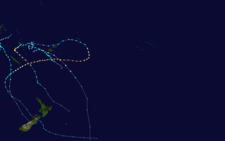
The 2015–16 South Pacific cyclone season was one of the most disastrous South Pacific tropical cyclone seasons on record, with a total of 50 deaths and $1.405 billion in damage. Throughout the season, 8 systems attained tropical cyclone status, whilst 5 became severe tropical cyclones. The most notable cyclone of the season by far was Winston, which attained a minimum pressure of 884 hPa, and maximum ten-minute sustained winds of 175 mph (280 km/h), making it the most intense tropical cyclone on record in the Southern Hemisphere. Winston went on to devastate Fiji, causing $1.4 billion in damage and 44 deaths across the country.

The 2016–17 South Pacific cyclone season was the least active South Pacific cyclone season since the 2011–12 season, with only four tropical cyclones occurring within the South Pacific Ocean to the east of 160°E. Two of the four systems developed into severe tropical cyclones on the Australian tropical cyclone intensity scale. The season officially ran from November 1, 2016 until April 30, 2017. However, May featured two post-season systems: Donna and Ella, of which the former was the strongest post-season South Pacific tropical cyclone ever recorded in that month. Overall, 22 tropical disturbances were monitored by a combination of the Fiji Meteorological Service (FMS), Australian Bureau of Meteorology (BoM) and New Zealand's MetService.
The 2017–18 South Pacific cyclone season was a slightly below-average season that produced 6 tropical cyclones, 3 of which became severe tropical cyclones. The season officially began on November 1, 2017, and ended on April 30, 2018; however, a tropical cyclone could form at any time between July 1, 2017, and June 30, 2018, and would count towards the season total. During the season, tropical cyclones were officially monitored by the Fiji Meteorological Service, MetService and the Australian Bureau of Meteorology, while the United States Joint Typhoon Warning Center (JTWC) also monitored the basin and issued warnings for American interests. The FMS attaches a number and an F suffix to significant tropical disturbances that form in or move into the basin, while the JTWC designates significant tropical cyclones with a number and a P suffix. The BoM, FMS and MetService all use the Australian Tropical Cyclone Intensity Scale and estimate wind speeds over a period of ten minutes, while the JTWC estimates sustained winds over a 1-minute period, which are subsequently compared to the Saffir–Simpson hurricane wind scale (SSHWS).

The 2018–19 South Pacific cyclone season was a below-average season that produced 5 tropical cyclones, 2 of which became severe tropical cyclones. The season officially runs from November 1, 2018, to April 30, 2019; however, a tropical cyclone could have formed at any time between July 1, 2018, and June 30, 2019, and would count towards the season total. During the season, tropical cyclones were officially monitored by the Fiji Meteorological Service, Australian Bureau of Meteorology, and New Zealand's MetService. The United States Armed Forces through the Joint Typhoon Warning Center (JTWC) also monitored the basin and issued warnings for American interests. RSMC Nadi attaches a number and an F suffix to tropical disturbances that form in or move into the basin, while the JTWC designates significant tropical cyclones with a number and a P suffix. The FMS, the BoM and MetService all use the Australian Tropical Cyclone Intensity Scale and estimate wind speeds over a period of ten minutes, while the JTWC estimates sustained winds over a 1-minute period, which are subsequently compared to the Saffir–Simpson hurricane wind scale (SSHWS).

The 2019–20 South Pacific cyclone season was a slightly above-average season in which tropical cyclones formed within the South Pacific Ocean to the east of 160°E. The season officially ran from November 1, 2019, to April 30, 2020, however a tropical cyclone could form at any time between July 1, 2019, and June 30, 2020, and would count towards the season total. The season began on November 22 with the formation of Tropical Cyclone Rita, which would later become a severe tropical cyclone. The season has been near-average in terms of activity, with 8 tropical cyclones and 4 severe tropical cyclones forming during the season. The season featured Cyclone Harold, the first Category 5 severe tropical cyclone in the basin since Cyclone Gita, and one of the strongest since Cyclone Winston. During the season, tropical cyclones are officially monitored by the Fiji Meteorological Service (FMS), Australian Bureau of Meteorology (BOM) and New Zealand's MetService. The United States Armed Forces through the Joint Typhoon Warning Center (JTWC) also monitors the basin and issue unofficial warnings for American interests. The FMS attaches a number and an F suffix to tropical disturbances that form in or move into the basin while the JTWC designates significant tropical cyclones with a number and a P suffix. The FMS, BoM and MetService all use the Australian Tropical Cyclone Intensity Scale and estimate wind speeds over a period of ten minutes, while the JTWC estimated sustained winds over a 1-minute period, which are subsequently compared to the Saffir–Simpson hurricane wind scale (SSHWS).

Severe Tropical Cyclone Bebe, also known as Hurricane Bebe, was a pre-season storm during October 1972 in the South Pacific Ocean that severely affected Fiji, the Ellice Islands, and the Gilbert Islands.
The following is a list of all reported tropical cyclones within the South Pacific Ocean to the east of 160°E after the start of World War II in September 1939 and before the start of the 1950s decade.

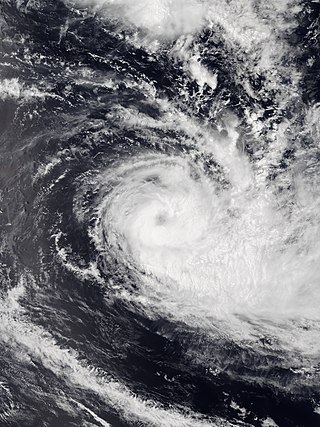
Severe Tropical Cyclone Tino was a tropical cyclone which itself and an associated convergence zone caused significant damage across ten island nations in the South Pacific Ocean during January 2020. First noted as a tropical disturbance during January 11, to the southwest of Honiara in the Solomon Islands, the system gradually developed over the next few days as it moved eastwards in between the Solomon Islands and Vanuatu prior to being named Tino as it approached Fiji during January 16. Continuing to track south-eastward, Tino continued strengthening as it passed near Fiji, bringing copious amounts of rainfall to the area. Whilst losing latitude, the system continued to strengthen and peaked as a category 3 tropical cyclone on January 17, with signs of an eye forming. Shortly after peak intensity, Tino was impacted by high wind shear and decreasing sea surface temperatures, triggering a weakening trend. Tino moved out of the tropics shortly thereafter and became an extratropical cyclone during January 19.
Tropical Cyclone Sarai was a moderately strong tropical cyclone that impacted several island nations and countries in late-December 2019. The third tropical cyclone and the second named storm of the 2019-20 South Pacific cyclone season, Sarai formed from an area of low pressure to the south of Tuvalu. Over the next days, the low pressure became organized and was designated by the Fiji Meteorological Service as Tropical Disturbance 03F on December 23. Under favorable conditions, the disturbance gradually organized, becoming a depression two days later, before strengthening to a tropical cyclone, earning the name Sarai. It moved to the south, before a high-pressure steered the system to the east, passing to the south of Fiji, near Suva before weakening. Sarai passed near the Tongan islands of Haʻapai and Tongatapu as a Category 1 cyclone, before rapidly degrading to a tropical depression due to the system entering unfavorable conditions. It was last noted on January 2 to the southeast of Cook Islands.

