This timeline of volcanism on Earth includes a list of major volcanic eruptions of approximately at least magnitude 6 on the Volcanic explosivity index (VEI) or equivalent sulfur dioxide emission during the Quaternary period (from 2.58 Mya to the present). Other volcanic eruptions are also listed.
Some eruptions cooled the global climate—inducing a volcanic winter—depending on the amount of sulfur dioxide emitted and the magnitude of the eruption. [1] [2] Before the present Holocene epoch, the criteria are less strict because of scarce data availability, partly since later eruptions have destroyed the evidence. Only some eruptions before the Neogene period (from 23 Mya to 2.58 Mya) are listed. Known large eruptions after the Paleogene period (from 66 Mya to 23 Mya) are listed, especially those relating to the Yellowstone hotspot, Santorini caldera, and the Taupō Volcanic Zone.
Active volcanoes such as Stromboli, Mount Etna and Kīlauea do not appear on this list, but some back-arc basin volcanoes that generated calderas do appear. Some dangerous volcanoes in "populated areas" appear many times: Santorini six times, and Yellowstone hotspot 21 times. The Bismarck volcanic arc, New Britain, and the Taupō Volcanic Zone, New Zealand, appear often too.
In addition to the events listed below, there are many examples of eruptions in the Holocene on the Kamchatka Peninsula, [3] which are described in a supplemental table by Peter Ward. [4]
The Holocene epoch begins 11,700 years BP (10,000 14C years ago). [5]
This is a sortable summary of 27 major eruptions in the last 2000 years with VEI ≥6, implying an average of about 1.3 per century. The count does not include the notable VEI 5 eruptions of Mount St. Helens and Mount Vesuvius. Date uncertainties, tephra volumes, and references are also not included.
Caldera/ Eruption name | Volcanic arc/ belt or Subregion or Hotspot | VEI | Date | Known/proposed consequences |
---|---|---|---|---|
Mount Pinatubo | Luzon Volcanic Arc | 6 | 1991, Jun 15 | Global temperature fell by 0.4 °C |
Novarupta | Aleutian Range | 6 | 1912, Jun 6 | |
Santa María | Central America Volcanic Arc | 6 | 1902, Oct 24 | |
Krakatoa | Sunda Arc | 6 | 1883, Aug 26–27 | At least 30,000 dead |
Mount Tambora | Lesser Sunda Islands | 7 | 1815, Apr 10 | Year Without a Summer (1816) |
1808 mystery eruption | Southwestern Pacific Ocean | 6 | 1808, Dec | A sulfate spike in ice cores |
Long Island (Papua New Guinea) | Bismarck Volcanic Arc | 6 | 1660 | |
Huaynaputina | Andes, Central Volcanic Zone | 6 | 1600, Feb 19 | Russian famine of 1601–1603 |
Billy Mitchell | Bougainville & Solomon Is. | 6 | 1580 | |
Bárðarbunga | Iceland | 6 | 1477 | |
1458 mystery eruption | unknown | 6-7 | 1458 | Possibly larger than Mount Tambora's |
1452/1453 mystery eruption | Unknown | 6-7 | 1452–53 | 2nd pulse [27] of Little Ice Age? |
Quilotoa | Andes, Northern Volcanic Zone | 6 | 1280 | |
Samalas (Mount Rinjani) | Lombok, Lesser Sunda Islands | 7 | 1257 | 1257 Samalas eruption, 1st pulse [28] [29] of Little Ice Age? (c.1250) |
Baekdu Mountain/Tianchi eruption | China/ North Korea border | 7 | 946, Nov-947 | Limited regional climatic effects. [30] |
Ceboruco | Trans-Mexican Volcanic Belt | 6 | 930 | |
Dakataua | Bismarck Volcanic Arc | 6 | 800 | |
Pago | Bismarck Volcanic Arc | 6 | 710 | |
Mount Churchill | eastern Alaska, USA | 6 | 700 | |
Rabaul caldera | Bismarck Volcanic Arc | 6 | 683 (est.) | |
Volcanic winter of 536 | Krakatoa | 6-7 | 535 | |
Ilopango | Central America Volcanic Arc | 6 | 450 | |
Ksudach | Kamchatka Peninsula | 6 | 240 | |
Taupō Caldera/Hatepe eruption | Taupō Volcano | 7 | 180 or 230 | Affected skies over Rome and China |
Mount Churchill | eastern Alaska, USA | 6 | 60 | |
Ambrym | New Hebrides Arc | 6 | 50 | |
Apoyeque | Central America Volcanic Arc | 6 | 50 BC (±100) | |
Note: Caldera names tend to change over time. For example, Ōkataina Caldera, Haroharo Caldera, Haroharo volcanic complex, and Tarawera volcanic complex all had the same magma source in the Taupō Volcanic Zone. Yellowstone Caldera, Henry's Fork Caldera, Island Park Caldera, Heise Volcanic Field all had Yellowstone hotspot as magma source.
2.588 ± 0.005 million years BP, the Quaternary period and Pleistocene epoch begin.
Approximately 5.332 million years BP, the Pliocene epoch begins. Most eruptions before the Quaternary period have an unknown VEI.
Approximately 23.03 million years BP, the Neogene period and Miocene epoch begin.
VEI | Tephra Volume (cubic kilometers) | Example |
---|---|---|
0 | Effusive | Masaya Volcano, Nicaragua, 1570 |
1 | >0.00001 | Poás Volcano, Costa Rica, 1991 |
2 | >0.001 | Mount Ruapehu, New Zealand, 1971 |
3 | >0.01 | Nevado del Ruiz, Colombia, 1985 |
4 | >0.1 | Eyjafjallajökull, Iceland, 2010 |
5 | >1 | Mount St. Helens, United States, 1980 |
6 | >10 | Mount Pinatubo, Philippines, 1991 |
7 | >100 | Mount Tambora, Indonesia, 1815 |
8 | >1000 | Yellowstone Caldera, United States, Pleistocene |
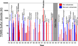
The global dimming through volcanism (ash aerosol and sulfur dioxide) is quite independent of the eruption VEI. [104] [105] [106] When sulfur dioxide (boiling point at standard state: -10 °C) reacts with water vapor, it creates sulfate ions (the precursors to sulfuric acid), which are very reflective; ash aerosol on the other hand absorbs ultraviolet. [107] Global cooling through volcanism is the sum of the influence of the global dimming and the influence of the high albedo of the deposited ash layer. [108] The lower snow line and its higher albedo might prolong this cooling period. [109] Bipolar comparison showed six sulfate events: Tambora (1815), Cosigüina (1835), Krakatoa (1883), Agung (1963), and El Chichón (1982), and the 1808 mystery eruption. [110] And the atmospheric transmission of direct solar radiation data from the Mauna Loa Observatory (MLO), Hawaii (19°32'N) detected only five eruptions: [111]
But very large sulfur dioxide emissions overdrive the oxidizing capacity of the atmosphere. Carbon monoxide's and methane's concentration goes up (greenhouse gases), global temperature goes up, ocean's temperature goes up, and ocean's carbon dioxide solubility goes down. [1]
A caldera is a large cauldron-like hollow that forms shortly after the emptying of a magma chamber in a volcanic eruption. An eruption that ejects large volumes of magma over a short period of time can cause significant detriment to the structural integrity of such a chamber, greatly diminishing its capacity to support its own roof, and any substrate or rock resting above. The ground surface then collapses into the emptied or partially emptied magma chamber, leaving a large depression at the surface. Although sometimes described as a crater, the feature is actually a type of sinkhole, as it is formed through subsidence and collapse rather than an explosion or impact. Compared to the thousands of volcanic eruptions that occur over the course of a century, the formation of a caldera is a rare event, occurring only a few times within a given window of 100 years. Only eight caldera-forming collapses are known to have occurred between 1911 and 2018, with a caldera collapse at Kīlauea, Hawaii in 2018. Volcanoes that have formed a caldera are sometimes described as "caldera volcanoes".
Lake Toba is a large natural lake in North Sumatra, Indonesia, occupying the caldera of the Toba supervolcano. The lake is located in the middle of the northern part of the island of Sumatra, with a surface elevation of about 900 metres (2,953 ft), the lake stretches from 2.88°N 98.52°E to 2.35°N 99.1°E. The lake is about 100 kilometres long, 30 kilometres (19 mi) wide, and up to 505 metres (1,657 ft) deep. It is the largest lake in Indonesia and the largest volcanic lake in the world. Toba Caldera is one of twenty geoparks in Indonesia, and was recognised in July 2020 as one of the UNESCO Global Geoparks.
A supervolcano is a volcano that has had an eruption with a volcanic explosivity index (VEI) of 8, the largest recorded value on the index. This means the volume of deposits for such an eruption is greater than 1,000 cubic kilometers.
The Taupō Volcanic Zone (TVZ) is a volcanic area in the North Island of New Zealand. It has been active for at least the past two million years and is still highly active.
The Yellowstone Caldera, sometimes referred to as the Yellowstone Supervolcano, is a volcanic caldera and supervolcano in Yellowstone National Park in the Western United States. The caldera and most of the park are located in the northwest corner of the state of Wyoming. The caldera measures 43 by 28 miles, and postcaldera lavas spill out a significant distance beyond the caldera proper.
The Phlegraean Fields is a large caldera volcano west of Naples, Italy. It is part of the Campanian volcanic arc, which includes Mount Vesuvius, about 9 km east of Naples. The Phlegraean Fields is monitored by the Vesuvius Observatory. It was declared a regional park in 2003.
The Snake River Plain is a geologic feature located primarily within the U.S. state of Idaho. It stretches about 400 miles (640 km) westward from northwest of the state of Wyoming to the Idaho-Oregon border. The plain is a wide, flat bow-shaped depression and covers about a quarter of Idaho. Three major volcanic buttes dot the plain east of Arco, the largest being Big Southern Butte.
The Yellowstone hotspot is a volcanic hotspot in the United States responsible for large scale volcanism in Idaho, Montana, Nevada, Oregon, and Wyoming, formed as the North American tectonic plate moved over it. It formed the eastern Snake River Plain through a succession of caldera-forming eruptions. The resulting calderas include the Island Park Caldera, Henry's Fork Caldera, and the Bruneau-Jarbidge caldera. The hotspot currently lies under the Yellowstone Caldera. The hotspot's most recent caldera-forming supereruption, known as the Lava Creek Eruption, took place 640,000 years ago and created the Lava Creek Tuff, and the most recent Yellowstone Caldera. The Yellowstone hotspot is one of a few volcanic hotspots underlying the North American tectonic plate; another example is the Anahim hotspot.
La Garita Caldera is a large caldera and extinct supervolcano in the San Juan volcanic field in the San Juan Mountains around the town of Creede in southwestern Colorado, United States. It is west of La Garita, Colorado. The eruption that created the La Garita Caldera is among the largest known volcanic eruptions in Earth's history, as well as being one of the most powerful known supervolcanic events.
Torfajökull is a rhyolitic stratovolcano, with a large caldera capped by a glacier of the same name and associated with a complex of subglacial volcanoes. Torfajökull last erupted in 1477 and consists of the largest area of silicic extrusive rocks in Iceland. This is now known to be due to a VEI 5 eruption 55,000 years ago.
Aso caldera is a geographical feature of Kumamoto Prefecture, Japan. It stretches 25 kilometers north to south and 18 kilometers east to west. The central core "Aso Gogaku" is the five major mountains in the area. Aso valley (Asodani) runs along the northern base of Mount Aso and Nango valley (Nangodani) along the south. According to research of caldera sediment, lakes used to exist in these valleys. The dried up lake areas have come to be called Old Aso Lake, Kugino Lake, and Aso Valley Lake. The Kikuchi, Shirakawa and Kurokawa rivers now drain the caldera.
The Campanian Ignimbrite eruption was a major volcanic eruption in the Mediterranean during the late Quaternary, classified 7 on the Volcanic Explosivity Index (VEI). The event has been attributed to the Archiflegreo volcano, the 12-by-15-kilometre-wide caldera of the Phlegraean Fields, located 20 km (12 mi) west of Mount Vesuvius under the western outskirts of the city of Naples and the Gulf of Pozzuoli, Italy. It is the largest explosive volcanic event in Europe in the past 200,000 years, and the largest eruption of Campi Fleigrei caldera.
Wah Wah Springs Caldera is a supervolcanic eruption remnant discovered in 2013 in Utah. It released 5,500 to 5,900 cubic kilometres of tephra, as the Wah Wah Springs Tuff, about 30.06 million years ago in the early Oligocene. It is the largest of the Indian Peak-Caliente Caldera Complex, and includes flows over 500 m thick at the most. It is considered one of the largest single explosive eruptions known in Earth's history, and the second most energetic event to have occurred on Earth since the asteroid impact at the end of the Cretaceous period.
Whakamaru Caldera was created in a massive supereruption 335,000 years ago and is approximately 30 by 40 km in size and is located in the North Island of New Zealand. It now contains active geothermal areas as well as the later Maroa Caldera.
The Mangakino caldera complex is the westernmost and one of oldest extinct rhyolitic caldera volcanoes in the Taupō Volcanic Zone of New Zealand's North Island. It produced about a million years ago in the Kidnappers eruption of 1,200 km3 (287.9 cu mi), the most widespread ignimbrite deposits on Earth being over 45,000 km2 (17,000 sq mi) and was closely followed in time by the smaller 200 km3 (48.0 cu mi) Rocky Hill eruption. The Kidnappers eruption had a estimated VEI of 8 and has been assigned a total eruption volume of 2,760 km3 (662.2 cu mi).
The Tauranga Volcanic Centre is a geologic region in New Zealand's Bay of Plenty. It extends from the southern end of Waihi Beach and from the old volcanoes of the Coromandel Peninsula that make up the northern part of the Kaimai Range, towards the Taupō Volcanic Zone.
The Cascade Volcanic Arc is a chain of volcanoes stretching from southern British Columbia down to northern California. Within the arc there is a variety of stratovolcanoes like Mount Rainier and broad shield volcanoes like Medicine Lake. But calderas are very rare in the Cascades, with very few forming over the 39 million year lifespan of the arc.
Much of the volcanic activity in the northern portions of the North Island of New Zealand is recent in geological terms and has taken place over the last 30 million years. This is primarily due to the North Island's position on the boundary between the Indo-Australian and Pacific Plates, a part of the Pacific Ring of Fire, and particularly the subduction of the Pacific Plate under the Indo-Australian Plate. The activity has included some of the world's largest eruptions in geologically recent times and has resulted in much of the surface formations of the North Island being volcanic as shown in the map.
{{cite book}}
: |website=
ignored (help){{cite web}}
: Missing or empty |title=
(help){{cite journal}}
: CS1 maint: multiple names: authors list (link)