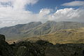
Scafells | |
---|---|
Highest point | |
Elevation | max. 978 m (3,209 ft) at Scafell Pike |
Coordinates | 54°28′16″N3°08′38″W / 54.471°N 3.144°W |
Geography | |
Parent range | Cumbrian Mountains |
Geology | |
Age of rock | - |
Mountain type | Caldera |
Last eruption | - |
The Scafells, or Scafell Massif, [1] are range of fells in the Cumbrian Mountains of England, made up of the remains of a caldera volcano. Fells in the range include Broad Crag, Ill Crag, Scafell, and Scafell Pike, England's tallest mountain. Great End, Lingmell and Slight Side are also usually included within the definition. These hills form part of the Southern Fells.
Geologically, the Scafells are the remnants of a volcano that erupted in the Ordovician period over 400 million years ago. This volcano, geologically described as a caldera and an "inverse stratovolcano", as well as all other volcanoes of the Lake District, are long since extinct. [2]
The volcano is an example of a piecemeal caldera whose collapse, in contrast with a wholesale piston-like subsidence, occurred in a piece-by-piece fashion along faults and whose measurements suggest formation from an eruption of a VEI-7 magnitude, comparable to the Minoan eruption at Santorini in the Greek Aegean in c. 1600 BCE. The Scafell Dacite, between Little Narrowcove and Aaron Crags, is a lava dome formed during the last stages of volcanic activity at Scafells. [2]
An English Munro (or Furth) is a mountain summit that exceeds 3,000 feet (914.4 m) and has a prominence of more than 30 metres (98 feet). In England there are six peaks that meet that criteria and four of those are part of the Scafell Massif. [lower-alpha 1]
Peak | Area | Height (m) | Prominence (m) | OSI Grid Reference | Highest Class | |
---|---|---|---|---|---|---|
Scafell Pike‡ | Scafell Massif | 978 | 912 | NY215072 | P600 | |
Sca Fell | Scafell Massif | 964 | 133 | NY207065 | Hewitt | |
Helvellyn‡ | Helvellyn range | 950 | 712 | NY342151 | P600 | |
Ill Crag | Scafell Massif | 935 | 57 | NY223073 | Hewitt | |
Broad Crag | Scafell Massif | 934 | 52 | NY218075 | Hewitt | |
Skiddaw‡ | Northern Fells | 931 | 709 | NY260290 | P600 |
(‡) Have the prominence of over 150 metres (492 ft) to qualify as a "Real Munro".
The summit of Scafell (964 m) is only 14 m lower than Scafell Pike (978 m); it can sometimes appear to be higher because of its precipitous topography.
The traverse between England's two highest summit's via Mickledore col requires considerable care and caution:
. . ."Broad Stand is an extremely dangerous area which has unfortunately seen a number of fatalities. [3]
In England and Wales the mountain rescue association advise that a traditional paper map should always be carried in case of:
How to navigate with your phone
..."Carry a paper map as backup...While digital mapping is incredibly convenient, technology can occasionally fail... [4]
Mountain rescue in England and Wales – August 2023
Scafell Pike is a mountain in the Lake District region of Cumbria, England. It has an elevation of 978 metres (3,209 ft) above sea level, making it the highest and the most prominent mountain in England. The mountain is part of the Scafell massif, an inactive volcano, and is one of the Southern Fells.
Scafell is a mountain in the Lake District region of Cumbria, England. It has a height of 964 metres, making it the second-highest mountain in England after its neighbour, Scafell Pike, from which it is separated by Mickledore col.
Mickledore is a narrow ridge, 840 metres (2755 ft) high, connecting the mountains of Scafell and Scafell Pike in the English Lake District. It is also a pass between the valleys of Wasdale and Eskdale.
Helvellyn is a mountain in the English Lake District, the highest point of the Helvellyn range, a north–south line of mountains to the north of Ambleside, between the lakes of Thirlmere and Ullswater.
Pillar is a mountain in the western part of the English Lake District. Situated between the valleys of Ennerdale to the north and Wasdale to the south, it is the highest point of the Pillar group. At 892 metres (2,927 ft) it is the eighth-highest mountain in the Lake District. The fell takes its name from Pillar Rock, a prominent feature on the Ennerdale side, regarded as the birthplace of rock climbing in the district.
Great Gable is a mountain in the Lake District, United Kingdom. It is named after its appearance as a pyramid from Wasdale, though it is dome-shaped from most other directions. It is one of the most popular of the Lakeland fells, and there are many different routes to the summit. Great Gable is linked by the high pass of Windy Gap to its smaller sister hill, Green Gable, and by the lower pass of Beck Head to its western neighbour, Kirk Fell.
Great End is the most northerly mountain in the Scafell chain, in the English Lake District. From the south it is simply a lump continuing this chain. From the north, however, it appears as an immense mountain, with an imposing north face rising above Sprinkling Tarn (lake). This is a popular location for wild camping, and the north face attracts many climbers.
Esk Pike is a fell in the English Lake District, one of the cirque of hills forming the head of Eskdale.
Buckbarrow is a small fell in the English Lake District overlooking the western end of Wastwater. It is featured in Alfred Wainwright’s Pictorial Guide to the Lakeland Fells and is given a height of 1,410 ft approximately; however, the Ordnance Survey and other guidebooks now give an altitude of 423 m (1,388 ft). The fell’s name means ‘The hill of the buck or goat’. It is derived either from the Old English word bucc meaning buck or the Old Norse word bokki meaning a male goat.
Kirk Fell is a fell in the Western part of the English Lake District. It is situated between Great Gable and Pillar on the long ring of fells surrounding the valley of Ennerdale, and also stands over Wasdale to the south. However, it is separated from its two higher neighbours by the low passes of Black Sail and Beck Head, giving it a high relative height and making it a Marilyn, the thirteenth highest in the Lake District.
Seatallan is a mountain in the western part of the English Lake District. It is rounded, grassy and fairly unassuming, occupying a large amount of land. However, it is classed as a Marilyn because of the low elevation of the col connecting it to Haycock, its nearest higher neighbour to the north. The name Seatallan is believed to have a Cumbric origin, meaning "Aleyn's high pasture".
Seathwaite Fell is an area of the Lake District in Cumbria, England. It stands above the hamlet of the same name at the head of Borrowdale.
Red Pike is a fell in the High Stile range in the western English Lake District, which separates Ennerdale from the valley of Buttermere and Crummock Water. It is 2,476 ft (755 m) high. The direct ascent of Red Pike from Buttermere is very popular and the ridge walk from Red Pike to Haystacks is regarded as one of the finest in the area, with excellent views of the Scafells, Great Gable and Pillar.
Red Pike is a fell in the English Lake District. It is 826 m or 2,709 ft high and lies due north of Wast Water. It is often climbed as part of the Mosedale Horseshoe, a walk which also includes Pillar.
Lingmell is a fell in the English Lake District, standing above the village of Wasdale Head. It is an outlier on the north-west flank of Scafell Pike, England’s highest mountain.
Yewbarrow is a fell, in the English Lake District, which lies immediately north of the head of Wast Water. It is 628 metres high and in shape resembles the upturned hull of a boat or a barrow. Yewbarrow is on the left in the classic view of Great Gable and Wast Water.
Haycock is a mountain in the western part of the English Lake District. It rises between Scoat Fell and Caw Fell to the south of Ennerdale and the north of Wasdale. Haycock is an imposing dome-shaped fell, its popularity with walkers diminished somewhat by its remoteness. It can be climbed from either valley and offers fine mountain views.
Slight Side is a fell in the English Lake District it stands 25 kilometres east southeast of the town of Whitehaven and reaches a height of 762 metres (2,499 ft). Slight Side lies at the south western edge of the Scafell Massif, a four-kilometre-long crescent of high ground which includes the highest ground in England. The fells names derives from the Old Norse language and means "The mountain shieling with the level pastures", it is a combination of the Norse words "sletta" and "saetr". With a shieling meaning a shepherds hut or a mountain pasture used in the summer.
Rossett Pike is a fell in the English Lake District. It is located at the head of Mickleden, one of two tributary valleys of Great Langdale.
The Southern Fells are a part of the Cumbrian Mountains in the Lake District of England. Including Scafell Pike, the highest peak in England, they occupy a broad area to the south of Great Langdale, Borrowdale and Wasdale. High and rocky towards the centre of the Lake District, the Southern Fells progressively take on a moorland character toward the south-west. In the south-east are the well-known Furness Fells, their heavily quarried flanks rising above Coniston Water.