The Shoshone or Shoshoni are a Native American tribe with four large cultural/linguistic divisions:

The Humboldt River is an extensive river drainage system located in north-central Nevada. It extends in a general east-to-west direction from its headwaters in the Jarbidge, Independence, and Ruby Mountains in Elko County, to its terminus in the Humboldt Sink, approximately 225 direct miles away in northwest Churchill County. Most estimates put the Humboldt River at 300 miles (480 km) to 330 miles (530 km) long however, due to the extensive meandering nature of the river, its length may be more closely estimated at 380 miles (612 km). It is located within the Great Basin Watershed and is the third longest river in the watershed behind the Bear River at 355 miles (570 km) and the Sevier River at 325 miles (523 km). The Humboldt River Basin is the largest sub-basin of the Great Basin encompassing an area of 16,840 square miles (43,615 km2). It is the only major river system wholly contained within the state of Nevada.
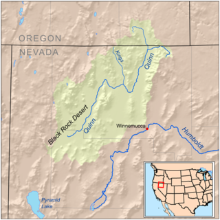
The Kings River is a tributary of the Quinn River, about 40 mi (64 km) long, in northwestern Nevada and south-central Oregon in the United States. It drains a remote arid area of the northwestern Great Basin.

Bishop Creek is a 10.1-mile-long (16.3 km) stream in Inyo County, California. It is the largest tributary of the Owens River. It has five hydroelectric plants owned by Southern California Edison, Bishop Creek #2–6. Bishop Creek #1 was never completed. Parts of the creek run through pipelines, or penstocks, to increase output at the power plants.

The Cherry Creek Range is a line of mountains, Basin and Range faulted, in northern White Pine and southern Elko Counties, in northeastern Nevada in the western United States. The range runs generally north–south for approximately 50 miles (80 km). The highest point in the range is an unnamed peak, located just south of the border between the counties.

Big Chico Creek is a creek in northeastern California that originates near Colby Mountain in Lassen National Park. It flows 46 miles (74 km) to its confluence with the Sacramento River in Butte County. The creek's elevation declines from 5,000 feet (1,500 m) above sea level at its head to 120 feet (37 m) where it joins the Sacramento River, as shown on the Ord Ferry USGS quadrangle. Big Chico Creek forms part of the demarcation between the Sierra Nevada and the Cascade Range.

State Route 140 is a two-lane state highway in Humboldt County, Nevada. It serves a sparsely populated section of the state, connecting northwestern Nevada to southern Oregon. Most of the highway was originally part of State Route 8A, and was later improved through an effort to provide an all-weather highway linking northern Nevada to the Pacific Northwest.

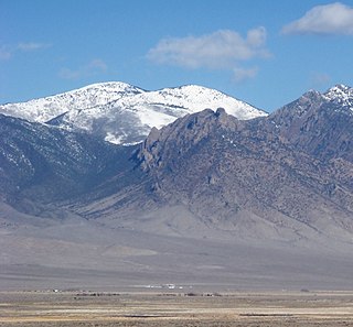
North Schell Peak is the highest mountain in the Schell Creek Range of White Pine County, Nevada, United States. It is the ninth-highest mountain in the state, and also ranks as the fifth-most topographically prominent peak in the state. The summit is 19 miles (31 km) northeast of the community of Ely within the High Schells Wilderness of the Humboldt-Toiyabe National Forest.
Satview Broadband is a cable television Multiple System Operator in the United States, with franchise cable television systems in the State of Nevada. Satview offers Video, High-Speed Internet and Telephone Service in Topaz Lake, Wells and Carlin Nevada. Its systems in Battle Mountain, Elko were sold to Zito Media. Its systems in Colorado and New Mexico were divested in 2015. The operator serves mainly rural towns and cities. It has cable franchises in Elko and Douglas, counties in Nevada.
The Jackson Mountains are a north-northeast trending mountain range in southwestern Humboldt County, Nevada. The range is flanked on the west by the Black Rock Desert and the Black Rock Range beyond. To the north across the Quinn River and Nevada State Route 140 lie the Bilk Creek Mountains. To the northeast across Kings River Valley is the Double Mountains and to the east are the Sleeping Hills. To the southeast and south lie the Eugene and Kamma Mountains. The ghost town of Sulphur lies just southwest of the pass between the Jackson and Kamma ranges. Nevada State Route 49 and the Union Pacific railroad Feather River Route traverse this pass.
The Smoke Creek Mountains is a mountain range in Washoe County, Nevada at the California border, west of the Smoke Creek Desert.
The White Rock Mountains are a north-northwest trending mountain range located in eastern Lincoln County, Nevada with the eastern slopes of the range extending into Beaver and Iron counties of Utah. The north end of the range merges with the Wilson Creek Range on the west.

The Fox Creek Range is a mountain range in Elko County, Nevada, United States. It is mostly contained within the Jarbidge Ranger District of the Humboldt-Toiyabe National Forest. The range is considered to be a sub-range of the Jarbidge Mountains.
The Augusta Mountains are a small mountain range in Pershing, Churchill and Lander counties of Nevada.

The Copper Mountains are a mountain range in Elko County, Nevada, United States.
The Kern Mountains are a mountain range primarily on the eastern edge of White Pine County, Nevada, United States, but extending slightly east into western Juab County, Utah.

The Trout Creek Mountains are a remote, semi-arid Great Basin mountain range mostly in southeastern Oregon and partially in northern Nevada in the United States. The range's highest point is Orevada View Benchmark, 8,506 feet (2,593 m) above sea level, in Nevada. Disaster Peak, elevation 7,781 feet (2,372 m), is another prominent summit in the Nevada portion of the mountains.
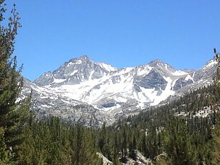
Bear Creek Spire is a mountain in the Sierra Nevada in Inyo County, California, in the western United States, and is the 46th highest mountain in California and the 225th highest mountain in the United States. Bear Creek Spire is part of the John Muir Wilderness and the Inyo National Forest.
Ibapah Peak is a 12,087-foot (3,684 m) summit in Juab County, Utah in the United States. It is the highest point of the Deep Creek Range and is located less than 5 miles (8.0 km) east of the Utah-Nevada border, and about 10 miles (16 km) northwest of the town of Trout Creek, Utah. With a topographic prominence of 5,247 feet (1,599 m) it is the eighth-most prominent summit in Utah.
