The Sierra Nevada is a mountain range in the Western United States, between the Central Valley of California and the Great Basin. The vast majority of the range lies in the state of California, although the Carson Range spur lies primarily in Nevada. The Sierra Nevada is part of the American Cordillera, an almost continuous chain of mountain ranges that forms the western "backbone" of the Americas.

White Pine County is a largely rural, mountain county along the central eastern boundary of the U.S. state of Nevada. As of the 2010 census, the population was 10,030. Its county seat is Ely. The name "(Rocky Mountain) white pine" is an old name for the limber pine, a common tree in the county's mountains.

The term bristlecone pine covers three species of pine tree. All three species are long-lived and highly resilient to harsh weather and bad soils. One of the three species, Pinus longaeva, is among the longest-lived life forms on Earth. The oldest of this species is more than 4,800 years old, making it the oldest known individual of any species.

The Humboldt–Toiyabe National Forest (HTNF) is the principal U.S. National Forest in the U.S. state of Nevada, and has a smaller portion in Eastern California. With an area of 6,289,821 acres (25,454.00 km2), it is the largest U.S. National Forest outside Alaska.

The White Mountains of California and Nevada are a triangular fault-block mountain range facing the Sierra Nevada across the upper Owens Valley. They extend for approximately 60 mi (97 km) as a greatly elevated plateau about 20 mi (32 km) wide on the south, narrowing to a point at the north, with elevations generally increasing south to north. The range's broad southern end is near the community of Big Pine, where Westgard Pass and Deep Springs Valley separate it from the Inyo Mountains. The narrow northern end is at Montgomery Pass, where U.S. Route 6 crosses. The Fish Lake Valley lies east of the range; the southeast part of the mountains are separated from the Silver Peak Range by block faulting across the Furnace Creek Fault Zone, forming a feeder valley to Fish Lake Valley. The range lies within the eastern section of the Inyo National Forest.

Pinus flexilis, the limber pine, is a species of pine tree-the family Pinaceae that occurs in the mountains of the Western United States, Mexico, and Canada. It is also called Rocky Mountain white pine.

Pinus ponderosa, commonly known as the ponderosa pine, bull pine, blackjack pine, western yellow-pine, or filipinus pine is a very large pine tree species of variable habitat native to mountainous regions of western North America. It is the most widely distributed pine species in North America.

The ecology of California can be understood by dividing the state into a number of ecoregions, which contain distinct ecological communities of plants and animals in a contiguous region. The ecoregions of California can be grouped into four major groups: desert ecoregions, Mediterranean ecoregions, forested mountains, and coastal forests.

The San Jacinto Mountains are a mountain range in Riverside County, located east of Los Angeles in southern California in the United States. The mountains are named for one of the first Black Friars, Saint Hyacinth, who is a popular patron in Latin America.

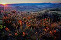
The ecology of the Sierra Nevada, located in the U.S. states of California and Nevada, is diverse and complex: the plants and animals are a significant part of the scenic beauty of the mountain range. The combination of climate, topography, moisture, and soils influences the distribution of ecological communities across an elevation gradient from 500 to 14,500 feet. Biotic zones range from scrub and chaparral communities at lower elevations, to subalpine forests and alpine meadows at the higher elevations. Particular ecoregions that follow elevation contours are often described as a series of belts that follow the length of the Sierra Nevada. There are many hiking trails, paved and unpaved roads, and vast public lands in the Sierra Nevada for exploring the many different biomes and ecosystems.

Junipero Serra Peak is the highest mountain in the Santa Lucia range of central California. It is also the highest peak in Monterey County, and is located within the boundaries of Los Padres National Forest. It is named after Saint Junípero Serra, the Spanish Franciscan priest who founded the California Missions in the 18th century. There is a fire lookout, with a tower and building, near the peak that was constructed around 1935. An unauthorized skiing operation on the summit was reported sometime before 1970. Good astronomical observing conditions were an early attraction to the peak. Astronomers scratched a trail to the summit in January 1880 to observe a total eclipse of the sun. Observations from the peak were also made on the transit of Venus in 1882.

Inyo National Forest is a United States National Forest covering parts of the eastern Sierra Nevada of California and the White Mountains of California and Nevada. The forest hosts several superlatives, including Mount Whitney, the highest point in the contiguous United States; Boundary Peak, highest point in Nevada; and the Ancient Bristlecone Pine Forest that protects the oldest trees in the world. The forest, encompassing much of Owens Valley, was established by Theodore Roosevelt as a way of sectioning off land to accommodate the Los Angeles Aqueduct project in 1907, making the Inyo National Forest one of the least wooded forests in the United States' system.

Tahoe National Forest is a United States National Forest located in California, northwest of Lake Tahoe. It includes the 8,587-foot (2,617 m) peak of Sierra Buttes, near Sierra City, which has views of Mount Lassen and Mount Shasta. It is located in parts of six counties: Sierra, Placer, Nevada, Yuba, Plumas and El Dorado. The forest has a total area of 871,495 acres. Its headquarters is in Nevada City, California. There are local ranger district offices in Camptonville, Foresthill, Sierraville and Truckee.

Eldorado National Forest is a U.S. National Forest located in the central Sierra Nevada mountain range, in eastern California.

The Currant Mountain Wilderness is a 47,357-acre (19,165 ha) wilderness area centered on Currant Mountain in the White Pine Range of Nye County and White Pine County, in the eastern section of the state of Nevada in the western United States.
The White Pine Range Wilderness is a 40,013-acre (16,193 ha) wilderness area in southwestern White Pine County, in the U.S. state of Nevada.
The Bald Mountain Wilderness is a 22,366-acre (9,051 ha) wilderness area in White Pine County, in the U.S. state of Nevada. The Wilderness lies within the Humboldt-Toiyabe National Forest and is administered by the U.S. Forest Service.

The Red Mountain Wilderness is a 20,490-acre (8,290 ha) wilderness area in southwestern White Pine County and northeastern Nye County, within the White Pine Range in the U.S. state of Nevada. The Wilderness lies within the Humboldt-Toiyabe National Forest, administered by the U.S. Forest Service.

The Mokelumne Wilderness is a 105,165-acre federally designated wilderness area located 70 miles (110 km) east of Sacramento, California. It is within the boundaries of three national forests: Stanislaus, Eldorado and Toiyabe. First protected under the Wilderness Act of 1964, the Mokelumne's borders were expanded under the California Wilderness Act of 1984 with the addition of 55,000 acres. The wilderness takes its name from the Mokelumne River, which was named after a Mi-wok Indian village located on the riverbank in California's Central Valley.
The Great Basin montane forests is an ecoregion of the Temperate coniferous forests biome, as designated by the World Wildlife Fund (WWF).