
The Black Rock Desert is a semi-arid region of lava beds and playa, or alkali flats, situated in the Black Rock Desert–High Rock Canyon Emigrant Trails National Conservation Area, a silt playa 100 miles (160 km) north of Reno, Nevada that encompasses more than 300,000 acres (120,000 ha) of land and contains more than 120 miles (200 km) of historic trails. It is in the northern Nevada section of the Great Basin with a lakebed that is a dry remnant of Pleistocene Lake Lahontan.

Gerlach, Nevada is a census-designated place (CDP) in Washoe County, Nevada, United States. The population was 107 at the 2018 American Community Survey. It is part of the Reno–Sparks Metropolitan Statistical Area. Prior to 2010, Gerlach was part of the Gerlach–Empire census-designated place. The town of Empire is now a separate CDP. The next nearest town, Nixon, is 60 miles (100 km) to the south on a reservation owned by the Pyramid Lake Paiute Tribe. The Fly Geyser is located near Gerlach.
State Route 28 (SR 28) is a 16.3-mile (26.2 km) state highway in Douglas County, Carson City, and Washoe County in western Nevada, United States, that runs along the northeastern shore of Lake Tahoe. SR 28 connects U.S. Route 50 (US 50) in Douglas County with California State Route 28 at Crystal Bay. SR 28 has been part of the Nevada scenic byway system since June 1994 and the National Scenic Byway system since September 1996.

State Route 140 is a two-lane state highway in Humboldt County, Nevada. It serves a sparsely populated section of the state, connecting northwestern Nevada to southern Oregon. Most of the highway was originally part of State Route 8A, and was later improved through an effort to provide an all-weather highway linking northern Nevada to the Pacific Northwest.
Interstate 80 (I-80) traverses the northern portion of the U.S. state of Nevada. The freeway serves the Reno–Sparks metropolitan area and passes through the towns of Fernley, Lovelock, Winnemucca, Battle Mountain, Carlin, Elko, Wells and West Wendover on its way through the state.
State Route 341 is a state highway in western Nevada connecting US 50 near Dayton to Reno via Virginia City. Commonly known as the Virginia City Highway, or Geiger Grade north of Virginia City, the route has origins dating back to the 1860s.
State Route 667 is a state highway in the Reno-Sparks metropolitan area of Washoe County, Nevada. It follows a portion of Kietzke Lane, a major north–south arterial in the area.

State Route 854 is a state highway in Pershing County, Nevada serving the vicinity of Lovelock. The route comprised a portion of former State Route 48.

In the U.S. state of Nevada, U.S. Route 50 Alternate is an east–west alternate route of U.S. Route 50. The highway splits from US 50 in Silver Springs, heading north to Fernley and then southeast to rejoin US 50 west of Fallon. Over the years, the route has held several numerical highway designations.
Former State Route 49, also known as Jungo Road, is an unimproved road from County Route 447 near Gerlach east to Winnemucca via the ghost towns of Sulphur and Jungo. It crosses the Kamma Mountains northeast of Sulphur. Most of the route runs parallel to the Feather River Route, a rail line originally built by the Western Pacific Railroad. In addition to an access for the ghost towns, the road also is an access for the Black Rock Desert from the East.

State Route 34 is a decommissioned state highway in Nevada from prior to the state's highway restructuring in 1978. Today a portion of former SR 34 is maintained by the Washoe County as a county highway with the not well known designation CR 34. A portion of State Route 447 was formerly SR 34, though the former SR 34 road bed is still used from Gerlach, Nevada to near Vya, Nevada.

State Route 431, commonly known as the Mount Rose Highway, is a 24.413-mile-long (39.289 km) two-lane highway in Washoe County, Nevada, that connects Incline Village at Lake Tahoe with Reno. The highway, a Nevada Scenic Byway, takes its name from Mount Rose, which lies just off the highway. Prior to 1976, the highway existed as State Route 27.
U.S. Route 395 (US 395) is a United States Numbered Highway, stretching from Hesperia, California to the Canadian border in Laurier, Washington. The California portion of US 395 is a 557-mile (896 km) route which traverses from Interstate 15 (I-15) in Hesperia, north to the Oregon state line in Modoc County near Goose Lake. The route clips into Nevada, serving the cities Carson City and Reno, before returning to California.

U.S. Route 395 (US 395) is an 85-mile-long (137 km) United States Numbered Highway near Lake Tahoe in the state of Nevada. It traverses the state after entering from California in Topaz Lake and crosses back into California near Hallelujah Junction. US 395 serves the cities of Gardnerville, Minden, Carson City and Reno. All of US 395 north of Carson City is a freeway and is built up to Interstate Highway standards. Part of the freeway section is also designated as Interstate 580 (I-580).
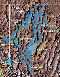
The Lahontan Valley is a basin in Churchill County, Nevada, United States. The valley is a landform of the central portion of the prehistoric Lake Lahontan's lakebed of 20,000-9,000 years ago. The valley and the adjacent Carson Sink represent a small portion of the lake bed. Humboldt Lake is to the valley's northeast. Pyramid Lake is west. Walker Lake is to the south.

State Route 446 is a 13.156-mile-long (21.173 km) state highway serving Washoe County, Nevada. The route runs from SR 445 to SR 447 at the town of Nixon.
State Route 427 is a 4.7-mile-long (7.6 km) state highway in the U.S. state of Nevada. It connects the community of Wadsworth in eastern Washoe County to the city of Fernley in western Lyon County. SR 427 comprises the former routing of U.S. Route 40 through the towns it serves. SR 427 also provides an eastern link to Pyramid Lake via a junction with State Route 447 in Wadsworth.
State Route 659 is a state highway in Washoe County, Nevada. The route follows McCarran Boulevard, an arterial ring road serving the cities of Reno and Sparks. The route provides access to many businesses and residential areas in the Truckee Meadows.


