Truckee River

Last updated • 7 min readFrom Wikipedia, The Free Encyclopedia
Truckee River
Salmon Trout River [1]
Truckee river.JPG
The Truckee River just east of Truckee, California
Truckeerivermap.png
Map of the Pyramid Lake drainage basin
EtymologyNamed after the Paiute chief Truckee
Native name
Location
Country United States
State California, Nevada
Physical characteristics
Source Lake Tahoe
  location Sierra Nevada, California
  coordinates 39°10′3″N120°8′39″W / 39.16750°N 120.14417°W / 39.16750; -120.14417 [2]
  elevation6,233 ft (1,900 m) [3]
Mouth Pyramid Lake
  location
Nevada
  coordinates
39°51′27″N119°26′53″W / 39.85750°N 119.44806°W / 39.85750; -119.44806 Coordinates: 39°51′27″N119°26′53″W / 39.85750°N 119.44806°W / 39.85750; -119.44806 [2]
  elevation
3,793 ft (1,156 m) [2]
Length121 mi (195 km) [3]
Basin size3,060 sq mi (7,900 km2) [4]
Discharge 
  location USGS gage 10350000, Truckee River at Vista, NV [5]
  average804 cu ft/s (22.8 m3/s) [5]
  minimum7 cu ft/s (0.20 m3/s)
  maximum17,400 cu ft/s (490 m3/s)

The Truckee River is a river in the U.S. states of California and Nevada. The river flows northeasterly and is 121 miles (195 km) long. [3] [6] The Truckee is the sole outlet of Lake Tahoe and drains part of the high Sierra Nevada, emptying into Pyramid Lake in the Great Basin. Its waters are an important source of irrigation along its valley and adjacent valleys.

Contents

Naming of the river

A Northern Paiute word for the Truckee is Kuyuinahukwa. Kuyui- refers to the Cui-ui, a species of fish endemic to Pyramid Lake which is central to the lives of the Northern Paiute band called the Kuyui Dükadü (cui-ui-fish-eaters). [7]

In the Washo language, different parts of the river have different names. Two names, ‘Át’abi wá’t’a and Á’waku wá’t’a translate to "trout stream." [8] The latter name refers to the river at and around Pyramid Lake. [9] At the outlet at Lake Tahoe, there are multiple names as well. Dawbayódok is said to refer to the area when one is situated "on the down side" of the outlet, while Dawbayóduwé is used when one is "on the up side." Debeyúmewe, translated as "coming out," is less specific. [10]

When John C. Frémont and Kit Carson ascended the Truckee River on January 16, 1844, they called it the Salmon Trout River, [1] after the huge Lahontan cutthroat trout (Oncorhynchus clarki henshawi) that ran up the river from Pyramid Lake to spawn. However, the river was ultimately named after a Paiute chief known as Truckee, who in 1844 guided an emigrant party from the headwaters of the Humboldt River to California via the Truckee River, Donner Lake, and Donner Pass. Appreciative of their Native American guide's services, the party named the river after him. [11] The chief's real name might not have been Truckee, but perhaps Tru-ki-zo, which could have become distorted as "Truckee". There are numerous other theories about Chief Truckee and his name. [12]

Course and watershed

The Truckee River at Verdi, Nevada, when the Central Pacific Railroad reached the site in 1868 Truckee River at Verdi, east of the Sierra Nevada mountains, Nevada, Central Pacific R.R, by Thomas Houseworth & Co..jpg
The Truckee River at Verdi, Nevada, when the Central Pacific Railroad reached the site in 1868
The Truckee River in Truckee, California, with Donner Creek flowing in from the right Trukee River Donner Creek confluence.jpg
The Truckee River in Truckee, California, with Donner Creek flowing in from the right

The Truckee River's source is the outlet of Lake Tahoe, at the dam on the northwest side of the lake near Tahoe City, California. It flows generally northeast through the mountains to Truckee, California, then turns sharply to the east and flows into Nevada, through Reno and Sparks and along the northern end of the Carson Range. At Fernley it turns north, flowing along the east side of the Pah Rah Range. It empties into the southern end of Pyramid Lake, a remnant of prehistoric Lake Lahontan, in northern Washoe County in the Pyramid Lake Indian Reservation. [13]

The Truckee River's endorheic drainage basin is about 3,060 square miles (7,900 km2), of which about 2,300 square miles (6,000 km2) are in Nevada. [4] The Middle Watershed is regarded as the 15 miles (24 km) of river and its tributaries from Tahoe City in Placer County, through the Town of Truckee in Nevada County, to the state line between Sierra and Washoe counties. The major tributaries to the Truckee River in California from the Lake Tahoe outlet and heading downstream include: Bear Creek, Squaw Creek, Cabin Creek, Pole Creek, Donner Creek, Trout Creek, Martis Creek, Prosser Creek, the Little Truckee River, Gray Creek, and Bronco Creek. Major lakes and reservoirs in the California part of the watershed include Lake Tahoe, Donner Lake, Independence Lake (California), Webber Lake, Boca Reservoir, Stampede Reservoir, Prosser Creek Reservoir, and Martis Creek Reservoir. [14] In the Lower Watershed, Steamboat Creek, which drains Washoe Lake, is the major tributary to the Truckee River.

River modifications

Aerial view from the south of the Truckee River where it drains to Pyramid Lake Pyramid Lake and Truckee River.jpg
Aerial view from the south of the Truckee River where it drains to Pyramid Lake

Like many other rivers in the western United States, the Truckee's flow is highly regulated, with most river flow fully allocated through a system of water rights, set in 2015 by the Truckee River Operating Agreement. This system over-allocates available water during low flow periods. Disputes occur among those asserting rights to the water. In the early 20th century, the Newlands Reclamation Act instituted a diversion that removed river flows from the Truckee River watershed and transferred them to the Carson River watershed. [15] Currently the Truckee–Carson Irrigation District supervises the diversion of approximately one-third of the river flow at the Derby Dam to the Lahontan Valley to irrigate alfalfa and pastures. Truckee River water is also supplied to the resort communities surrounding Lake Tahoe, the greater metropolitan area of Reno and Sparks, and the Pyramid Lake Paiute Indian Reservation. The U.S. Fish and Wildlife Service uses some of the water to induce spawning of the endangered fish cui-ui and to provide drought relief.

Ecology

Beavers were re-introduced to the Truckee River watershed and Tahoe Basin by the California Department of Fish and Game (CDFG) and the U. S. Forest Service between 1934 and 1949 in order to prevent stream degradation and to promote wetland restoration. That beaver were once native to the area is supported by the fact that the Washo have a word for beaver, c'imhélhel [16] [17] and the northern Paiute of Walker Lake, Honey Lake and Pyramid Lake have a word for beaver su-i'-tu-ti-kut'-teh. [18] When Stephen Powers visited the northern Paiute to collect Indian materials for the Smithsonian Institution in preparation for the Centennial Exhibition of 1876, he reported that the northern Paiute wrapped their hair in strips of beaver fur, made medicine from parts of beaver and that their creation legend included beaver. [18] In addition, fur trapper Stephen Hall Meek "set his traps on the Truckee River in 1833", which strongly suggests that he saw a beaver or beaver sign. [19] Supporting this line of evidence, Tappe records in 1941 an eyewitness who said beaver were plentiful on the eastern slope of the Sierra Nevada on the upper part of the Carson River and its tributaries in Alpine County until 1892 when they fell victim to heavy trapping. [20] James "Grizzly" Adams' also reports trapping beaver in the lower Carson River around 1860, "In the evening we caught a fine lot of salmon-trout (Cutthroat trout), using grasshoppers for bait, and in the night killed half a dozen beavers, which were very tame." [21] Recent novel physical evidence of beaver's historic presence in the Sierra Nevada was the discovery of beaver dams dating to the 1850s in Red Clover Creek in the Feather River watershed. [22] The presence of beaver dams has been shown to either increase the number of fish, their size, or both, in a study of brook, rainbow and brown trout in nearby Sagehen Creek, which flows into the Little Truckee River at an altitude of 5,800 feet (1,800 m) and is a stream typical of the eastern slope of the northern Sierra Nevada. [23] Not only have aspen and cottonwood survived ongoing beaver colonization but a recent study of ten Tahoe streams utilizing aerial multispectral videography, including Trout Creek and Cold Creek, has shown that deciduous, thick and thin herbaceous vegetation has increased near beaver dams, whereas coniferous trees are decreased. [24] Benefits of beaver dams include removal of sediment and excessive pollutants travelling downstream, which improves water clarity, which was shown to worsen when beaver dams were recently removed in nearby Taylor Creek and Ward Creek. [25] Flooding from beaver dams is relatively inexpensively controlled with flow devices.

Recreation

Rafting and tubing for recreation on the Truckee River in Reno Nevada USA on the 4th of July 2018 Truckee River Reno Nevada 4th of July 2018.jpg
Rafting and tubing for recreation on the Truckee River in Reno Nevada USA on the 4th of July 2018
The headwaters of the Truckee River at Lake Tahoe Dam Lake Tahoe Dam 1.jpg
The headwaters of the Truckee River at Lake Tahoe Dam
The Truckee River near Truckee, California. Truckee River, 25 November 2006.jpg
The Truckee River near Truckee, California.

The river is heavily used for recreation, including whitewater rafting and fly fishing. A common rafting run is the River Ranch Run. Starting from the outlet gates at Lake Tahoe stretching about 3 miles (4.8 km), the run ends at the River Ranch Restaurant. These rapids are almost all class 1 and class 2. In downtown Reno the river has been sculpted into a half-mile Class 2/3 whitewater park, and is used mainly for kayaking. [26]

The Truckee River is western Nevada's largest river. It supports a large sport fishing population each year. Kim Tisdale of the Nevada Department of Wildlife (NDOW), is the state's Western Regions Fishery Supervisor; she commented that NDOW's goal is for a catch rate of one to two fish per hour in the Truckee. To accomplish this, NDOW stocks a total of 105,000 trout per year. 70,000 of those are native Lahontan cutthroat trout (Oncorhynchus clarki henshawi) and the rest are non-native Rainbow trout (Oncorhynchus mykiss). [27] The Truckee also boasts a healthy, self-sustaining non-native Brown trout (Salmo trutta) population. [27]

Hydrology and water quality

Because of the endangered species present and because the Lake Tahoe Basin comprises the headwaters of the Truckee River, the river has been the focus of several water quality investigations, the most detailed starting in the mid-1980s. Under the direction of the U.S. Environmental Protection Agency, a comprehensive dynamic hydrology transport model was developed by Earth Metrics Inc. [28] The model's name was subsequently changed to DSSAM, and it was applied to analyze land use, and wastewater management decisions throughout the Truckee River Basin of 3,120 square miles (8,081 km2) and to provide guidance in other U.S. river basins. [29] Analytes addressed included nitrogen, reactive phosphate, dissolved oxygen, total dissolved solids and nine other parameters. Based on the use of the model, some decisions have been influenced to enhance riverine quality and aid the viability of associated biota. Impacts upon the receiving waters of Pyramid Lake were also analyzed.

See also

Related Research Articles

<span class="mw-page-title-main">Lake Tahoe</span> Lake in California and Nevada, United States

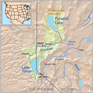
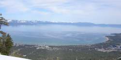
Lake Tahoe is a freshwater lake in the Sierra Nevada of the United States. Lying at 6,225 ft (1,897 m), it straddles the state line between California and Nevada, west of Carson City. Lake Tahoe is the largest alpine lake in North America, and at 122,160,280 acre⋅ft (150.7 km3) it trails only the five Great Lakes as the largest by volume in the United States. Its depth is 1,645 ft (501 m), making it the second deepest in the United States after Crater Lake in Oregon.

<span class="mw-page-title-main">Pyramid Lake (Nevada)</span> Lake in Nevada, United States

Pyramid Lake is the geographic sink of the basin of the Truckee River, 40 mi (64 km) northeast of Reno, Nevada, United States.

<span class="mw-page-title-main">Derby Dam</span> United States historic place

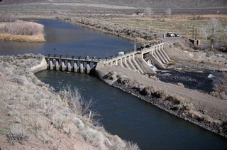
Derby Dam is a diversion dam built from 1903 to 1905 on the Truckee River, located about 20 miles (32 km) east of Reno in Storey and Washoe counties in Nevada, United States. It diverts water into the Truckee Canal that would otherwise enter Pyramid Lake. The canal feeds Lake Lahontan reservoir in the Carson River watershed, where it is used for irrigation.

<span class="mw-page-title-main">Carson River</span> River in Nevada, United States

The Carson River is a northwestern Nevada river that empties into the Carson Sink, an endorheic basin. The main stem of the river is 131 miles (211 km) long although the addition of the East Fork makes the total length 205 miles (330 km), traversing five counties: Alpine County in California and Douglas, Storey, Lyon, and Churchill Counties in Nevada, as well as the Consolidated Municipality of Carson City, Nevada. The river is named for Kit Carson, who guided John C. Frémont's expedition westward up the Carson Valley and across Carson Pass in winter, 1844. The river made the National Priorities List (NPL) on October 30, 1990 as the Carson River Mercury Superfund site (CRMS) due to investigations that showed trace amounts of mercury in the wildlife and watershed sediments.

<span class="mw-page-title-main">Washoe people</span> Indigenous people of North America

The Washoe or Wašišiw are a Great Basin tribe of Native Americans, living near Lake Tahoe at the border between California and Nevada. The name "Washoe" or "Washo" is derived from the autonym Waashiw in the Washo language or from Wašišiw (waší:šiw), the plural form of wašiw.

<span class="mw-page-title-main">Walker River</span> River in Nevada, United States

The Walker River is a river in west-central Nevada in the United States, approximately 62 miles (100 km) long. Fed principally by snowmelt from the Sierra Nevada of California, it drains an arid portion of the Great Basin southeast of Reno and flows into the endorheic basin of Walker Lake. The river is an important source of water for irrigation in its course through Nevada; water diversions have reduced its flow such that the level of Walker Lake has fallen 160 feet (49 m) between 1882 and 2010. The river was named for explorer Joseph Reddeford Walker, a mountain man and experienced scout who is known for establishing a segment of the California Trail.

<span class="mw-page-title-main">Truckee Meadows</span>

The Truckee Meadows is a valley in Northern Nevada, named for the Truckee River, which collects and drains all water in the valley. Truckee Meadows is also colloquially used as a name for the Reno–Tahoe-Fernley CSA area, even though the metro area includes areas outside this valley. The name for the valley in the Washo language is Welganuk.

<span class="mw-page-title-main">Lahontan cutthroat trout</span> Subspecies of fish

Lahontan cutthroat trout is the largest subspecies of cutthroat trout, and the state fish of Nevada. It is one of three subspecies of cutthroat trout that are listed as federally threatened.

<span class="mw-page-title-main">Washoe Lake</span> Body of water

Washoe Lake is a lake located near Carson City in the Washoe Valley of Washoe County, Nevada. It is a very shallow lake with a surface area that can vary greatly from year to year. Washoe Lake State Park sits on the lake's southeastern shore.

<span class="mw-page-title-main">DSSAM Model</span> Water quality computer simulation

The DSSAM Model is a computer simulation developed for the Truckee River to analyze water quality impacts from land use and wastewater management decisions in the Truckee River Basin. This area includes the cities of Reno and Sparks, Nevada as well as the Lake Tahoe Basin. The model is historically and alternatively called the Earth Metrics Truckee River Model. Since original development in 1984-1986 under contract to the U.S. Environmental Protection Agency (EPA), the model has been refined and successive versions have been dubbed DSSAM II and DSSAM III. This hydrology transport model is based upon a pollutant loading metric called Total maximum daily load (TMDL). The success of this flagship model contributed to the Agency's broadened commitment to the use of the underlying TMDL protocol in its national policy for management of most river systems in the United States.

<span class="mw-page-title-main">Upper Truckee River</span> River in California, United States

The Upper Truckee River is a stream that flows northward from the western slope of Red Lake Peak in Alpine County, California to Lake Tahoe via the Truckee Marsh in South Lake Tahoe, California. The river flows northeasterly and is 23 miles (37 km) long. It is Lake Tahoe's largest tributary.

<span class="mw-page-title-main">Western Nevada</span> Place in Nevada, United States

Western Nevada (WNV) is a region and the northwestern portion of the U.S. state of Nevada that includes Reno, Carson City, Carson Valley and Virginia City. Lyon County and Churchill County are sometimes also referred to as part of Western Nevada.

<span class="mw-page-title-main">Beaver in the Sierra Nevada</span> Wildlife indigenous to California mountains

The North American beaver had a historic range that overlapped the Sierra Nevada in California. Before the European colonization of the Americas, beaver were distributed from the arctic tundra to the deserts of northern Mexico. The California Golden beaver subspecies was prevalent in the Sacramento and San Joaquin River watersheds, including their tributaries in the Sierra Nevada. Recent evidence indicates that beaver were native to the High Sierra until their extirpation in the nineteenth century.

<span class="mw-page-title-main">Martis Creek</span> River in California, United States

Martis Creek is a northward-flowing stream originating on Sawtooth Ridge, west of the peak of Mount Pluto in Placer County, California, United States. After crossing into Nevada County, California, it is tributary to the Truckee River on the eastern side of Truckee.

<span class="mw-page-title-main">Trout Creek (Lake Tahoe)</span> River in California, United States

Trout Creek is a northward-flowing stream originating on the west side of Armstrong Pass on the Carson Range in El Dorado County, California, United States.

<span class="mw-page-title-main">Trout Creek (Truckee River tributary)</span> River in California, United States

Trout Creek is a small tributary of the Truckee River draining about 5.1 square miles (13 km2) along the eastern crest of the Sierra Nevada. It originates east of Donner Ridge and north of Donner Lake in the Tahoe–Donner Golf Course and flows through the town of Truckee, California, to its confluence with the Truckee River in Nevada County, California, just west of Highway 267.

<span class="mw-page-title-main">Lake Tahoe Dam</span> Dam in California, United States

Lake Tahoe Dam is a concrete gravity dam on the Truckee River, at the outlet of Lake Tahoe in Placer County, California.

<span class="mw-page-title-main">Taylor Creek (Lake Tahoe)</span> River in California, United States

Taylor Creek is a 2.2-mile-long (3.5 km) northward-flowing stream originating in the Fallen Leaf Lake and culminating at Baldwin Beach at Lake Tahoe, about 1 mile (1.6 km) west of Camp Richardson in El Dorado County, California.

<span class="mw-page-title-main">Blackwood Creek (California)</span> River in California, United States

Blackwood Creek, is a 8-mile-long (13 km) eastward-flowing stream originating on the southwest flank of Ellis Peak in the Sierra Nevada. The creek flows into Lake Tahoe 4.2 miles (6.8 km) south of Tahoe City, California, between the unincorporated communities of Idlewild and Tahoe Pines in Placer County, California, United States.

North Canyon Creek is a 6.8-mile-long (10.9 km) southwestward-flowing stream originating on Snow Valley Peak in the Carson Range of the Sierra Nevada. Most of the stream is in Carson City, Nevada, United States. It is a tributary stream of Lake Tahoe culminating at Glenbrook in Douglas County on Tahoe's Nevada shore.

References

  1. 1 2 John Charles Fremont (1847). Narrative of the exploring expedition to the Rocky mountains: in the year 1842, and to Oregon and north California in the years 1843–44. Hall & Dickson. p.  309 . Retrieved 2010-12-13. salmon trout river.
  2. 1 2 3 U.S. Geological Survey Geographic Names Information System: Truckee River
  3. 1 2 3 U.S. Geological Survey. National Hydrography Dataset high-resolution flowline data. The National Map, accessed October 20, 2012
  4. 1 2 Rigby, Jim G. (1998). The 1997 New Year's Floods in Western Nevada. Nevada Bureau of Mines and Geology. p. 5. ISBN   978-1-888035-03-2.
  5. 1 2 "Water resources data for the United States, Water Year 2009; gage 10350000, Truckee River at Vista, NV" (PDF). USGS . Retrieved 4 August 2010.
  6. Justin Bartlett; John J. Warwick (August 2009). "Assessing the Impacts of Nutrient Load Uncertainties on Predicted Truckee River Water Quality". Journal of Environmental Engineering. 135 (8): 636–644. doi:10.1061/(ASCE)0733-9372(2009)135:8(636).
  7. Ginny Bengston (2002). Northern Paiute and Western Shoshone Land Use in Northern Nevada: A Class I Ethnographic/Ethnohistoric Overview (PDF). SWCA Environmental Consultants. pp. 6, 50. Retrieved 2022-12-30.
  8. Natalie E. Davenport (2019). Naming, Remembering, and Experiencing We’ lmelt’ iʔ [northern Washoe] Cultural Spaces in Wa she shu It Deh [Washoe Land] (PDF). ScholarWorks, University of Nevada, Reno. p. 235. Retrieved 2022-12-31. Ahwacoo watah, means “trout stream” (Lindström 1992a, 196 from Freed 1966; Nevers 1976, 4; Dixon, Schablitsky, and Novak 2011, 257). ... ‘Át’abi wá’t’a (d’Azevedo 1956, 57/#134) was also translated as “trout stream”(Lindström 1992a, 196; from Freed 1966).
  9. Natalie E. Davenport (2019). Naming, Remembering, and Experiencing We’ lmelt’ iʔ [northern Washoe] Cultural Spaces in Wa she shu It Deh [Washoe Land] (PDF). ScholarWorks, University of Nevada, Reno. p. 304. Retrieved 2022-12-31. Freed (1966) and Nevers (1976) provided the Washoe name, Ahwacoo watah,“trout stream,” for the segment of the Truckee River near Pyramid Lake
  10. Natalie E. Davenport (2019). Naming, Remembering, and Experiencing We’ lmelt’ iʔ [northern Washoe] Cultural Spaces in Wa she shu It Deh [Washoe Land] (PDF). ScholarWorks, University of Nevada, Reno. p. 209. Retrieved 2022-12-31.
  11. Truckee River Chronology Archived 2010-05-27 at the Wayback Machine , State of Nevada Division of Water Resources
  12. Chief Truckee Archived 2012-10-28 at the Wayback Machine , Truckee–Donner Historical Society
  13. USGS topographic maps
  14. David McGraw; Alan McKay; Guohong Duan; Thomas Bullard; Tim Minor; Jason Kuchnicki (July 2001). Water Quality Assessment and Modeling of the California Portion of the Truckee River Basin McGraw 2001 (PDF) (Report). Lahontan Regional Water Quality Control Board. Retrieved 2012-10-21.
  15. "Welcome to the TROA – Truckee River Operating Agreement". www.troa.net. Retrieved 13 September 2017.
  16. "The Washo Project Online Dictionary" . Retrieved 2012-07-07.
  17. A. L. Kroeber (1919). "30". Handbook of Indians of California. Retrieved 2010-08-19.
  18. 1 2 Don D. Fowler; Catherine S. Fowler; Stephen Powers (Summer–Autumn 1970). "Stephen Powers' "The Life and Culture of the Washo and Paiutes"". Ethnohistory. 17 (3/4): 117–149. doi:10.2307/481206. JSTOR   481206.
  19. Jesse D. Mason (1881). History of Amador County. Oakland, California: Thompson & West. Retrieved 2010-12-24.
  20. Tappe, Donald T. (1942). "The Status of Beavers in California" (PDF). Game Bulletin No. 3. California Department of Fish & Game: 14. Retrieved 2010-12-30.
  21. Theodore Henry Hittell (1861). The adventures of James Capen Adams: mountaineer and grizzly bear hunter, of California. Crosby, Nichols, Lee and company. p.  250 . Retrieved 2011-12-24. salmon-trout.
  22. James, C. D.; Lanman, R. B. (Spring 2012). "Novel physical evidence that beaver historically were native to the Sierra Nevada". California Fish and Game. 98 (2): 129–132.
  23. Gard R (1961). "Effects of beaver on trout in Sagehen Creek, California". Journal of Wildlife Management. 25 (3): 221–242. doi:10.2307/3797848. JSTOR   3797848.
  24. Michael Benson Ayers (October 1997). Aerial Multispectral Videography for Vegetation Mapping and Assessment of Beaver Distribution within Selected Riparian Areas of the Lake Tahoe Basin (Thesis). University of Nevada at Reno. p. 71. Retrieved 2010-08-26.
  25. Sarah Muskopf (October 2007). The Effect of Beaver (Castor canadensis) Dam Removal on Total Phosphorus Concentration in Taylor Creek and Wetland, South Lake Tahoe, California (Thesis). Humboldt State University, Natural Resources. hdl:2148/264.
  26. "Whitewater Park". City of Reno. Retrieved 2020-10-05.
  27. 1 2 Tisdale, Kim. Telephone Interview. 29 June 2012
  28. C. Michael Hogan. Marc Papineau et al., Development of a dynamic water quality simulation model for the Truckee River, Earth Metrics Inc., Environmental Protection Agency Technology Series, Washington D.C. (1987)
  29. USEPA. 1991. Guidance for water quality-based decisions: The TMDL process. EPA 440/4-91-001. U.S. Environmental Protection Agency, Office of Water, Washington, DC.