Paradise is an incorporated town in Butte County, California, United States, in the Sierra Nevada foothills above the northeastern Sacramento Valley.[2] As of the 2020 census, the town population was 4,764, a decline of over 80% from the 26,218 residents recorded in the 2010 census.[7]
On November 8, 2018, a major wildfire, the Camp Fire, destroyed most of Paradise and much of the adjacent communities of Magalia, Butte Creek Canyon, and Concow.[8][9] In November 2023, it was reported that there were a little over 9,000 residents living in Paradise. Over 2,500 new structures have also been built, with more construction ongoing.[10]
History
The first post office was established at Paradise in 1877. It closed for a time in 1911, but was re-established later that year, when the post office at Orloff was closed.[11] Paradise incorporated in 1979.[11] For many years, the Butte County Railroad operated trains along the ridge, serving mines and sawmills.
Naming
According to GNIS, the community has been known in the past by four different names or spellings: Leonards Mill, Poverty Ridge, Pair-O-Dice, and Paradice.[2]
A legend persists that the town was named because it was the home of the Pair o' Dice Saloon, an idea supported by a 1900 railroad map referring to the town as Paradice. However, no documentation has been found to prove the establishment existed, nor an explanation of the spelling of the town's name on the map.[12]
Gene Sylva, a former mayor of the nearby town of Oroville, has stated that the saloon story is false, and that the true etymology of the town's name can be traced to his great-great-grandfather, William Pierce Leonard, who named the town on a summer day in 1864, after a hot and dusty ride from the Sacramento Valley; arriving at his sawmill while the staff were on break, Leonard "took a deep breath of the cool, clean air, and exclaimed, 'boys, this is paradise.'"[12] According to Snopes, Sylva's explanation may be "pleasingly inventive historical fiction", and it is more likely that the town was named for it being a pleasant place to live.[12]
In June 2008, a wildfire, named the "Humboldt Fire" for its point of origin, swept over 22,800 acres (9,200ha) of land between Chico and Paradise. As many as 9,300 people were forced to evacuate southwestern Paradise until the fire could be brought under control.[13]
A month later, a fire burned on the northern side of Paradise in the canyon where the Feather River is located. Again, thousands were evacuated from their homes, but the fire failed to cross the river.[14] It was part of a larger complex of fires called the Butte Lightning Complex or BTU Complex,[15] which also included the Belden and Pit fires.[16] (This was a different fire from the 2018 fire of the same name.)
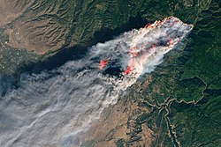
Satellite image showing the fire at 10:45 a.m. on November 8, 2018
On November 8, 2018, a wildfire named the "Camp Fire" was reported at 6:33a.m. PST, close to Camp Creek Road near Pulga.[17] Shortly after the fire erupted, the Butte County Sheriff's Office ordered the evacuation of the eastern quarter of Paradise, and the remaining portions one hour later.[18] However, many residents never received an evacuation warning, while others chose not to leave because the warnings did not convey the urgency of the situation.[19] Other locations were also issued evacuation orders or warnings, and emergency shelters were established.[20]
On the same day, much of the town of Paradise and the communities of Concow and Magalia were destroyed by this fire.[21] Scott McLean, a Cal Fire Deputy Chief, said, "We're talking devastated... . The town center is completely on the ground. The south side as well as the north side has been hit very hard, as well."[22][23]
A total of 85[24] people died in the Camp Fire, tens of thousands were displaced, and 18,804 buildings were destroyed. Only 5% of buildings in the town remained without serious damage after the fire.[8][9] It was the deadliest and most destructive fire in California history.[25] Negligence on the part of Pacific Gas & Electric (PG&E) was found to be the cause of the fire.[26]
Camp Fire recovery
A burnt-down house in Paradise, eight months after the Camp Fire
The first two building permits were reissued for Paradise, after almost five months, on March 28, 2019. Local public policymakers aimed to promote rebuilding with higher standards for fire-resistant construction, upgraded infrastructure, and using the recommended 2009 redesigns for enhanced fire safety, which include expanded road capacity to increase evacuation capacity and to provide better access for emergency equipment.[27] Two weeks of rain in early March 2019 slowed removal of debris; it was prohibited to dump waterlogged waste in landfills. Some 1,000 truckloads of material were expected to be removed daily from properties in Paradise, Concow, and Magalia. Cleanup was anticipated to take a year, involving 11,000 properties.[28]
In 2010 the U.S. census reported a population of 26,800. After the Camp Fire, the population declined by more than 90%.[29] In January 2019, the state of California reported 4,600 residents, and a door-to-door count in April 2019 found 2,034.[30] In the ensuing years, however, more residents have slowly returned to the town. By November 2023, it was reported that there were a little over 9,000 residents living in Paradise. Over 2,500 new structures had also been built, with more construction ongoing.[10]
By 2024, the town had experienced a substantial influx of newcomers who had moved from the Bay Area and Southern California. Building codes had changed, so displaced residents could not rebuild under codes that had formerly allowed homes smaller than 750 square feet (70m2). Insurance costs had exploded, with annual premiums of $12,000 becoming commonplace.[31]
One year after the fires, the town united behind the Paradise High School football team, which achieved an undefeated season. One team member commented, "You look at the stands, the whole town of Paradise is here, so it's really our only event right now, so it means everything."[32] Paradise Mayor Jody Jones said, "The football team has come to represent all of us.”[33]Los Angeles Times columnist Bill Plaschke was inspired to write a book about the team and the town, Paradise Found: A High School Football Team's Rise from the Ashes (2021).[34]
Paradise Greenbelt Buffer Plan
After the 2018 Camp Fire caused near complete destruction of Paradise, the town and residents agreed on a Long-Term Community Recovery Plan with five main goals to make the town Safer, Welcoming, Stronger, Better, and Greener.[35] Paradise Recreation and Parks District (PRPD) and the Nature Conservancy teamed up to develop the idea of a Greenbeltdefensible buffer zone which would make the town a better fire-adapted community by preventing future wildfires from reaching the town center.[36] The greenbelt would be made up of managed parks and vegetation to allow firefighters to do controlled burns and create a barrier of land without fuel around the town (a firebreak) so future wildfires have no path inwards. This borderland would serve as a source of recreation and greenspace for the community. During the wildfire season, the buffer would protect the town.[36]
The Greenbelt hopes to accomplish a number of projects outlined in the plan, including improvements to parks and walking paths, a stronger fuel management plan, and better transportation access for residents and firefighters. The Nature Conservancy hired an independent nonprofit, the Conservation Biology Institute, to conduct a scientific report on the efficacy of such a barrier. According to their models, such greening of the eastern border of Paradise could reduce combustion risks in the town by as much as 64%.[36][37]
The most pressing challenges moving forward included obtaining rights to the mostly private land the Conservation Biology Institute identified as the most ideal location for a greenbelt, and funding the purchase of these properties.[36] With local fires worsening every year, PRDP is hoping residents will respond to their fire risk reduction models and sell their outskirt properties to the district. With the successful purchase of several properties so far, Dan Efseaff, district manager for PRDP, "hopes at least to create pockets or sections of that full vision."[36] If this becomes a successful model, the Nature Conservancy hopes to scale up lessons learned from Paradise and inspire other fire-threatened communities to implement their own buffers.[36]
2020 North Complex Fire
The North Complex Fire, also known as the "Bear Fire," to the east of Concow, and Pulga endangered Paradise and surrounding communities that had been affected by the 2018 Camp Fire, and evacuations were ordered. Remaining burn scars that had reduced combustible materials contained the westward progress of the 2020 fire, though almost 320,000 acres (130,000ha) were consumed before it was contained.[38]
Geography
Paradise is located 10 miles (16km)east of Chico and 85 miles (137km) north of Sacramento.
The town is spread out on a wide ridge between deep canyons formed by the west branch of the Feather River to the east and Butte Creek to the west. The Paradise area extends northward to include the unincorporated town of Magalia, as well as Stirling City, eleven miles (18km) north. Elevation of the area where the town is located is 1,778 feet (542m).[2] The town itself is approximately eight to ten miles (13 to 16km) east of the city of Chico, and ten miles (16km) north of the Oroville area.
According to the United States Census Bureau, the town has a total area of 18.3 square miles (47km2); over 99% of it is land.
Soils are mostly well-drained reddish-brown loam, gravelly in some cases and often grading to clay loam or clay with increasing depth. They have developed on volcanic material. Paradiso is by far the most common soil series in town.[39]
Climate
The area encompassing Paradise has a hot-summer Mediterranean climate (Csa) according to the Köppen climate classification system. This area is characterized by hot, dry summers and cool, rainy winters. Because of its elevation and up-sloping topography, which create orographic precipitation, Paradise has a much wetter climate than neighboring Chico, which is only about 10 miles distant but receives less than half the precipitation of Paradise. Paradise is also subject to occasional snowfall in winter, while snow is very rare in Chico.
The census reported that 98.9% of the population lived in households, 0.6% lived in non-institutionalized group quarters, and 0.4% were institutionalized.[42]
There were 2,172 households, out of which 21.8% included children under the age of 18, 45.8% were married-couple households, 8.3% were cohabiting couple households, 24.3% had a female householder with no partner present, and 21.5% had a male householder with no partner present. 31.1% of households were one person, and 17.8% were one person aged 65 or older. The average household size was 2.17.[42] There were 1,317 families (60.6% of all households).[43]
The age distribution was 14.4% under the age of 18, 4.8% aged 18 to 24, 18.6% aged 25 to 44, 30.8% aged 45 to 64, and 31.4% who were 65years of age or older. The median age was 55.6years. For every 100 females, there were 101.1 males.[42]
There were 2,493 housing units at an average density of 136.1 unitsper square mile (52.5 units/km2), of which 2,172 (87.1%) were occupied. Of these, 74.6% were owner-occupied, and 25.4% were occupied by renters.[42]
In 2023, the US Census Bureau estimated that the median household income was $67,042, and the per capita income was $36,444. About 18.4% of families and 18.0% of the population were below the poverty line.[44]
The Census reported that 25,810 people (98.4% of the population) lived in households, 139 (0.5%) lived in non-institutionalized group quarters, and 269 (1.0%) were institutionalized.
There were 11,893 households, out of which 2,574 (21.6%) had children under the age of 18 living in them, 5,227 (44.0%) were opposite-sex married couples living together, 1,308 (11.0%) had a female householder with no husband present, 511 (4.3%) had a male householder with no wife present. There were 742 (6.2%) unmarried opposite-sex partnerships, and 94 (0.8%) same-sex married couples or partnerships. 4,038 households (34.0%) were made up of individuals, and 2,126 (17.9%) had someone living alone who was 65 years of age or older. The average household size was 2.17. There were 7,046 families (59.2% of all households); the average family size was 2.73.
The age distribution was 4,501 people (17.2%) under the age of 18, 1,858 people (7.1%) aged 18 to 24, 4,822 people (18.4%) aged 25 to 44, 8,466 people (32.3%) aged 45 to 64, and 6,571 people (25.1%) who were 65 years of age or older. The median age was 50.2 years. For every 100 females, there were 90.5 males. For every 100 females age 18 and over, there were 88.5 males.
There were 12,981 housing units at an average density of 708.5 unitsper square mile (273.6 units/km2), of which 11,893 were occupied, of which 7,975 (67.1%) were owner-occupied, and 3,918 (32.9%) were occupied by renters. The homeowner vacancy rate was 2.8%; the rental vacancy rate was 5.9%. 17,381 people (66.3% of the population) lived in owner-occupied housing units and 8,429 people (32.1%) lived in rental housing units.
Government
The State of California Office of Statewide Health Planning and Development defined Feather River Hospital as a general acute care hospital (GACH) in Paradise with basic emergency care as of August 22, 2006.[citation needed] Since the 2018 Camp Fire, the hospital has been permanently closed, with no plans to reopen at this time.
The high school was virtually undamaged in the 2018 Camp Fire and reopened for the 2019–20 school year. Enrollment was expected to be about 600, but about 900 showed up for the first day of classes, with some displaced students traveling more than an hour each way.[47]
Ridgeview High School (continuation)
HomeTech Charter School (K–12)
Paradise Intermediate School (6–8)
Paradise Charter Middle School (6–8)
Children's Community Charter School (K–8)
Cedarwood Elementary School (K–5)
Paradise Elementary School (K–5)
Ponderosa Elementary School (K–6)
Pine Ridge School (K–8)
Honey Run Academy Elementary & Secondary (2 community day schools)
Pearson Center (school for 18-22-year-old significantly disabled special education students)
There are not many options for transportation within Paradise. The Paradise/Magalia area is served by the "B-Line" Butte County Transit.[48]Butte Community College also runs bus service for students.[49]
Paradise's link with Chico, Skyway Road (referred to locally as simply "Skyway"), begins in the Sacramento Valley, at Highway 99 in Chico, and runs up the ridge as a four-lane divided highway until it reaches Paradise. Through the town, it is a four-lane undivided highway, which becomes a two-lane road as it continues up the Sierra's ridge to Magalia and into numerous smaller communities to the north. Paradise is connected to Oroville via Highway 191, otherwise known as Clark Road upon entering the town.
The Paradise Memorial Trail is a paved pedestrian and bicycle path which runs through town on the path of the former railroad tracks leading up the ridge. However, aside from points along this path, the very hilly terrain of the town, coupled with the large spacing of commercial areas and large land area made Paradise difficult to navigate on foot or on a bicycle, in addition to the lack of sidewalks.[citation needed]
Paradise Skypark (FAA identifier: CA92) is an airport located parallel to State Route 191 and south of the town.
The PBS show This Old House season 41 included 4 episodes on rebuilding Paradise.[55]
The 2025 film The Lost Bus featured the Camp Fires in the town when a school bus driver named Kevin McKay (Matthew McConaughey) drove 22 children to safety through the fires.
Notable people
People who were born, grew up, or lived in Paradise for a portion of their lives or careers.
Norton Buffalo (1951–2009), musician, singer–songwriter, artist, actor, record producer, died in Paradise on October 30, 2009.[56]
Carla Gugino, actress, moved to Paradise with her mother at the age of 5.[58]
Luther Kelly (1849–1928), soldier, hunter, scout, adventurer, and administrator[59]
Lazy Lester, blues musician, moved to Paradise to live with his longtime girlfriend. He died at his home in Paradise on August 22, 2018, of cancer.[60]
12Durham, David L. (1998). California's Geographic Names: A Gazetteer of Historic and Modern Names of the State. Clovis, California: Word Dancer Press. p.290. ISBN1-884995-14-4.
↑Keenan, Jerry (1990). "Yellowstone Kelly: From New York to Paradise". Montana: The Magazine of Western History. 40 (3): 14–27. ISSN0026-9891. JSTOR4519312.
This page is based on this Wikipedia article Text is available under the CC BY-SA 4.0 license; additional terms may apply. Images, videos and audio are available under their respective licenses.