Roseville, California

Last updated

Roseville, California
Roseville, CA 391 - panoramio (cropped).jpg
Tower Theater Downtown Roseville Ca. - panoramio.jpg
Carnegie Museum Exterior 2014.08.23.jpg
Saint Clare Catholic Church in Roseville California 03 (cropped).jpg
Clockwise from top right: Tower Theatre; St. Clare Church; Carnegie Museum; Fountains at Roseville
Flag of Roseville, California.gif
Roseville logo.png
Placer County California Incorporated and Unincorporated areas Roseville Highlighted.svg
Location in Placer County and the state of California
Usa edcp relief location map.png
Red pog.svg
Roseville, California
Location in the United States of America
Coordinates: 38°45′9″N121°17′22″W / 38.75250°N 121.28944°W / 38.75250; -121.28944
Country United States
State California
County Placer
Incorporated April 10, 1909 [1]
Government
  Type Council-manager [2]
   Mayor Bruce Houdesheldt [2]
   State Senator Marie Alvarado-Gil (D) [3]
   Assemblymember Kevin McCarty (D) [3]
   U.S. Rep. Mike Thompson (D) [4]
Area
[5]
  Total44.08 sq mi (114.16 km2)
  Land44.08 sq mi (114.16 km2)
  Water0.00 sq mi (0.00 km2)  0%
Elevation
[6]
164 ft (50 m)
Population
 (2010) [7]
  Total118,788
  Estimate 
(2019) [8]
141,500
  Rank 1st in Placer County
40th in California
189th in the United States
  Density3,210.22/sq mi (1,239.46/km2)
Time zone UTC−8 (Pacific)
  Summer (DST) UTC−7 (PDT)
ZIP codes
95678, 95661, 95747
Area code 916, 279
FIPS code 06-62938
GNIS feature IDs 1659544, 2411000
Website www.roseville.ca.us

Roseville is the most populous city in Placer County, California, located within the Sacramento metropolitan area. As of 2019, the US Census Bureau estimated the city's population to be 141,500. [8] Interstate 80 runs through Roseville and State Route 65 runs through part of the northern edge of the city.

Contents

History

The settlement developed around a stage coach station called Griders. [9] According to the Roseville Historical Society, [10] in 1864 the Central Pacific Railroad tracks were constructed northeastward from Sacramento as part of the transcontinental railroad. The point where the tracks met the California Central Railroad line was named "Junction". [9] Junction eventually became known as Roseville.

In 1909, three years after the Southern Pacific Railroad moved its facilities from Rocklin to Roseville, the town became an incorporated city. What followed was a period of expansion, with businesses building more than 100 structures, including what was the largest ice manufacturing plant in the world (the Pacific Fruit Express building, in 1913).

The city was a railroad town for decades. By 1929, the railroad employed up to 1,225 people out of a total population of 6,425. [11] With the onset of World War II, the rail yards became busier than ever.

The post-war building boom brought continued prosperity. But the nature of the city changed dramatically in the 1950s.

During this decade, the railroad continued to expand and upgrade, converting its steam engine fleet to all diesel engines. But competition arose in new sectors: the postwar development of the national Interstate Highway System and the airline industry adversely affected the railroads' passenger and freight traffic. Trucking carried increasing amount of freight on highways. Industry restructuring took place and jobs were lost as railroads dropped passenger routes and consolidated operations.

Although the railroad has continued as a major employer in Roseville, the city's expansion has been based on the emergence of other employment sectors.

Construction in 1950 of the Washington Boulevard (then called Seawell) railroad underpass dramatically affected downtown. It improved the ability of people to travel from one side of the tracks to the other, but it reduced traffic through the Roseville business district north of the tracks. Those businesses lost customers.

The completion of Interstate 80 in 1956 stimulated new businesses, with a population shift, from downtown to what would become known as East Roseville. The old downtown lost more businesses and slid into a gradual decline.

The Southern Pacific (now Union Pacific) yard was the site of the 1973 Roseville Yard Disaster. A major explosion and fire took place. [12]

The city saw steady population growth throughout the ensuing decades, as shopping centers, major retailers, and homes were constructed, mostly outside the historic downtown. The growth rate was modest until 1985. Between 1929, when the population was 6,425 people, and 1985, the population grew by 22,563 people.

In 1985 the population stood at 28,988 people. Five years later it was 44,685 people, and by 2000 it was 74,234 people. Some of this growth was fueled by the arrival of major technology employers, such as Hewlett Packard (in 1979) and NEC (in 1983), in the city The population as of 2014 was 126,956 people. [13]

Revitalization

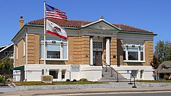
In 1988, the city embarked on a multi-million dollar plan to redevelop approximately 207 acres (0.8 km2) of land in the downtown core, and revitalize historic areas that had been in decline. [14] Projects included the Vernon Streetscape Project, Atlantic Street Beautification, Civic Plaza Complex, Downtown Vernon Street and Historic Old Town, Historic Old Town Streetscape project, Riverside Avenue Streetscape project, Oak Street Improvement Project, and Washington Boulevard pedestrian underpass. [15] A new parking garage opened in 2007, the Roseville Arts! Blueline Gallery opened in 2008, and a new Civic Center opened in 2013. The Vernon Street Town Square now features a small raised stage, a water spray for children, and a venue for community events.[ citation needed ]

Incidents

In 1995, a Roseville police officer shot and killed another officer, Mark A. White, during an attack at the city's police station. White (in plain clothes) drew his weapon against the assailant, but another officer mistakenly believed White was also an assailant and shot and killed him. [16]

On October 21, 2010, a young man set fires inside the Westfield Galleria at Roseville resulting in major damage to the mall. It reopened the next year after renovations. [17]

Geography

According to the Roseville Civic Center, the city has a total area of 42.26 square miles (109.5 km2), of which 42.24 square miles (109.4 km2) is land. 0.002 square miles, or 1 acre (0.40 ha), is water. Several streams flow through Roseville, including Dry Creek, Linda Creek, Secret Ravine and Cirby Creek.

Climate

Roseville has a hot-summer Mediterranean climate that is characterized by cool, wet, usually snowless winters and hot, dry summers (Köppen Csa). The climate is similar to nearby Sacramento, the minor differences reflecting Roseville’s more inland position, resulting in less of the moderating influence of the ocean. As a result, winters are slightly cooler and summers are slightly hotter than Sacramento.

The wet season is generally October through April. Because Roseville is east of Sacramento and at a higher elevation, it receives slightly more rainfall. The dry season lasts from June to October; similar to other Central Valley cities, temperatures can be extremely hot in the summer (routinely peaking above 105 °F (41 °C) on the hottest days), unusual for a non-desert climate at mid-latitude. Average daily high temperatures range from 53 °F (12 °C) in January to 94 °F (34 °C) in July. Daily low temperatures range from 39 °F (4 °C) in winter to 61 °F (16 °C) in summer.

On March 26, 2014, an EF0 tornado touched down in Roseville. [18] [19]

Climate data for Roseville, California
MonthJanFebMarAprMayJunJulAugSepOctNovDecYear
Record high °F (°C)75
(24)
78
(26)
86
(30)
98
(37)
107
(42)
110
(43)
115
(46)
110
(43)
115
(46)
102
(39)
87
(31)
76
(24)
115
(46)
Mean daily maximum °F (°C)53
(12)
60
(16)
64
(18)
71
(22)
80
(27)
88
(31)
94
(34)
92
(33)
87
(31)
77
(25)
63
(17)
54
(12)
74
(23)
Daily mean °F (°C)46
(8)
51
(11)
54
(12)
60
(16)
66
(19)
73
(23)
78
(26)
76
(24)
73
(23)
65
(18)
54
(12)
47
(8)
62
(17)
Mean daily minimum °F (°C)39
(4)
42
(6)
44
(7)
48
(9)
53
(12)
58
(14)
61
(16)
61
(16)
58
(14)
52
(11)
44
(7)
39
(4)
50
(10)
Record low °F (°C)21
(−6)
23
(−5)
27
(−3)
33
(1)
36
(2)
43
(6)
48
(9)
46
(8)
41
(5)
31
(−1)
27
(−3)
16
(−9)
16
(−9)
Average precipitation inches (mm)3.98
(101)
3.46
(88)
3.07
(78)
1.58
(40)
0.58
(15)
0.12
(3.0)
0.04
(1.0)
0.06
(1.5)
0.35
(8.9)
1.08
(27)
2.80
(71)
3.33
(85)
20.45
(519.4)
Source: http://www.myforecast.com/bin/climate.m?city=12133&metric=false

Demographics

Historical population
CensusPop.Note
1870 115
1880 258124.3%
1890 34533.7%
1910 2,608
1920 4,47771.7%
1930 6,42543.5%
1940 6,6533.5%
1950 8,72331.1%
1960 13,42153.9%
1970 18,22135.8%
1980 24,34733.6%
1990 44,68583.5%
2000 79,92178.9%
2010 118,78848.6%
2020 147,77324.4%
U.S. Decennial Census [20]

2020

Roseville, California – Racial and ethnic composition
Note: the US Census treats Hispanic/Latino as an ethnic category. This table excludes Latinos from the racial categories and assigns them to a separate category. Hispanics/Latinos may be of any race.
Race / Ethnicity (NH = Non-Hispanic)Pop 2000 [21] Pop 2010 [22] Pop 2020 [23] % 2000% 2010% 2020
White alone (NH)63,73784,34990,34779.75%71.01%61.14%
Black or African American alone (NH)9922,1573,5401.24%1.82%2.40%
Native American or Alaska Native alone (NH)4085685200.51%0.48%0.35%
Asian alone (NH)3,3709,78518,3224.22%8.24%12.40%
Pacific Islander alone (NH)1352944750.17%0.25%0.32%
Other race alone (NH)1032447340.13%0.21%0.50%
Mixed race or Multiracial (NH)1,9514,0329,7782.44%3.39%6.62%
Hispanic or Latino (any race)9,22517,35924,05711.54%14.61%16.28%
Total79,921118,788147,773100.00%100.00%100.00%

2010

The 2010 United States Census [24] reported that Roseville had a population of 118,788. The population density was 3,279.4 inhabitants per square mile (1,266.2/km2). The racial makeup of Roseville was 94,199 (79.3%) White, 2,329 (2.0%) African American, 885 (0.7%) Native American, 10,026 (8.4%) Asian (3.1% Filipino, 2.0% Indian, 1.0% Chinese, 0.6% Japanese, 0.6% Vietnamese, 0.5% Korean, 0.8% Other), 346 (0.3%) Pacific Islander, 5,087 (4.3%) from other races, and 5,916 (5.0%) from two or more races. There were 17,359 people of Hispanic or Latino ancestry, of any race (14.6%).

The Census reported that 117,941 people (99.3% of the population) lived in households, 478 (0.4%) lived in non-institutionalized group quarters, and 369 (0.3%) were institutionalized.

There were 45,059 households, out of which 16,885 (37.5%) had children under the age of 18 living in them, 24,050 (53.4%) were opposite-sex married couples living together, 4,901 (10.9%) had a female householder with no husband present, 2,088 (4.6%) had a male householder with no wife present. There were 2,518 (5.6%) unmarried opposite-sex partnerships, and 286 (0.6%) same-sex married couples or partnerships. 11,042 households (24.5%) were made up of individuals, and 4,502 (10.0%) had someone living alone who was 65 years of age or older. The average household size was 2.62. There were 31,039 families (68.9% of all households); the average family size was 3.14.

The age distribution of the population shows 31,210 people (26.3%) under the age of 18, 9,397 people (7.9%) aged 18 to 24, 33,362 people (28.1%) aged 25 to 44, 28,952 people (24.4%) aged 45 to 64, and 15,867 people (13.4%) who were 65 years of age or older. The median age was 36.8 years. For every 100 females, there were 91.9 males. For every 100 females age 18 and over, there were 88.4 males.

There were 47,757 housing units at an average density of 1,318.4 per square mile (509.0/km2), of which 29,513 (65.5%) were owner-occupied, and 15,546 (34.5%) were occupied by renters. The homeowner vacancy rate was 2.3%; the rental vacancy rate was 6.8%. 79,887 people (67.3% of the population) lived in owner-occupied housing units and 38,054 people (32.0%) lived in rental housing units.

2005

As of 2005, there were 103,845 people, 42,538 households, and 21,855 families residing in the city. The population density was 2,622.5 inhabitants per square mile (1,012.6/km2). There were 31,925 housing units at an average density of 1,047.6 per square mile (404.5/km2). The racial makeup of the city in 2010 was 71.0% non-Hispanic White, 1.8% non-Hispanic African American, 0.5% Native American, 8.2% Asian, 0.2% Pacific Islander, 0.2% from other races, and 3.4% from two or more races. Hispanic or Latino of any race were 14.6% of the population.

There were 30,783 households, out of which 35.4% had children under the age of 18 living with them, 57.1% were married couples living together, 10.1% had a female householder with no husband present, and 29.0% were non-families. 23.1% of all households were made up of individuals, and 9.2% had someone living alone who was 65 years of age or older. The average household size was 2.57 and the average family size was 3.03.

In the city, the age distribution of the population shows 26.8% under the age of 18, 7.0% from 18 to 24, 30.8% from 25 to 44, 21.0% from 45 to 64, and 14.5% who were 65 years of age or older. The median age was 36 years. For every 100 females, there were 92.1 males. For every 100 females age 18 and over, there were 88.8 males.

According to a 2007 estimate, the median income for a household in the city was $68,273, and the median income for a family was $84,863 [25] Males had a median income of $50,426 versus $35,494 for females. The per capita income for the city was $47,021. About 3.4% of families and 4.9% of the population were below the poverty line, including 5.3% of those under age 18 and 4.1% of those age 65 or over.

Economy

The city of Roseville has a variety of businesses. It has encouraged the addition of large retail centers, including one of the largest auto malls in the country, [26] [27] which contributes significantly to sales tax receipts at the city and county level. Revenue from sales tax has been a main reason why the city of Roseville has been able to keep up the city's infrastructure as the population has dramatically increased. This environment has produced a mix of housing, small and large employers, as well as shopping opportunities. A popular water park, Roseville Golfland SunSplash, is also located in Roseville. Companies based in the city include financial technology unicorn GoodLeap, which specializes in loans for residential solar energy.

Retail Commerce

Shopping plays a vital role in the economy of Roseville, which has the thirteenth highest retail sales of all California cities. [28] Roseville is considered a regional shopping destination, with the Westfield Galleria at Roseville being the main shopping center in the city and the second-largest shopping mall in Northern California. Westfield embarked on a 487,806-square-foot (45,319 m2) expansion project costing $270 million, because of the revenue they acquire from this high-end [29] mall.

Across the street from the Galleria, Peter Bollinger Investment Company built a $70 million complex named "Fountains at Roseville". [30] Fountains at Roseville is a 330,000 sq ft (31,000 m2) retail center that includes recreation centers. The first phase opened to the public on June 30, 2008, and includes many retailers, as well as a vast variety of casual and fine dining options. [31] Plans call for future construction of hotel, additional retail, and office buildings as well.

In addition to the Galleria and Fountains at Roseville, the city has many shopping plazas surrounding the Galleria and the Douglas Boulevard financial corridor.

Major employers

The top ten employers of the city as of 2017 are: [32]

EmployerNumber of jobs
Kaiser Permanente 4,988
Hewlett Packard Enterprise 2,300
Sutter Roseville Medical Center 2,100
Union Pacific Railroad 1,150
City of Roseville1,149
Roseville Joint Union High School District 1,090
Roseville City School District1,034
PRIDE Industries838
Adventist Health 801
Consolidated Communications 440

Education

Public schools

Roseville is part of the Roseville City School District, Eureka Union School District, Dry Creek Joint Elementary School District, and Roseville Joint Union High School District.

Colleges and universities

Extension campuses of Brandman University and Sierra College (called "Roseville Center") are located in Roseville. [33] [34]

Media

Rocklin and Roseville Today is a daily online newspaper. The Roseville Press-Tribune is a local weekly newspaper.

Roseville High School's student-run news organization, Eye of the Tiger, publishes the bimonthly Eye of the Tiger newspaper. It also produces the biweekly Eye of the Tiger News broadcast. [35] [36]

The Sacramento Bee is also distributed in Roseville. Style Magazine, founded in 2003, is the area's largest circulation general interest, monthly magazine.

Infrastructure

Transportation

Two highways run through the city: Interstate 80 and State Route 65 (the southern terminus of which connects to I-80).

Amtrak, the national passenger rail system, provides service to Roseville at the Roseville Amtrak Station and is part of the Capitol Corridor.

Roseville Transit is a public transit service overseen by the city of Roseville and operated by MV Transportation. The system provides a total of 12 regular local routes, as well as the Roseville Transit Dial-A-Ride (DAR) and Roseville Transit Commuter service. There are several stops where connections may be made with the Sacramento Regional Transit line and Placer County Transit. [37]

Placer County Transit connects Roseville with the Watt/I-80 RT light rail station, as well as the cities of Auburn, Lincoln, Rocklin, and other cities along the Interstate 80 corridor. The Placer Commuter Express service to Sacramento also serves the Taylor Rd. park and ride lot. [38]

Utilities

The City of Roseville provides electric, water, wastewater, and solid waste services to most areas. In February 2020, 75 project customers, including Roseville, received permanent federal water contracts for the Central Valley Project. [39] [40]

Pacific Gas and Electric provides natural gas service. Internet, cable, and/or telephone companies that service the Roseville area include AT&T, Comcast, and Consolidated Communications.

Healthcare

Major healthcare providers in the city include Sutter Roseville and Kaiser Permanente. There are multiple smaller clinics located near or around the city. UC Davis Medical Center is also located in nearby Sacramento.

Fire department

The Roseville Fire Department provides fire protection and emergency medical services. The department is responsible for an area of 36 square miles (93 km2) housing a population of 118,788 as of 2010.

The department has 8 stations with a single battalion. [41]

Notable people

Residents

Natives

See also

Related Research Articles

<span class="mw-page-title-main">Sacramento County, California</span> County in California, United States

Sacramento County is a county located in the U.S. state of California. As of the 2020 census, the population was 1,585,055. Its county seat is Sacramento, which has been the state capital of California since 1854.

<span class="mw-page-title-main">Placer County, California</span> County in California, United States

Placer County, officially the County of Placer, is a county located in the U.S. state of California. As of the 2020 census, the population was 404,739. The county seat is Auburn.

<span class="mw-page-title-main">Sutter County, California</span> County in California, United States

Sutter County is a county located in the U.S. state of California. As of the 2020 census, the population was 99,633. The county seat is Yuba City. Sutter County is included in the Yuba City, CA Metropolitan Statistical Area as well as the Sacramento-Roseville, CA Combined Statistical Area. The county is located along the Sacramento River in the Sacramento Valley.

<span class="mw-page-title-main">Colfax, California</span> City in California, United States

Colfax is a city in Placer County, California, at the crossroads of Interstate 80 and State Route 174. The population was 1,963 at the 2010 census. The town is named in honor of U.S. Vice President Schuyler Colfax (1869–73), a bronze statue of whom stands at Railroad Street and Grass Valley Street.

<span class="mw-page-title-main">Granite Bay, California</span> Census-designated place in California, United States

Granite Bay is a census-designated place (CDP) in Placer County, California, United States. It is part of the Sacramento–Arden-Arcade–Roseville Metropolitan Statistical Area. The population was 21,247 at the 2020 census, up from 20,402 at the 2010 census. The ZIP codes are 95746 and 95661. Granite Bay is a primarily residential suburb of Sacramento and is located just east of Roseville and west of Folsom Lake.

<span class="mw-page-title-main">Lincoln, California</span> City in California, United States

Lincoln is a city in Placer County, California, United States, part of the Sacramento metropolitan area. Located ten miles north of Roseville in an area of rapid suburban development, it grew 282 percent between 2000 and 2010, making it the fastest-growing city over 10,000 people in the U.S. Its 2019 population was estimated to be 48,275.

<span class="mw-page-title-main">Loomis, California</span> City in California, United States

Loomis is an incorporated town in Placer County, California, United States. It is part of the Sacramento–Arden-Arcade–Roseville Metropolitan Statistical Area. The town's population was reported as 6,836 in the 2020 United States Census. It shares borders with the city of Rocklin and the Census-Designated Places Penryn and Granite Bay.

<span class="mw-page-title-main">North Auburn, California</span> Census-designated place in California, United States

North Auburn is a census-designated place (CDP) in Placer County, California, United States. It is part of the Sacramento–Arden-Arcade–Roseville Metropolitan Statistical Area. The population was 13,452 at the 2020 census.

<span class="mw-page-title-main">Rocklin, California</span> City in California, United States

Rocklin is a city in Placer County, California, about 22 miles (35 km) from Sacramento, and about 6.1 miles (9.8 km) northeast of Roseville in the Sacramento metropolitan area. Besides Roseville, it shares borders with Granite Bay, Loomis and Lincoln. As of the 2020 census, Rocklin's population was 71,601.

<span class="mw-page-title-main">Citrus Heights, California</span> City in California, United States

Citrus Heights is a city in Sacramento County, California, United States. As of the 2020 U.S. Census, the city had a population of 87,583, up from 83,301 at the 2010 U.S. Census.

<span class="mw-page-title-main">Folsom, California</span> City in California, United States

Folsom is a city in Sacramento County, California, United States. The population was 80,454 at the 2020 census.

<span class="mw-page-title-main">Gold River, California</span> Census-designated place in California, United States

Gold River is a census-designated place (CDP) in Sacramento County, California. The population was 7,812 at the 2010 census, down from 8,023 at the 2000 census. Gold River is part of the Sacramento–Arden-Arcade–Roseville Metropolitan Statistical Area. With a median family income of $141,399 according to U.S Census Bureau in 2021, Gold River is the highest-income place in Sacramento County.

<span class="mw-page-title-main">La Riviera, California</span> Census-designated place in California, United States

La Riviera is a census-designated place (CDP) in Sacramento County, California, United States. It is part of the Sacramento–Arden-Arcade–Roseville Metropolitan Statistical Area. The population was 10,802 at the 2010 census, up from 10,273 at the 2000 census. La Riviera is a primarily residential neighborhood located between the American River on the North side and Highway 50 on the southern border.

<span class="mw-page-title-main">North Highlands, California</span> Census-designated place in California, United States

North Highlands is a census-designated place (CDP) in Sacramento County, California, United States. It is part of the Sacramento–Arden-Arcade–Roseville Metropolitan Statistical Area. The population was 42,694 at the 2010 census, down from 44,187 at the 2000 census.

<span class="mw-page-title-main">Orangevale, California</span> Census-designated place in California, United States

Orangevale is a census-designated place (CDP) in Sacramento County, California, United States. It is part of the Sacramento–Arden-Arcade–Roseville Metropolitan Statistical Area. The population was 33,960 at the 2010 census, up from 26,705 at the 2000 census. It is located approximately 25 miles (40 km) northeast of Sacramento. The community is known for its rolling hills that offer the best views of the Sierra Nevada mountain range, its foothills, and a rural environment in the middle of a growing metropolitan area. Some residential properties in the area are zoned to accommodate horses and orchards. It has a ZIP Code of 95662.

<span class="mw-page-title-main">Parkway–South Sacramento, California</span> Unincorporated community in California, United States

Parkway–South Sacramento is a former census-designated place (CDP) in Sacramento County, California, United States. It is part of the Sacramento–Arden-Arcade–Roseville Metropolitan Statistical Area. The area shares three boundaries with the City of Sacramento. The population was 36,468 at the 2000 census.

<span class="mw-page-title-main">Rosemont, California</span> Census-designated place in California, United States

Rosemont is a census-designated place (CDP) in Sacramento County, California, United States. It is part of the Sacramento–Arden-Arcade–Roseville metropolitan area. The population rose to 23,510 at the 2020 census. It was 22,681 at the 2010 census, down from 22,904 at the 2000 census.

<span class="mw-page-title-main">Suisun City, California</span> City in California, United States

Suisun City is a city in Solano County, California, United States. The population was 29,518 at the 2020 census.

<span class="mw-page-title-main">West Sacramento, California</span> City in Yolo County, California, United States

West Sacramento is a city in Yolo County, California, United States. The city is separated from Sacramento by the Sacramento River, which also separates Sacramento and Yolo counties. It is a fast-growing community; the population was 53,915 at the 2020 census, up from 48,744 at the 2010 census. The traditional industrial center of the region since the Gold Rush era, West Sacramento is home to a diverse economy and is one of the area's top four employment centers.

Elverta is a census-designated place in Sacramento County, California. It is part of the Sacramento metropolitan area, which includes Sacramento, Arden-Arcade, and Roseville. It is about 20 miles (32 km) from Sacramento, 2.5 miles (4.0 km) from Rio Linda, 6 miles (9.7 km) from Roseville, and 8.0 miles (12.9 km) from Antelope. The population was 5,492 as of the 2010 census.

References

  1. "California Cities by Incorporation Date". California Association of Local Agency Formation Commissions. Archived from the original (Word) on February 21, 2013. Retrieved August 25, 2014.
  2. 1 2 "City Council/Mayor".
  3. 1 2 "Statewide Database". UC Regents. Archived from the original on February 1, 2015. Retrieved November 21, 2014.
  4. "California's 4th Congressional District - Representatives & District Map". Civic Impulse, LLC. Retrieved March 3, 2013.
  5. "2019 U.S. Gazetteer Files". United States Census Bureau. Retrieved July 1, 2020.
  6. "Roseville". Geographic Names Information System . United States Geological Survey, United States Department of the Interior . Retrieved March 15, 2015.
  7. "Roseville (city) QuickFacts". United States Census Bureau. Archived from the original on September 5, 2012. Retrieved March 15, 2015.
  8. 1 2 "Population and Housing Unit Estimates" . Retrieved May 21, 2020.
  9. 1 2 Durham, David L. (1998). California's Geographic Names: A Gazetteer of Historic and Modern Names of the State. Clovis, Calif.: Word Dancer Press. p. 548. ISBN   1-884995-14-4.
  10. "Archived copy: History of Roseville". Archived from the original on May 17, 2014. Retrieved June 11, 2014. In 1864, a track-laying crew from the Central Pacific Railroad came eastward across the plain from Sacramento, building the western half of the nation's first transcontinental railroad. They crossed a small rail line (the California Central Railroad) that linked the young towns of Lincoln and Folsom, and gave the spot the imaginative name of Junction.
  11. "City of Roseville, California - 1920s". March 2, 2013. Archived from the original on March 2, 2013. Retrieved August 26, 2021.
  12. "The Roseville Explosion--". Archived from the original on July 23, 2006. Retrieved June 28, 2006.
  13. "City of Roseville, California - Population". March 8, 2010. Archived from the original on March 8, 2010. Retrieved August 26, 2021.
  14. Environmental Impact Report for the Roseville Redevelopment Project, Earth Metrics, prepared for City of Roseville and State of California Clearinghouse, May 1989
  15. "City of Roseville, California - Improvement & Construction Projects". August 1, 2012. Archived from the original on August 1, 2012. Retrieved August 26, 2021.
  16. Thigpen/Appeal-Democrat, Daniel. "Officer Mark A. White left behind a wife and two children". Appeal-Democrat. Retrieved February 23, 2022.
  17. "Grand Re-Opening Of Roseville Galleria Set For October 6". CBS Sacramento. August 23, 2011.
  18. "Roseville Tornado Strike Damages Homes". Roseville Today. March 27, 2014. Retrieved January 12, 2022.
  19. Medina, Maria (March 26, 2014). "Tornado Damages Dozens Of Roseville Homes". CBS Sacramento. Retrieved January 12, 2022.
  20. "Census of Population and Housing". Census.gov. Retrieved June 4, 2015.
  21. "P004: Hispanic or Latino, and Not Hispanic or Latino by Race – 2000: DEC Summary File 1 – Roseville city, California". United States Census Bureau. Retrieved January 26, 2024.
  22. "P2: Hispanic or Latino, and Not Hispanic or Latino by Race – 2010: DEC Redistricting Data (PL 94-171) – Roseville city, California". United States Census Bureau. Retrieved January 26, 2024.
  23. "P2: Hispanic or Latino, and Not Hispanic or Latino by Race – 2020: DEC Redistricting Data (PL 94-171) – Roseville city, California". United States Census Bureau. Retrieved January 26, 2024.
  24. "2010 Census Interactive Population Search: CA - Roseville city". U.S. Census Bureau. Archived from the original on July 15, 2014. Retrieved July 12, 2014.
  25. "Roseville 2007 Income Estimates". Archived from the original on February 12, 2020. Retrieved May 3, 2009.
  26. "Welcome to Roseville! We are glad you are here! | Roseville Area Chamber of Commerce". Roseville Area Chamber of Commerce |. March 1, 2021. Retrieved December 1, 2022.
  27. "Roseville California Dealership | Roseville Automall". www.rosevilleautomall.com. Retrieved December 1, 2022.
  28. "City of Roseville – Retail" . Retrieved July 28, 2012.
  29. "City of Roseville Planning Commission Report" (PDF). June 22, 2006.
  30. Jon, Ortiz (July 4, 2008). "Fountains in full flow". The Sacramento Bee. Archived from the original on December 3, 2008. Retrieved December 3, 2008.
  31. Sorich, Sonya (May 8, 2015). "What's being built at Roseville's Fountains?". American City Business Journals .
  32. City of Roseville, California - Comprehensive Annual Financial Report (CAFR)
  33. "College in Roseville, CA | Brandman University". www.brandman.edu. Retrieved March 7, 2021.
  34. "Sierra College: About Us". 2021.
  35. "Eye of the Tiger - Roseville High School's independent student press". Eye of the Tiger. Retrieved May 4, 2019.
  36. "Eye of the Tiger". YouTube. Retrieved May 4, 2019.
  37. City of Roseville, California - Fixed Route
  38. "Placer County Transit". Archived from the original on October 14, 2008. Retrieved October 12, 2008.
  39. Boxall, Bettina (February 29, 2020). "Westlands Water District gets permanent U.S. contract for massive irrigation deliveries". Los Angeles Times . Retrieved March 2, 2020.
  40. "Bureau of Reclamation Completes First Group of Congressionally-Mandated California Central Valley Project Contract Conversions". Sierra Sun Times. March 2, 2010. Retrieved March 3, 2020.
  41. "Stations". Roseville Fire Department. Retrieved April 22, 2015.
  42. Virginia Pilot. “FIRST WOMAN GUARDS TOMB OF UNKNOWNS ``THERE IS NO HIGHER HONOR OR GREATER HONOR, SAYS NATIVE CALIFORNIAN, 23.” Saturday, March 23, 1996. https://scholar.lib.vt.edu/VA-news/VA-Pilot/issues/1996/vp960323/03230285.htm
  43. News & record. “1ST WOMAN GUARDS UNKNOWN SOLDIER.” Knight-Ridder News Service. March 22, 1996, Updated January 28, 2015. https://greensboro.com/1st-woman-guards-unknown-soldier/article_425e774d-089b-5c3e-9576-0ba767ae41d2.html