Ophir, California

Last updated

Ophir
California Locator Map with US.PNG
Red pog.svg
Ophir
Location in California
Usa edcp location map.svg
Red pog.svg
Ophir
Ophir (the United States)
Coordinates: 38°53′28″N121°07′25″W / 38.89111°N 121.12361°W / 38.89111; -121.12361
Country Flag of the United States.svg  United States
State Flag of California.svg  California
County Placer County
Elevation
[1]
682 ft (208 m)
Reference no.463

Ophir (also, Spanish Corral [1] and Ophirville [2] ) is an unincorporated community in Placer County, California. [1]

Contents

Ophir is located 2.5 miles (4.0 km) west of Auburn. [2] It lies at an elevation of 682 feet (208 m). [1]

Ophir addresses have the ZIP code of 95658, a Newcastle address. [3]

History

Ophir was a boomtown of the California Gold Rush. Originally named The Spanish Corral in 1849, [4] Ophir received its Biblical name Ophir, the source of King Solomon's treasures, in 1850 because of the rich gold placer mining in the area. [2] In 1852 it was the center of the local gold mining industry, and the most populous town in the county.

It grew to over 500 families by 1853, when a disastrous fire on the 12th of July destroyed the whole town. [5] [6] The town was not rebuilt at the time. Later Ophir became the center of quartz mining in the county. It is remembered at California Historical Landmark #463. [7]

The Ophirville post office was open by 1852 and closed in 1866. [2] The Ophir post office opened in 1872 and closed in 1910. [2]

After the gold rush, the area was planted in vineyards and orchards, and during Prohibition just in orchards. Beginning in the 1970s vineyards again returned to the area. Today, local services for Ophir come from Auburn.

Related Research Articles

<span class="mw-page-title-main">Cherokee, California</span> Unincorporated community in California, United States

Cherokee is an unincorporated community and census-designated place in Butte County, California. It is an area inhabited by Maidu Indians prior to the gold rush, but that takes its name from a band of Cherokee prospectors who perfected a mining claim on the site. The population was 69 at the 2010 census. It lies at an elevation of 1306 feet.

<span class="mw-page-title-main">Bidwell's Bar, California</span> Former settlement in California, United States

Altaville is a former unincorporated community in Calaveras County, California, now located in the northwest portion of the city of Angels Camp. It sits at an elevation of 1,542 feet above sea level and is located at 38°05′02″N120°33′43″W, at the intersections of SR 49 and SR 4. The community is in ZIP code 95221 and area code 209.

<span class="mw-page-title-main">El Dorado, California</span> Unincorporated community in California, United States

<span class="mw-page-title-main">Cool, California</span> Unincorporated community in California, United States

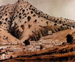
Mount Ophir is a ghost town in Mariposa County, California. It was a mining town founded in 1850 during the California Gold Rush, and was the site of the Mount Ophir Mint, the first authorized mint in California.

<span class="mw-page-title-main">French Corral, California</span> Unincorporated community in California, United States

French Corral is an unincorporated community approximately five miles west of California State Highway 49 in Nevada County, California, United States.

<span class="mw-page-title-main">Havilah, California</span> Unincorporated community in California, United States

Havilah is an unincorporated community in Kern County, California. It is located in the mountains between Walker Basin and the Kern River Valley, 5 miles (8.0 km) south-southwest of Bodfish at an elevation of 3,136 feet (956 m).

North Columbia was a California Gold Rush town on the San Juan Ridge in Nevada County, California. Originally known as Columbia, Columbia Hill, or The Hill because of its proximity to Columbia Hill, it started as a gold miners' camp around 1851. When a Post Office was established on May 29, 1860, the word "North" was added in order to differentiate the settlement from Columbia, California, another gold rush town in Tuolumne County, California.

<span class="mw-page-title-main">North San Juan, California</span> Census-designated place in California, United States

North San Juan is a census-designated place in Nevada County, California, United States, along State Route 49 on the San Juan Ridge in Gold Country. The zip code is 95960. The population was 269 at the 2010 census.

Cherokee is a former gold mining community in Nevada County, California. As explained below, it has also been known as Patterson, Melrose and Tyler. It is located on the San Juan Ridge about 4 miles east of North San Juan. Its elevation is 2,516 ft (767 m) above sea level.

Little York is the name of one of the first gold mining towns established in Nevada County, California as well as the name of the township in which it was situated. The town was located on the Lowell Ridge between Steephollow Creek and the Bear River, about 13 miles east of Nevada City, California and about 1 mile southwest of Dutch Flat, California at an elevation of about 2800 feet.

<span class="mw-page-title-main">Gold Run, California</span> Former settlement in California, United States

Gold Run was a former mining town of the California Gold Rush, located in Placer County, California.

<span class="mw-page-title-main">Red Mountain, California</span> Unincorporated community in California, United States

Red Mountain, formerly known as Osdick, is an unincorporated community in San Bernardino County, California, United States.

Yankee Jims is a small community in Placer County, California.

Gold Hill is an unincorporated community in Placer County, California. Gold Hill is located 6 miles (9.7 km) west of Auburn. It lies at an elevation of 354 feet.

References

  1. 1 2 3 4 U.S. Geological Survey Geographic Names Information System: Ophir, California
  2. 1 2 3 4 5 Durham, David L. (1998). California's Geographic Names: A Gazetteer of Historic and Modern Names of the State. Clovis, Calif.: Word Dancer Press. p. 533. ISBN   1-884995-14-4.
  3. Zip Code Lookup
  4. Gudde, Erwin. 1975. California Gold Camps. University of California Press: Berkeley. pp. 252-253.
  5. Seacrest, William B. (2005). California Disasters, 1812-1899. Sanger, California: Quill Driver Books. p.  234. ISBN   978-1-884995-49-1.
  6. "The Ophir Fire: Additional Particulars". Sacramento Daily Union. Vol. 5, no. 720. July 15, 1853. p. 1, column 4.
  7. "Ophir". Office of Historic Preservation, California State Parks. Retrieved October 11, 2012.