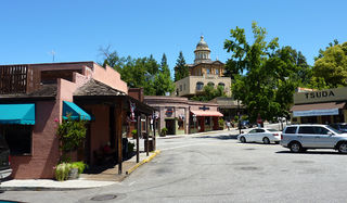
Auburn is a city in and the county seat of Placer County, California. Its population was 13,330 during the 2010 census. Auburn is known for its California Gold Rush history, and is registered as a California Historical Landmark.

Aguanga is a census-designated place located within the Inland Empire, Riverside County, California. It is located about 18 miles (29 km) east of Temecula and 22 miles (35 km) south-southeast of Hemet. Aguanga lies at an elevation of 1955 feet. As of the 2010 census, it had a population of 1,128.

Boyds, Maryland is an unincorporated community in rural Montgomery County, Maryland, located about 20 miles (32 km) north of Washington, D.C. Its ZIP Code is 20841.

Applegate is an unincorporated community in Placer County, California. It is 7.25 mi (11,670 m) south-southwest of Colfax, and 9.3 mi (15.0 km) northeast of Auburn. The city's msl elevation is 2,005 ft (611 m). Its ZIP code is 95703 and its area code 530.

Campo is a census-designated place (CDP) located in the Mountain Empire area of southeastern San Diego County, California. The population was 2,684 at the 2010 census.

Railroad Wars were business rivalries between railroad companies, which occurred frequently in American history. Although they were usually little more than legal disputes inside a courtroom, they sometimes turned into armed conflicts. There has been competition between railroad companies since the beginning of railroading in the United States, but violent confrontations were most common in the final quarter of the 19th century, particularly in the Old West.

Olema is an unincorporated community in Marin County, California. It is located on Olema Creek 2.25 miles (3.6 km) south-southeast of Point Reyes Station, at an elevation of 69 feet.

Helendale or Silver Lakes is an unincorporated community and census-designated place located in the Victor Valley of the Mojave Desert, within San Bernardino County, California.

Agate is an unincorporated community and U.S. Post Office in Elbert County, Colorado, United States. The ZIP Code of the Agate Post Office is 80101.
Secret Ravine is a perennial tributary of Miners Ravine which shortly thereafter runs into Dry Creek in Placer County, California. Its course lies within the cities of Rocklin, Loomis, and Roseville, as well as unincorporated parts of Placer County. It passes through the campus of Sierra College. Over its entire length the creek runs near the Interstate 80 freeway. It is an area becoming increasingly suburbanized. It was the site of placer mining operations during the California Gold Rush, and areas of tailings remain to this day. Later the drainage was a locale for granite quarrying.
Meyers is a small unincorporated community in El Dorado County, California, United States, along U.S. Route 50 in the northern Sierra Nevada mountains 6 miles south of South Lake Tahoe in the Lake Tahoe area. It lies at an elevation of 6,352 feet. Established in 1851, Meyers started out as a stagecoach stop, trading post and Pony Express station. The town is now registered as California Historical Landmark #708. It serves as a popular stop on the way into and out of the Tahoe Basin for travelers on Highways 50 and 89.

Patchen is a ghost town nestled in the Santa Cruz Mountains, in unincorporated west Santa Clara County, California. It is located along the Old Santa Cruz Highway, east of State Route 17.
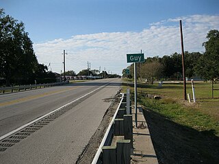
Guy is an unincorporated community in Fort Bend County, Texas, United States. It is located on Texas State Highway 36 (SH 36) about 16 miles (26 km) south of Rosenberg, Texas. A trucking company, a Shell Oil Company filling station, a post office, and several homes are located near the intersection of SH 36 and Farm to Market Road 1994 (FM 1994). The community was established in 1890 and was served by a railroad between 1918 and the 1980s.
Chicago Park is a high-end residential and unincorporated historic agricultural and wine-growing community in Nevada County, California. It is located along Highway 174, with its center at the intersection of Mt. Olive Road. The neighborhood gets its name from its founding residents, who came from Chicago to California in the late 1800s to grow wine, which was often shipped back to Illinois for consumption. As one of California's first wine-growing regions, Chicago park is about 9 miles southeast of Grass Valley and about 3 miles north of Colfax.
Willow Ranch is an unincorporated community in Modoc County, California. It is 33.3 miles (54 km) north-northeast of Alturas, at an elevation of 4731 feet.
The lost towns are a group of places that are still commonly used by county residents. Each was at one time a post office, a store that served a part of the county, a grain elevator used by farmers to ship their crops, or a development that was or may still remain a unique designation. There may be a residential association or some other legal body devoted to the area. More often, these communities are communities of people who still refer to their homes by these geographic designations.
The Auburn Trail is a multi-use rail trail located principally in the towns of Victor and Farmington, Ontario County, New York (USA). It is approximately 11 miles (18 km) long and maintained by the Towns of Victor and Farmington and Victor Hiking Trails. The trail mostly follows the alignment of the Auburn and Rochester Railroad. Additional disconnected portions of the Auburn trail are found in the Towns of Pittsford and Brighton, Monroe County, NY. A detailed description and map of the Auburn Trail are available from Victor Hiking Trails.
Willow Springs Station, was a changing station at Alamos or Willow Springs along the Second Division route of the Butterfield Overland Mail, in what is now Murrieta, in Riverside County, California. It was also known as Alamos, Clines's or Kline's, or Willows, was one of the later Butterfield Overland Mail stations, placed in 1859, between some of the original stations for changing teams and providing water between stops in hot dry areas. Willow Springs, also originally known as Alamos Springs was located west of the hills that line the east side of the Temecula Valley, on land of the Rancho Temecula, near Santa Gertrudis Creek on the low flood plain of Murrieta Creek, between Santa Gertrudis and Warm Springs Creek.

Provident City is a ghost town in the far southern panhandle of Colorado County in the U.S. state of Texas. The former settlement is located along County Road 190. The town was first settled through a land promotion scheme in 1909 and enjoyed a brief heyday. When it was obvious the hoped-for railroad would never come to town, people began moving away. The post office closed in 1953 and most of the land was bought up for ranching. The town no longer exists though the original hotel survives in private hands. Reaching the site requires driving 4.3 miles (6.9 km) on a gravel road from the nearest highway.
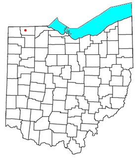
Emery is a ghost town in Dover Township, Fulton County, Ohio, near present-day Tedrow, Ohio.


