
Council Bluffs is a city in and the county seat of Pottawattamie County, Iowa, United States. The city is the most populous in Southwest Iowa, and forms part of the Omaha (Nebr.) Metropolitan Area. It is located on the east bank of the Missouri River, across from the city of Omaha. Council Bluffs was known, until at least 1853, as Kanesville. It was the historic starting point of the Mormon Trail. Kanesville is also the northernmost anchor town of the other emigrant trails, since there was a steam powered boat to ferry their wagons, and cattle, across the Missouri River.

Tehama County is a county located in the northern part of the U.S. state of California. As of the 2010 census, the population was 63,463. The county seat and largest city is Red Bluff.

Red Bluff is a city in and the county seat of Tehama County, California, United States. The population was 14,076 at the 2010 census, up from 13,147 at the 2000 census.

Scotts Bluff National Monument is located in the City of Gering in western Nebraska. This National Park Service site protects over 3,000 acres of historic overland trail remnants, mixed-grass prairie, rugged badlands, towering bluffs and riparian area along the North Platte River. The bluff served as an important landmark for pioneers on the Oregon Trail, California Trail, Mormon Trail and Pony Express Trail. The bluff is named after Hiram Scott, who was a clerk for William Ashley's Rocky Mountain Fur Company and died near the bluff in 1828. Over 250,000 westward emigrants passed by Scotts Bluff between 1843 and 1869. It was the second-most referred to landmark on the Oregon, California and Mormon trails in pioneer journals and diaries. Visitors to Scotts Bluff National Monument can walk in the footsteps of pioneers on remnants of the Oregon Trail, drive to the top of the bluff via the Summit Road, which is the oldest concrete road in the state of Nebraska and stand in awe at the sight of the bluffs raising from the prairie. The park boasts over 100,000 annual visitors.

Nemophila menziesii, known commonly as baby blue eyes or baby's-blue-eyes, is an annual herb, native to western North America.

Fitzgerald Marine Reserve is a marine reserve in California on the Pacific Ocean, located just north of Pillar Point Harbor and Mavericks in the San Mateo County community of Moss Beach. Moss Beach is located approximately 20 miles (32 km) south of San Francisco and 50 miles (80 km) north of Santa Cruz. The reserve is a 32-acre (0.13 km2) holding which extends from Montara light station at the north to Pillar Point on the south. The reserve consists of a three-mile stretch of beach, tidepool habitat, marsh, erosive bluffs, clifftop trail and cypress and eucalyptus forests. The property is owned by the State of California and managed by San Mateo County as a county park and nature preserve. The reserve is administratively assigned to be part of the Gulf of the Farallones National Marine Sanctuary. Adjacent to and possibly within the reserve is an endangered species of butterfly, the San Bruno elfin butterfly.

Manchester State Park is a state park of California, United States. It includes 18,000 feet (5,500 m) of protected beachfront on the Pacific Ocean in Northern California on State Route 1, 7 miles (11 km) north of Point Arena. The park features sand dunes, flat grasslands and five miles of gentle, sandy beachfront. The park is noted for steelhead and salmon fishing in the park's two streams, Brush Creek and Alder Creek, as well as the driftwood that collects in the catch basin created by the gently curved coastline. The 5,272-acre (2,134 ha) site was established as a California state park in 1955 and takes its name from Manchester, California, seven miles north of Point Arena.

Prairie Creek Redwoods State Park is a state park, located in Humboldt County, California, near the town of Orick and 50 miles (80 km) north of Eureka. The 14,000 acre (57 km²) park is a coastal sanctuary for old-growth Coast Redwood trees.
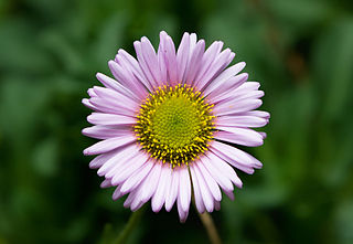
Erigeron glaucus is a species of flowering plant in the daisy family known by the common name seaside fleabane, beach aster, or seaside daisy.

Pomponio State Beach is a state beach of California in the United States. It is located 12 miles (19 km) south of Half Moon Bay off California State Route 1.

Prairie Bluff, also known as Dale and Daletown, is a ghost town in Wilcox County, Alabama.
Atsepar, also spelled Otsepor is a former Yurok people settlement in Humboldt County, California. Kroeber maps it on the Klamath River south of the confluence of Bluff Creek and the Klamath, but above the confluence with the Trinity River; its precise location is unknown.

Noyo is an unincorporated community in Mendocino County, California. It is located 1 mile (1.6 km) south of the center of Fort Bragg, at an elevation of 108 feet. It is named after the Noyo River, on which it lies; the Noyo River in turn was misnamed by white settlers to the Mendocino area after a village of the Pomo people named Noyo several miles north, on Pudding Creek. The Pomo named the creek after their village, and the settlers transferred the name to the larger river to the south.
San Elijo State Beach is a California State Beach in San Diego County, California, United States,

Phacelia californica is a species of phacelia known by the common names California phacelia and California scorpionweed. It is native to coastal northern California and Oregon, where it grows in chaparral, woodland, and coastal bluffs and grassland.

Red Bluff Air Force Station is a closed United States Air Force General Surveillance Radar station. It is located 4.3 miles (6.9 km) west-southwest of Red Bluff, California. It was closed in 1970.

Michigan Bluff is an unincorporated community in Placer County, California. Michigan Bluff is 4.35 miles (7.0 km) east-northeast of Foresthill. It is at an elevation of 3,510 feet (1,070 m).
Chalk Bluff is a former settlement in Nevada County, California.
Jug Handle State Natural Reserve is a state park unit of California, United States, preserving a series of marine terraces each exhibiting a different stage of ecological succession. It is located on California State Route 1 north of the village of Caspar, 5 miles (8.0 km) equidistant between the towns of Mendocino and Fort Bragg. The 776-acre (314 ha) park was established in 1976.
The Wiyot Tribe is a federally recognized tribe of Wiyot people. They are the aboriginal people of Humboldt Bay, Mad River, and lower Eel River.


