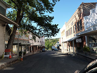
San Andreas is an unincorporated census-designated place and the county seat of Calaveras County, California. The population was 2,783 at the 2010 census, up from 2,615 at the 2000 census. Like most towns in the region, it was founded during the California Gold Rush. The town is located on State Route 49 and is registered as California Historical Landmark #252.
A census-designated place (CDP) is a concentration of population defined by the United States Census Bureau for statistical purposes only.

The Geographic Names Information System (GNIS) is a database of name and location information about more than two million physical and cultural features throughout the United States and its territories, Antarctica, and the associated states of the Marshall Islands, Federated States of Micronesia, and Palau. It is a type of gazetteer. It was developed by the United States Geological Survey (USGS) in cooperation with the United States Board on Geographic Names (BGN) to promote the standardization of feature names.
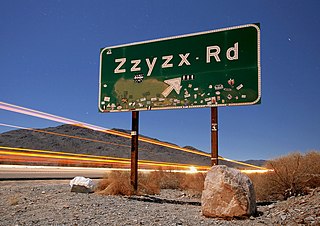
Zzyzx, formerly Soda Springs, is an unincorporated community in San Bernardino County, California, within the boundaries of the Mojave National Preserve, managed by the National Park Service (NPS), an agency of the U.S. Department of Interior, as public land. It is the former site of the Zzyzx Mineral Springs and Health Spa and now the site of the Desert Studies Center. The site is also the location of Lake Tuendae, originally part of the spa, and now a refuge habitat of the endangered Mohave tui chub.
Edwards is an unincorporated community in Kern County, California.
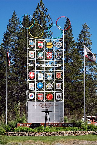
Olympic Valley is an unincorporated community located in Placer County, California northwest of Tahoe City along California State Highway 89 on the banks of the Truckee River near Lake Tahoe. It is home to Palisades Tahoe, the site of the 1960 Winter Olympics. Olympic Valley is the smallest resort area to host the Olympic Winter Games.

Caliente is an unincorporated community in Kern County, California. It is located 22 miles (35 km) east-southeast of Bakersfield, at an elevation of 1,312 feet (400 m).
Pacheco Creek is a 3.4-mile-long (5.5 km) waterway in central Contra Costa County, California. It empties into Suisun Bay.
Norden is a small unincorporated community in Nevada County, California, United States, about 9 miles (14 km) west of Truckee. The community is located on a former portion of U.S. Route 40 near Interstate 80 and lies along the historical First transcontinental railroad, 1.5 miles (2.4 km) west of Donner Pass.
This is a list of the National Register of Historic Places listings in San Bernardino County, California.
Goler Heights, also known simply as Goler, is an unincorporated community in Kern County, California. It is located 6.5 miles (10 km) northwest of Randsburg, at an elevation of 2,579 feet (786 m). The town is named after John Goller, a German immigrant who discovered a placer gold deposit that was later mined and named in his honor.
Cahto is a former settlement in Mendocino County, California. It was located 3 miles (4.8 km) southwest of Laytonville.
Cornell is an unincorporated community in the Santa Monica Mountains, within western Los Angeles County, California. It is located 5 miles (8.0 km) west of Agoura Hills and around 2.5 miles (4.0 km) north of Malibu.
Gabilan was a former settlement in Monterey County, California. It was located on the Southern Pacific Railroad 4 miles (6.4 km) northwest of Gonzales, at an elevation of 112 feet, and was situated in the foothills of the Gabilan Range. In Spanish, gavilán means "sparrow hawk". Hawks, especially the red-tailed hawk, are common in the area.

Coyote Creek is a stream in the Richardson Bay watershed, draining Tamalpais-Homestead Valley, California eastward into Richardson Bay, Marin County, California, United States. The stream originates on Coyote Ridge and flows 2.5 miles (4.0 km) to the bay at the south end of Bothin Marsh.
Yankee Jims is a small community in Placer County, California.
Sunnyside is an unincorporated community in Placer County, California. Sunnyside is located on Lake Tahoe, 2 miles (3.2 km) south-southwest of Tahoe City. It lies at an elevation of 6260 feet.
Crucero, California is a ghost town in San Bernardino County, California. It was located at the junction of the Union Pacific Railroad and the Tonopah and Tidewater Railroad. Originally named Epsom, it was renamed in 1910 for the Spanish word for crossing. A post office existed at Crucero from 1911 to 1917 and from 1922 to 1943. Following the abandonment of the T&T, the settlement was also abandoned.


