Tahoma, California

Last updated • 2 min readFrom Wikipedia, The Free Encyclopedia

Tahoma
USA California location map.svg
Red pog.svg
Tahoma
Coordinates: 39°03′47″N120°07′58″W / 39.06306°N 120.13278°W / 39.06306; -120.13278
Country United States
State California
Counties Placer, El Dorado
Area
  Total
2.594 sq mi (6.717 km2)
  Land2.594 sq mi (6.717 km2)
  Water0 sq mi (0 km2)
Elevation
[1]
6,339 ft (1,932 m)
Population
 (2020) [2]
  Total
1,034
  Density400/sq mi (150/km2)
Time zone UTC-8 (Pacific (PST))
  Summer (DST) UTC-7 (PDT)
ZIP code
96142
Area code 530
GNIS feature ID2628793 [1]

Tahoma (formerly Chambers Lodge) [3] is a census-designated place [1] in Placer and El Dorado counties, California, United States. Tahoma is located along Lake Tahoe 2 miles (3.2 km) southeast of Homewood. [3] Tahoma has a population of 1,191 (780 in El Dorado County and 411 in Placer County).

Contents

Tahoma has a post office with ZIP code 96142, which opened in 1946. [3] [4]

History

Tahoma started as a resort in 1916. The place name was created from combining "Tahoe" and "home". [5]

During the 1960 Winter Olympics in nearby Squaw Valley, Tahoma was selected as the site of the cross-country skiing and biathlon, as there was insufficient space in Squaw Valley. The temporary McKinney Creek Stadium was built for the game and demolished afterwards. [6]

Geography

According to the United States Census Bureau, the CDP covers an area of 2.6 square miles (6.7 km2), all of it land.

Climate

Climate data for Tahoma, California, 1991–2020 normals, extremes 2011–present
MonthJanFebMarAprMayJunJulAugSepOctNovDecYear
Record high °F (°C)54
(12)
57
(14)
64
(18)
70
(21)
76
(24)
89
(32)
90
(32)
91
(33)
92
(33)
77
(25)
63
(17)
56
(13)
92
(33)
Mean daily maximum °F (°C)37.4
(3.0)
38.0
(3.3)
42.9
(6.1)
48.7
(9.3)
57.8
(14.3)
68.6
(20.3)
77.1
(25.1)
76.3
(24.6)
69.4
(20.8)
57.7
(14.3)
44.5
(6.9)
37.6
(3.1)
54.7
(12.6)
Daily mean °F (°C)29.7
(−1.3)
29.8
(−1.2)
33.8
(1.0)
38.0
(3.3)
45.7
(7.6)
54.5
(12.5)
61.5
(16.4)
61.0
(16.1)
55.4
(13.0)
45.7
(7.6)
35.8
(2.1)
29.4
(−1.4)
43.4
(6.3)
Mean daily minimum °F (°C)22.0
(−5.6)
21.5
(−5.8)
24.7
(−4.1)
27.2
(−2.7)
33.6
(0.9)
40.3
(4.6)
45.6
(7.6)
45.6
(7.6)
41.3
(5.2)
33.7
(0.9)
27.0
(−2.8)
21.1
(−6.1)
32.0
(0.0)
Record low °F (°C)−2
(−19)
1
(−17)
7
(−14)
11
(−12)
16
(−9)
27
(−3)
34
(1)
38
(3)
28
(−2)
17
(−8)
8
(−13)
−2
(−19)
−2
(−19)
Average precipitation inches (mm)6.37
(162)
6.90
(175)
5.52
(140)
2.78
(71)
2.02
(51)
0.84
(21)
0.49
(12)
0.35
(8.9)
0.60
(15)
1.99
(51)
3.40
(86)
6.47
(164)
37.73
(956.9)
Average snowfall inches (cm)38.4
(98)
46.8
(119)
49.6
(126)
13.9
(35)
4.8
(12)
0.4
(1.0)
0.3
(0.76)
0.0
(0.0)
0.2
(0.51)
3.8
(9.7)
12.4
(31)
33.1
(84)
203.7
(516.97)
Average precipitation days (≥ 0.01 in)9.88.511.18.08.53.01.81.83.43.98.210.078
Average snowy days (≥ 0.1 in)7.27.39.84.31.80.30.10.00.31.03.97.043.0
Source 1: NOAA [7]
Source 2: XMACIS2 (precip days, snow/snow days 20112020) [8]

Demographics

Historical population
CensusPop.Note
2020 1,034
U.S. Decennial Census [9]
2010 [10]

Tahoma first appeared as a census designated place in the 2010 U.S. Census. [10]

At the 2010 census Tahoma had a population of 1,191. The population density was 459.2 inhabitants per square mile (177.3/km2). The racial makeup of Tahoma was 1,129 (94.8%) White, 6 (0.5%) African American, 10 (0.8%) Native American, 14 (1.2%) Asian, 0 (0.0%) Pacific Islander, 12 (1.0%) from other races, and 20 (1.7%) from two or more races. Hispanic or Latino of any race were 51 people (4.3%). [11]

The whole population lived in households, no one lived in non-institutionalized group quarters and no one was institutionalized.

There were 553 households, 134 (24.2%) had children under the age of 18 living in them, 250 (45.2%) were opposite-sex married couples living together, 29 (5.2%) had a female householder with no husband present, 27 (4.9%) had a male householder with no wife present. There were 62 (11.2%) unmarried opposite-sex partnerships, and 4 (0.7%) same-sex married couples or partnerships. 172 households (31.1%) were one person and 29 (5.2%) had someone living alone who was 65 or older. The average household size was 2.15. There were 306 families (55.3% of households); the average family size was 2.66.

The age distribution was 208 people (17.5%) under the age of 18, 89 people (7.5%) aged 18 to 24, 342 people (28.7%) aged 25 to 44, 443 people (37.2%) aged 45 to 64, and 109 people (9.2%) who were 65 or older. The median age was 43.1 years. For every 100 females, there were 124.3 males. For every 100 females age 18 and over, there were 126.5 males.

There were 2,058 housing units at an average density of 793.5 per square mile (306.4/km2),of which 553 were occupied, 359 (64.9%) by the owners and 194 (35.1%) by renters. The homeowner vacancy rate was 6.0%; the rental vacancy rate was 12.6%. 773 people (64.9% of the population) lived in owner-occupied housing units and 418 people (35.1%) lived in rental housing units.

Related Research Articles

<span class="mw-page-title-main">El Dorado County, California</span> County in California, United States

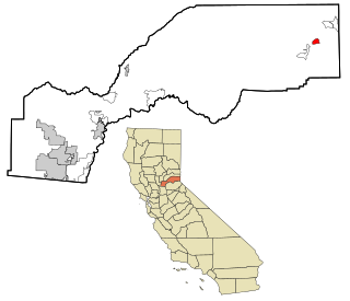
El Dorado County, officially the County of El Dorado, is a county located in the U.S. state of California. As of the 2020 census, the population was 191,185. The county seat is Placerville. The county is part of the Sacramento-Roseville-Arden-Arcade, CA Metropolitan Statistical Area. It is located entirely in the Sierra Nevada, from the historic Gold Country in the western foothills to the High Sierra in the east. El Dorado County's population has grown as Greater Sacramento has expanded into the region. Where the county line crosses US 50 at Clarksville, the distance to Sacramento is 15 miles (24 km). In the county's high altitude eastern end at Lake Tahoe, environmental awareness and environmental protection initiatives have grown along with the population since the 1960 Winter Olympics, hosted at the former Squaw Valley Ski Resort in neighboring Placer County.

<span class="mw-page-title-main">San Andreas, California</span> Census-designated place in California, United States

San Andreas is an unincorporated census-designated place and the county seat of Calaveras County, California. The population was 2,783 at the 2010 census, up from 2,615 at the 2000 census. Like most towns in the region, it was founded during the California Gold Rush. The town is located on State Route 49 and is registered as California Historical Landmark #252.

<span class="mw-page-title-main">Cameron Park, California</span> CDP in California, United States

Cameron Park is a census-designated place (CDP) in El Dorado County, California, United States and is part of the Greater Sacramento Area. The population was 19,171 in the 2020 census, up from 18,228 in 2010. Cameron Park is a community located in the Northern California Gold Country of the Sierra Nevada foothills, approximately 30 miles (50 km) east of Sacramento and 70 miles (110 km) west of South Lake Tahoe.

<span class="mw-page-title-main">El Dorado Hills, California</span> Census-designated place in California, United States

El Dorado Hills is an unincorporated town and census-designated place in El Dorado County, California. Located in the Greater Sacramento region of Northern California, it had a population of 50,547 at the 2020 census, up from 42,108 at the 2010 census.

<span class="mw-page-title-main">Yokuts Valley, California</span> Community in Fresno County, California

Yokuts Valley, formerly Squaw Valley, is a unincorporated community located in Fresno County, California, at the foothills of the Sierra Nevada on State Route 180 just below Kings Canyon National Park.

<span class="mw-page-title-main">Aromas, California</span> Census-designated place in California, United States

Aromas is an unincorporated community and census-designated place (CDP) in Monterey County and San Benito County, California, United States. The population was 2,708 at the 2020 census.

<span class="mw-page-title-main">Dollar Point, California</span> Census-designated place in California, United States

Dollar Point is a census-designated place (CDP) in Placer County, California, United States, along the northwest shore of Lake Tahoe. It is part of the Sacramento–Arden-Arcade–Roseville Metropolitan Statistical Area. The population was 1,215 at the 2010 census down from 1,539 at the 2000 census.

<span class="mw-page-title-main">Kings Beach, California</span> Census-designated place in California, United States

Kings Beach is a census-designated place (CDP) in Placer County, California, United States, on the north shore of Lake Tahoe. The population was 3,563 at the 2020 census.

<span class="mw-page-title-main">Sunnyside–Tahoe City, California</span> Census-designated place in California, United States

Sunnyside–Tahoe City is a census-designated place (CDP) in Placer County, California, located on the northwest shore of Lake Tahoe. The population was 1,557 at the 2010 census, down from 1,761 at the 2000 census, and a total area of 3.4 sq mi (8.8 km2), all of it land. It includes the two communities, Sunnyside, and Tahoe City.

<span class="mw-page-title-main">Tahoe Vista, California</span> Census-designated place in California, United States

Tahoe Vista is a census-designated place located on the north shore of Lake Tahoe in Placer County, California. It is part of the Sacramento–Arden-Arcade–Roseville Metropolitan Statistical Area. The population was 1,433 at the 2010 census, down from 1,668 at the 2000 census.

<span class="mw-page-title-main">South Lake Tahoe, California</span> City in California, United States

South Lake Tahoe is the most populous incorporated city in El Dorado County, California, United States, in the Sierra Nevada mountains. The city's population was 21,330 at the 2020 census, down from 21,403 at the 2010 census. The city, along the southern edge of Lake Tahoe, extends about 5 miles (8 km) west-southwest along U.S. Route 50, also known as Lake Tahoe Boulevard. The east end of the city, on the California–Nevada state line right next to the town of Stateline, Nevada, is mainly geared towards tourism, restaurants, hotels, and Heavenly Mountain Resort with the Nevada casinos just across the state line in Stateline. The western end of town is mainly residential, and clusters around "The Y", the intersection of US 50, State Route 89, and the continuation of Lake Tahoe Boulevard after it loses its federal highway designation.

<span class="mw-page-title-main">Coloma, California</span> Census-designated place in California, United States

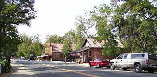
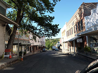
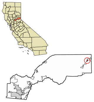
Coloma is a census-designated place in El Dorado County, California, US. It is approximately 36 miles (58 km) northeast of Sacramento, California. Coloma is most noted for being the site where James W. Marshall found gold in the Sierra Nevada foothills, at Sutter's Mill on January 24, 1848, leading to the California Gold Rush. Coloma's population is 529.

<span class="mw-page-title-main">Camino, California</span> Census-designated place in California, United States

Camino is a census-designated place in El Dorado County, California, and, per the 2010 census, has a population of 1,750. According to the USGS, it lies at an elevation of 3133 feet, but the elevation actually ranges between 3,000 and 3,500 feet. Being well more than half a mile above sea level, it snows several times per year in the community. Nearby cities and towns include Pollock Pines, Placerville, Diamond Springs, El Dorado, Grizzly Flats, Somerset, Coloma, Garden Valley, Cameron Park, Shingle Springs, and Lotus.

<span class="mw-page-title-main">Carnelian Bay, California</span> Census-designated place in California, United States

Carnelian Bay is an unincorporated community on the shore of Lake Tahoe in Placer County, California, United States. The Cornelian Bay post office operated from 1883 to 1887 and from 1891 to 1893. The Carnelian Bay post office opened in 1908.

<span class="mw-page-title-main">Camptonville, California</span> Census-designated place in California, United States

Camptonville is a small town and census-designated place (CDP) located in northeastern Yuba County, California. The town is located 36 miles (58 km) northeast of Marysville, off Highway 49 between Downieville and Nevada City. It is located on a ridge between the North Fork and Middle Fork of the Yuba River, not far from New Bullards Bar Dam Reservoir. Camptonville lies at an elevation of 2825 feet. The population was 158 at the 2010 census.

<span class="mw-page-title-main">Oak Hills, San Bernardino County, California</span> Census-designated place in California, United States

Oak Hills is a census-designated place in the Victor Valley of the Mojave Desert, within San Bernardino County, California.

<span class="mw-page-title-main">Butte Valley, California</span> Unincorporated community in California, United States

Butte Valley is an unincorporated community and census-designated place (CDP) named for a former settlement in Butte County, California, United States. It is located 5.5 miles (8.9 km) southeast of Chico. A post office operated at Butte Valley from 1861 to 1871, when it was re-located to Durham. Butte Valley sits at an elevation of 351 feet. The 2010 United States census reported Butte Valley's population is 899.

Cold Springs is a census-designated place in El Dorado County, California. It is located 4 miles (6.4 km) west of Placerville, at an elevation of 1207 feet. It has a population of 446.

Reliez Valley is a census-designated place in Contra Costa County, California. Reliez Valley sits at an elevation of 299 feet (91 m). The 2010 United States census reported Reliez Valley's population was 3,101.

<span class="mw-page-title-main">Hartland, California</span> Census-designated place in California, United States

Hartland is a census-designated place (CDP) in Tulare County, California, United States. Hartland sits at an elevation of 4,475 feet (1,364 m). The 2010 United States census reported Hartland's population was 30.

References

  1. 1 2 3 U.S. Geological Survey Geographic Names Information System: Tahoma, California
  2. "US Census Bureau". www.census.gov. Retrieved August 7, 2024.
  3. 1 2 3 Durham, David L. (1998). California's Geographic Names: A Gazetteer of Historic and Modern Names of the State. Clovis, Calif.: Word Dancer Press. p. 566. ISBN   1-884995-14-4.
  4. ZIP Code Lookup
  5. Gudde, Erwin G. (1998). California place names : the origin and etymology of current geographical names (4th ed., rev. and enl. ed.). Berkeley: University of California Press. p.  384. ISBN   0520213165.
  6. Squaw Valley Organizing Committee (1960). VIII Olympic Winter Games Squaw Valley, California 1960 Final Report (PDF). Squaw Valley: California Olympic Commission. p. 115. Retrieved June 20, 2012.
  7. "U.S. Climate Normals Quick Access – Station: Tahoma, CA". National Oceanic and Atmospheric Administration. Retrieved March 8, 2023.
  8. "xmACIS2". National Oceanic and Atmospheric Administration. Retrieved March 8, 2023.
  9. "Decennial Census by Decade". United States Census Bureau .
  10. 1 2 "2010 Census of Population - Population and Housing Unit Counts - California" (PDF). United States Census Bureau .
  11. "2010 Census Interactive Population Search: CA - Tahoma CDP". U.S. Census Bureau. Archived from the original on July 15, 2014. Retrieved July 12, 2014.