
Butte County is a county located in the northern part of the U.S. state of California. In the 2020 census, its population was 211,632. The county seat is Oroville.

Plumas County is a county in the Sierra Nevada of the U.S. state of California. As of the 2020 census, the population was 19,790. The county seat is Quincy, and the only incorporated city is Portola. The largest community in the county is East Quincy. The county was named for the Spanish Río de las Plumas, which flows through it. The county itself is also the namesake of a native moth species, Hadena plumasata.

Northern California is a geographic and cultural region that generally comprises the northern portion of the U.S. state of California. Spanning the state's northernmost 48 counties, its main population centers include the San Francisco Bay Area, the Greater Sacramento area, the Redding, California, area south of the Cascade Range, and the Metropolitan Fresno area. Northern California also contains redwood forests, along with most of the Sierra Nevada, including Yosemite Valley and part of Lake Tahoe, Mount Shasta, and most of the Central Valley, one of the world's most productive agricultural regions.

The Gold Country is a historic region in the northern portion of the U.S. state of California, that is primarily on the western slope of the Sierra Nevada. It is famed for the mineral deposits and gold mines that attracted waves of immigrants, known as the 49ers, during the 1849 California Gold Rush.

The Shasta Cascade region of California is located in the northeastern and north-central sections of the state bordering Oregon and Nevada, including far northern parts of the Central Valley and the Sierra Nevada mountain range.

The Sacramento Valley is the area of the Central Valley of the U.S. state of California that lies north of the Sacramento–San Joaquin River Delta and is drained by the Sacramento River. It encompasses all or parts of ten Northern California counties. Although many areas of the Sacramento Valley are rural, it contains several urban areas, including the state capital, Sacramento. Since 2010, statewide droughts in California have further strained both the Sacramento Valley's and the Sacramento metropolitan region's water security.

The Feather River is the principal tributary of the Sacramento River, in the Sacramento Valley of Northern California. The river's main stem is about 73 miles (117 km) long. Its length to its most distant headwater tributary is just over 210 miles (340 km). The main stem Feather River begins in Lake Oroville, where its four long tributary forks join—the South Fork, Middle Fork, North Fork, and West Branch Feather Rivers. These and other tributaries drain part of the northern Sierra Nevada, and the extreme southern Cascades, as well as a small portion of the Sacramento Valley. The total drainage basin is about 6,200 square miles (16,000 km2), with approximately 3,604 square miles (9,330 km2) above Lake Oroville.

State Route 89 is a state highway in the U.S. state of California that travels in the north–south direction, serving as a major thoroughfare for many mountain communities in the Sierra Nevada and the Cascade Range. It starts from U.S. Route 395 near Topaz Lake, winding its way up to the 8,314-foot (2,534 m) Monitor Pass, down to the Carson River, and up again over the 7,740-foot (2,359 m) Luther Pass. From that point on, the route generally loses elevation on its way past Lake Tahoe, through Tahoe and Plumas National Forests until Lake Almanor. For roughly nine miles the route is then a part of State Route 36. The route then ascends to the 5,753-foot (1,754 m) Morgan Summit. After it enters Lassen Volcanic National Park it continues to gain elevation until it reaches its highest point in an unnamed pass in the middle of Lassen Peak and Bumpass Mountain. The road then descends and heads northwest, finally terminating at Interstate 5 at the foot of Mount Shasta at around 3,600 feet (1,100 m).
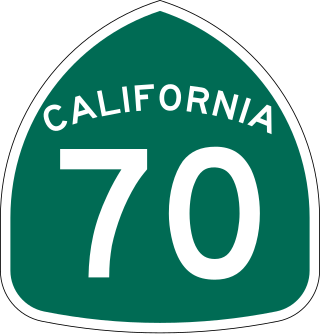
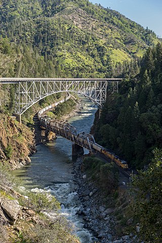
State Route 70 is a state highway in the U.S. state of California, connecting SR 99 north of Sacramento with U.S. Route 395 near Beckwourth Pass via the Feather River Canyon. Through the Feather River Canyon, from SR 149 to US 395, SR 70 is the Feather River Scenic Byway, a Forest Service Byway that parallels the ex-Western Pacific Railroad's Feather River Route.

Area codes 209 and 350 are telephone area codes in the North American Numbering Plan (NANP) for the U.S. state of California. Their service area includes Stockton, Modesto, Turlock, Merced, Winton, Atwater, Livingston, Manteca, Ripon, Tracy, Lodi, Galt, Sonora, Los Banos, San Andreas, Mariposa, and Yosemite, the northern San Joaquin Valley, and the Sierra Foothills.

Area codes 707 and 369 are telephone area codes in the North American Numbering Plan (NANP) for the northwestern part of the U.S. state of California. The area codes serve part of the northern San Francisco Bay Area, as well as the North Coast. Major cities in the area codes include Napa, Sebastopol, Vallejo, Benicia, Fairfield, Santa Rosa, Windsor, Healdsburg, Rohnert Park, Petaluma, Fort Bragg, Rio Vista, Crescent City, Eureka, Clearlake, Vacaville, Dixon, and Ukiah. 707 was created by a split of area code 415 on March 1, 1959. Area code 369 was added to the numbering plan area (NPA) on February 1, 2023, to form an overlay numbering plan in the service area.
California's 1st congressional district is a U.S. congressional district in California. Doug LaMalfa, a Republican, has represented the district since January 2013. Currently, it encompasses the northeastern part of the state. Since the 2022 election, it includes the counties of Butte, Colusa, Glenn, Lassen, Modoc, Shasta, Siskiyou, Sutter, and Tehama, and most of Yuba County. The largest cities in the district are Chico, Redding, and Yuba City.
California's 3rd congressional district is a U.S. congressional district in California. It includes the northern Sierra Nevada and northeastern suburbs of Sacramento, stretching south to Death Valley. It encompasses Alpine, Inyo, Mono, Nevada, Placer, Plumas, and Sierra counties, as well as parts of El Dorado, Sacramento, and Yuba counties. It includes the Sacramento suburbs of Roseville, Folsom, Orangevale, Rocklin, and Lincoln, and the mountain towns of Quincy, South Lake Tahoe, Truckee, Mammoth Lakes, and Bishop. The district is represented by Republican Kevin Kiley.
The Golden Empire Council (GEC-BSA) is a California-based 501(c)(3) nonprofit affiliated with the Boy Scouts of America and its Western Region, Area 4. The council serves a large section of Northern California, primarily the Sacramento Valley and the northern Sierra Nevada. Its boundaries range north to south from Redding to Elk Grove and west to east from Vacaville to Pollock Pines and include 16 Northern California Counties. Its council headquarters and service center is located in Sacramento. The council also operates two Scout Shops selling BSA merchandise; located in Sacramento and Chico.
The North Fork Feather River is a watercourse of the northern Sierra Nevada and southern Cascades in the U.S. state of California. It flows generally southwards from its headwaters near Lassen Peak to Lake Oroville, a reservoir formed by Oroville Dam in the foothills of the Sierra, where it runs into the Feather River. The river drains about 2,100 square miles (5,400 km2) of the western slope of the Sierras. By discharge, it is the largest tributary of the Feather.
The Feather Headwaters is the watershed of the Feather River above Lake Oroville, totaling 3,450 sq mi (8,900 km2). Subdivided into 3 watersheds, the North Fork Feather Watershed is 1,090 sq mi (2,800 km2)—including the West Branch drainage of about 282.5 sq mi (732 km2), the East Branch North Fork Feather Watershed is 1,010 sq mi (2,600 km2), and the Middle Fork Feather Watershed is 1,350 sq mi (3,500 km2)—including the South Fork drainage of about 132 sq mi (340 km2). Headwaters drainage is impaired by the Palermo Canal at Oroville Dam, the Hendricks Canal at the West Branch Feather River, and the Miners Ranch Canal at the South Fork's Ponderosa Reservoir. Additionally, the Pacific Gas and Electric Company releases Upper Feather water into the Hyatt Generating-Pumping Plant for hydroelectric generation during daily peak demand.

The Upper North Fork Feather River Project is a hydroelectric scheme in the Sierra Nevada of California, within Lassen and Plumas Counties. The project consists of three dams, five power plants, and multiple conduits and tunnels in the headwaters of the North Fork Feather River, a major tributary of the Feather—Sacramento River systems. The total installed capacity is 362.3 megawatts (MW), producing an annual average of 1,171.9 gigawatt hours (GWh). The project is also contracted for the delivery of irrigation water between March 31 and October 31 of each year. The project is owned and operated by Pacific Gas and Electric Company.
