Doyle, Lassen County, California

Last updated • 3 min readFrom Wikipedia, The Free Encyclopedia

Doyle
Lassen County California Incorporated and Unincorporated areas Doyle Highlighted 0619878.svg
Location in Lassen County and the state of California
Usa edcp relief location map.png
Red pog.svg
Doyle
Location in the United States
Coordinates: 40°01′41″N120°06′14″W / 40.02806°N 120.10389°W / 40.02806; -120.10389
Country Flag of the United States (23px).png  United States
State Flag of California.svg  California
County Lassen County
Area
[1]
  Total
6.108 sq mi (15.819 km2)
  Land6.107 sq mi (15.817 km2)
  Water0.001 sq mi (0.002 km2)  0.01%
Elevation
[2]
4,275 ft (1,303 m)
Population
 (2020)
  Total
536
  Density88/sq mi (34/km2)
Time zone UTC−08:00 (PST)
  Summer (DST) UTC−07:00 (PDT)
ZIP Code
96109
Area code 530
GNIS feature IDs222577; 2583001
U.S. Geological Survey Geographic Names Information System: Doyle, Lassen County, California; U.S. Geological Survey Geographic Names Information System: Doyle, Lassen County, California

Doyle is a rural small town in Lassen County, California. [2] It is located 40 miles (64 km) southeast of Susanville, [3] at an elevation of 4275 feet (1303 m). [2] It is located 45 miles (72 km) northwest of Reno, Nevada. The ZIP Code is 96109. The community is inside area code 530. It is located within a census-designated place named after the town, [4] while the population of the town itself was not given. Its population is 536 as of the 2020 census, down from 678 from the 2010 census.

Contents

History

Oscar Doyle settled at the site in the 1870s and donated land for the town. [3] The first post office at Doyle opened in 1908. [3] The town lost 33 homes in the Beckwourth Complex Fire in July 2021. [5]

Geography

According to the United States Census Bureau, the CDP has a total area of 6.1 square miles (15.8 km2), over 99% of which is land.[ citation needed ]

Climate

Doyle has a warm-summer Mediterranean climate (Csb), according to the Köppen climate classification system. Due to its relative aridity, it nearly qualifies as having a steppe climate (BSk).[ citation needed ]

Climate data for Doyle (1923-2012)
MonthJanFebMarAprMayJunJulAugSepOctNovDecYear
Record high °F (°C)66
(19)
68
(20)
80
(27)
87
(31)
98
(37)
107
(42)
111
(44)
107
(42)
105
(41)
90
(32)
76
(24)
69
(21)
111
(44)
Mean daily maximum °F (°C)41.7
(5.4)
47.6
(8.7)
56.3
(13.5)
65.1
(18.4)
74
(23)
82.7
(28.2)
93.4
(34.1)
91.6
(33.1)
82.4
(28.0)
69.7
(20.9)
53.9
(12.2)
43.5
(6.4)
66.8
(19.3)
Mean daily minimum °F (°C)20.1
(−6.6)
24.3
(−4.3)
28
(−2)
32.6
(0.3)
38.3
(3.5)
43.4
(6.3)
48.8
(9.3)
46.4
(8.0)
41.1
(5.1)
33.8
(1.0)
26.1
(−3.3)
21.4
(−5.9)
33.7
(0.9)
Record low °F (°C)−31
(−35)
−24
(−31)
2
(−17)
7
(−14)
18
(−8)
12
(−11)
28
(−2)
29
(−2)
19
(−7)
8
(−13)
−10
(−23)
−25
(−32)
−31
(−35)
Average precipitation inches (mm)1.8
(46)
1.39
(35)
1.15
(29)
0.62
(16)
0.62
(16)
0.53
(13)
0.25
(6.4)
0.22
(5.6)
0.36
(9.1)
0.76
(19)
1.25
(32)
1.73
(44)
10.69
(272)
Average snowfall inches (cm)5.6
(14)
3.7
(9.4)
3.5
(8.9)
1.8
(4.6)
0.6
(1.5)
0
(0)
0
(0)
0
(0)
0.1
(0.25)
0.2
(0.51)
2
(5.1)
5
(13)
22.6
(57)
Average precipitation days66644311235647
Source: WRCC [6]

Demographics

The 2010 United States Census [7] reported that Doyle had a population of 678. The population density was 111.0 inhabitants per square mile (42.9/km2). The racial makeup of Doyle was 583 (86.0%) White, 14 (2.1%) African American, 37 (5.5%) Native American, 3 (0.4%) Asian, 2 (0.3%) Pacific Islander, 12 (1.8%) from other races, and 27 (4.0%) from two or more races. Hispanic or Latino of any race were 55 persons (8.1%).

The Census reported that 678 people (100% of the population) lived in households, 0 (0%) lived in non-institutionalized group quarters, and 0 (0%) were institutionalized.

There were 261 households, out of which 81 (31.0%) had children under the age of 18 living in them, 125 (47.9%) were opposite-sex married couples living together, 36 (13.8%) had a female householder with no husband present, 20 (7.7%) had a male householder with no wife present. There were 28 (10.7%) unmarried opposite-sex partnerships, and 1 (0.4%) same-sex married couples or partnerships; 68 households (26.1%) were made up of individuals, and 20 (7.7%) had someone living alone who was 65 years of age or older. The average household size was 2.60. There were 181 families (69.3% of all households); the average family size was 3.02.

The population age range was spread out, with 157 people (23.2%) under the age of 18, 49 people (7.2%) aged 18 to 24, 159 people (23.5%) aged 25 to 44, 227 people (33.5%) aged 45 to 64, and 86 people (12.7%) who were 65 years of age or older. The median age was 41.6 years. For every 100 females, there were 104.2 males. For every 100 females age 18 and over, there were 101.2 males.

There were 318 housing units at an average density of 52.1 per square mile (20.1/km2), of which 178 (68.2%) were owner-occupied, and 83 (31.8%) were occupied by renters. The homeowner vacancy rate was 6.8%; the rental vacancy rate was 10.8%. 448 people (66.1% of the population) lived in owner-occupied housing units and 230 people (33.9%) lived in rental housing units.

Politics

In the state legislature, Doyle is in the 1st Senate District , represented by Republican Megan Dahle, [8] and the 1st Assembly District , represented by Republican Heather Hadwick. [9]

Federally, Doyle is in California's 1st congressional district , represented by Republican Doug LaMalfa. [10]

Related Research Articles

<span class="mw-page-title-main">Plumas County, California</span> County in California, United States

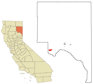
Plumas County is a county located in the Sierra Nevada of the U.S. state of California. As of the 2020 census, the population was 19,790. The county seat is Quincy, and the only incorporated city is Portola. The largest community in the county is East Quincy. The county was named for the Spanish Río de las Plumas, which flows through it. The county itself is also the namesake of a native moth species, Hadena plumasata.

<span class="mw-page-title-main">Susanville, California</span> City in California, United States

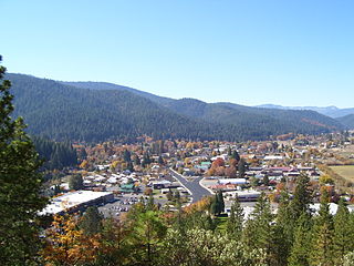
Susanville is the only incorporated city in Lassen County, California, United States, of which it is also the county seat. Susanville is located on the Susan River in the southern part of the county, at an elevation of 4,186 feet (1,276 m). Its population is 16,728 as of the 2020 census, down from 17,947 from the 2010 census. The Susanville urban area contains 8,995 people and 4,233 households.

<span class="mw-page-title-main">Westwood, California</span> Census-designated place in California, United States

Westwood is a census-designated place (CDP) in Lassen County, California, United States. Westwood is located 20 miles (32 km) west-southwest of Susanville, at an elevation of 5,128 feet. Its population is 1,541 as of the 2020 census, down from 1,647 from the 2010 census..

<span class="mw-page-title-main">Beckwourth, California</span> Census-designated place in California, United States

Beckwourth is a census-designated place (CDP) in Plumas County, California, United States. Beckwourth is located on the Middle Fork Feather River 5 miles (8.0 km) east of Portola. The population was 432 at the 2010 census, up from 342 at the 2000 census.

<span class="mw-page-title-main">Canyondam, California</span> Census-designated place in California, United States

Canyondam is a census-designated place (CDP) in Plumas County, United States. Canyondam is located near the dam that forms Lake Almanor, 6.25 miles (10.1 km) east-southeast of Almanor. The population was 31 as of the 2010 census, down from 37 as of the 2000 census. On August 6, 2021, the community was destroyed in the Dixie Fire.

<span class="mw-page-title-main">Quincy, California</span> Census-designated place in California, United States

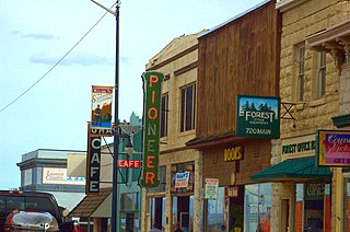
Quincy is a census-designated place and the county seat of Plumas County, California. The population was 1,630 during the 2020 Census, down from 1,728 during the 2010 Census, and 1,879 during the 2000 Census.

<span class="mw-page-title-main">Strathmore, California</span> Census-designated place in California, United States

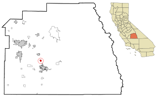
Strathmore is a census-designated place (CDP) in Tulare County, California, United States. The population was 2,819 at the 2010 census, up from 2,584 at the 2000 census.

<span class="mw-page-title-main">Adin, California</span> Census-designated place in California, United States

Adin is a census-designated place in Modoc County, California. It is located 29 miles (47 km) southwest of Alturas, at an elevation of 4,203 feet (1,281 m). Its population is 205 as of the 2020 census, down from 272 from the 2010 census.

<span class="mw-page-title-main">Herlong, California</span> Census-designated place in California, United States

Herlong is a census-designated place in Lassen County, California. Herlong is located at the extreme eastern edge of the Sierra Nevada Mountain Range in the southeastern region of Honey Lake Valley, 8 miles (13 km) north of Doyle, at an elevation of 4,114 feet (1,254 m). Its population is 237 as of the 2020 census, down from 298 from the 2010 census. Herlong is located in southern Lassen County near the southeast edge of Honey Lake, about 70 miles (110 km) north of Reno, Nevada, and about 45 miles (72 km) south of Susanville, the county seat. The community is accessible to U.S. Route 395 via Lassen County Route A25 or Lassen County Route A26.

<span class="mw-page-title-main">Janesville, California</span> Census-designated place in California, United States

Janesville is a sparsely populated census-designated place in Lassen County, California. It is located 11 miles (18 km) southeast of Susanville, at an elevation of 4239 feet. Janesville is located on the eastern slopes of the Sierra Nevada Mountain range. Its population is 2,461 as of the 2020 census, up from 1,408 from the 2010 census.

<span class="mw-page-title-main">Hat Creek, California</span> Census designated place in California, United States

Hat Creek is a census designated place (CDP) in Shasta County, California. Hat Creek is situated at an elevation of 3,422 feet (1,043 m). Its population is 266 as of the 2020 census, down from 309 from the 2010 census.

<span class="mw-page-title-main">Old Station, California</span> Census-designated place in California, United States

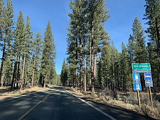
Old Station is a census-designated place (CDP) in Shasta County, California. It is located 13 miles (21 km) north of Lassen Volcanic National Park, directly between Redding and Susanville. The ZIP code in Old Station is 96071 and the area code 530. Old Station sits at an elevation of 4,386 feet (1,337 m). Its population is 64 as of the 2020 census, up from 51 from the 2010 census.

Clear Creek is a census-designated place (CDP) in Lassen County, California. It is located 2.5 miles (4 km) west-southwest of Westwood, at an elevation of 4970 feet. Its population is 175 as of the 2020 census, up from 169 from the 2010 census.

<span class="mw-page-title-main">Johnstonville, California</span> Census-designated place in California, United States

Johnstonville is a census-designated place in Lassen County, California. It is located 4.5 miles (7 km) east-southeast of Susanville, at an elevation of 4131 feet. Its population is 973 as of the 2020 census, down from 1,024 from the 2010 census.

<span class="mw-page-title-main">Litchfield, California</span> Census-designated place in California, United States

Litchfield is a census-designated place in Lassen County, California. It is located 15 miles (24 km) east of Susanville, at an elevation of 4,065 feet (1,239 m). Its population is 160 as of the 2020 census, down from 195 from the 2010 census.

<span class="mw-page-title-main">Milford, California</span> Census-designated place in California, United States

Milford is a census-designated place in Lassen County, California. It is located on Mill Creek 15 miles (24 km) south of Litchfield, at an elevation of 4222 feet. Its population is 147 as of the 2020 census, down from 167 from the 2010 census.

Nubieber is a census-designated place in Lassen County, California. It is located at the common terminus of the Western Pacific Railroad and the Great Northern Railway Bieber Line 3 miles (4.8 km) southwest of Bieber, at an elevation of 4121 feet. Its population is 19 as of the 2020 census, down from 50 from the 2010 census.

Patton Village is a census-designated place in Lassen County, California. It lies at an elevation of 4111 feet. Its population is 632 as of the 2020 census, down from 702 from the 2010 census.

Spaulding is a census-designated place in Lassen County, California. It is located on the west side of Eagle Lake, 2.1 miles (3.4 km) east-northeast of Whaleback Mountain and 3 miles (4.8 km) northeast of Eagle Lodge, at an elevation of 5138 feet. Its population is 206 as of the 2020 census, up from 178 from the 2010 census.

<span class="mw-page-title-main">Sierraville, California</span> Census-designated place in California, United States

Sierraville is a census-designated place in Sierra County, California, United States. It is at the southern end of the huge Sierra Valley which is used primarily as pasture and is also at the junction of California State Route 49 and California State Route 89 southwest of Loyalton. Sierraville has a post office with ZIP code 96126. The post office opened under the name Sierra Valley in 1862 and became known as the Sierraville post office in 1899. The population was 200 as of the 2010 census.

References

  1. U.S. Census Archived 2012-07-02 at the Wayback Machine
  2. 1 2 3 U.S. Geological Survey Geographic Names Information System: Doyle, Lassen County, California
  3. 1 2 3 Durham, David L. (1998). California's Geographic Names: A Gazetteer of Historic and Modern Names of the State. Clovis, Calif.: Word Dancer Press. p. 373. ISBN   1-884995-14-4.
  4. U.S. Geological Survey Geographic Names Information System: Doyle, Lassen County, California
  5. "Beckwourth Complex burns 100K acres; 33 houses destroyed as containment decreases". FOX40. Associated Press. July 15, 2021. Retrieved August 5, 2021.
  6. "DOYLE, CA (042504)". Western Regional Climate Center. Retrieved November 29, 2015.
  7. "2010 Census Interactive Population Search: CA - Doyle CDP". U.S. Census Bureau. Archived from the original on July 15, 2014. Retrieved July 12, 2014.
  8. "Senators". State of California. Retrieved March 10, 2013.
  9. "Members Assembly". State of California. Retrieved March 2, 2013.
  10. "California's 1st Congressional District - Representatives & District Map". Civic Impulse, LLC. Retrieved March 3, 2013.