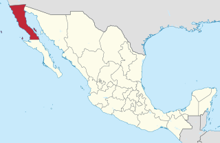
Baja California, officially Estado Libre y Soberano de Baja California, is a state in Mexico. It is the northernmost and westernmost of the 32 federal entities of Mexico. Before becoming a state in 1952, the area was known as the North Territory of Baja California. It has an area of 70,113 km2 (27,071 sq mi) and comprises the northern half of the Baja California Peninsula, north of the 28th parallel, plus oceanic Guadalupe Island. The mainland portion of the state is bordered on the west by the Pacific Ocean; on the east by Sonora, the U.S. state of Arizona, and the Gulf of California; on the north by the U.S. state of California; and on the south by Baja California Sur.

The North American Central Time Zone (CT) is a time zone in parts of Canada, the United States, Mexico, Central America and some Caribbean islands.

The Mountain Time Zone of North America keeps time by subtracting seven hours from Coordinated Universal Time (UTC) when standard time (UTC−07:00) is in effect, and by subtracting six hours during daylight saving time (UTC−06:00). The clock time in this zone is based on the mean solar time at the 105th meridian west of the Greenwich Observatory. In the United States, the exact specification for the location of time zones and the dividing lines between zones is set forth in the Code of Federal Regulations at 49 CFR 71.

The Pacific Time Zone (PT) is a time zone encompassing parts of western Canada, the western United States, and western Mexico. Places in this zone observe standard time by subtracting eight hours from Coordinated Universal Time (UTC−08:00). During daylight saving time, a time offset of UTC−07:00 is used.

The Peninsular Ranges are a group of mountain ranges that stretch 1,500 km (930 mi) from Southern California to the southern tip of the Baja California peninsula; they are part of the North American Pacific Coast Ranges, which run along the Pacific Coast from Alaska to Mexico. Elevations range from 150 to 3,300 m.
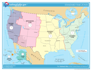
In the United States, time is divided into nine standard time zones covering the states, territories and other US possessions, with most of the country observing daylight saving time (DST) for approximately the spring, summer, and fall months. The time zone boundaries and DST observance are regulated by the Department of Transportation, but no single map of those existed until the agency announced intentions to make one in September 2022. Official and highly precise timekeeping services (clocks) are provided by two federal agencies: the National Institute of Standards and Technology (NIST) ; and the United States Naval Observatory (USNO). The clocks run by these services are kept synchronized with each other as well as with those of other international timekeeping organizations.
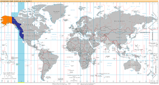
UTC−08:00 is an identifier for a time offset from UTC of −08:00. This time is used:
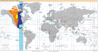
UTC−06:00 is an identifier for a time offset from UTC of −06:00. In North America, it is observed in the Central Time Zone during standard time, and in the Mountain Time Zone during the other eight months. Several Latin American countries and a few other places use it year-round.
Qwest Corporation is a Regional Bell Operating Company owned by Lumen Technologies. It was formerly named U S WEST Communications, Inc. from 1991 to 2000, and also formerly named Mountain States Telephone and Telegraph Company, known as Mountain Bell from 1911 to 1991. It includes the former operations of Malheur Bell, Northwestern Bell and Pacific Northwest Bell as well.
USA Volleyball (USAV) is a non-profit organization which is recognized as the national governing body of volleyball in the United States by the Fédération Internationale de Volleyball (FIVB) and the United States Olympic Committee (USOC). It is headquartered in Colorado Springs, Colorado, and was founded by the YMCA of the USA. The organization is responsible for selecting and supporting US national teams that compete in FIVB-sanctioned international volleyball and beach volleyball competitions such as the Olympic Summer Games. USA Volleyball is also charged with fostering the development of the sport of volleyball within the United States through involvement with its forty Regional Volleyball Associations (RVAs).

Mountain City is a small census-designated place in Elko County, Nevada, United States, within the Mountain City Ranger District of the Humboldt-Toiyabe National Forest. The community, located on State Route 225 approximately 16 miles (26 km) south of the Idaho border, is situated on the Owyhee River at an elevation of approximately 5,620 feet (1,710 m).

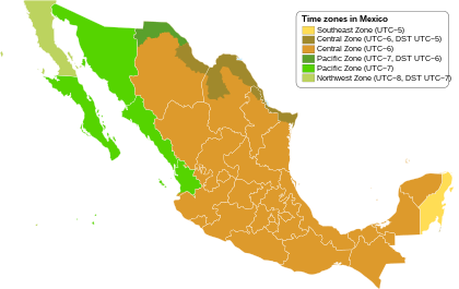
Mexico uses four time zones:

Arizona is a landlocked state situated in the southwestern region of the United States of America. It has a vast and diverse geography famous for its deep canyons, high- and low-elevation deserts, numerous natural rock formations, and volcanic mountain ranges. Arizona shares land borders with Utah to the north, the Mexican state of Sonora to the south, New Mexico to the east, and Nevada to the northwest, as well as water borders with California and the Mexican state of Baja California to the southwest along the Colorado River. Arizona is also one of the Four Corners states and is diagonally adjacent to Colorado.

The Mountain states form one of the nine geographic divisions of the United States that are officially recognized by the United States Census Bureau. It is a subregion of the Western United States.

The chronological order in which countries enter in the new year is determined by the time zone of that particular country or region. The headers display the time and timezone.
Almost all of Nevada is in the Pacific Time Zone. The few exceptions that exist all observe Mountain Time and are close to the borders of Idaho or Utah. Other than these minor exceptions, Nevada is the only non coastal state to be entirely on Pacific Time. Most of Idaho uses Mountain Time, and Arizona is officially on Mountain Time except for the 2/3 of the year when Daylight Saving Time is in effect, which they don't observe.
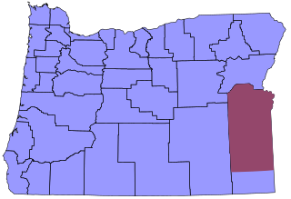
Time in Oregon is divided into two zones, with the vast majority in the Pacific Time Zone. Most of sparsely populated Malheur County, including its largest city, Ontario, and its county seat, Vale, are in the Mountain Time Zone due to their proximity to Boise, Idaho. The time zone division occurs at the southwest corner of township 35 S, range 37 E, continuing east to the state line, then south along the Oregon-Idaho border to the Nevada state line.

Time in Arizona, as in all U.S. states, is regulated by the United States Department of Transportation as well as by state and tribal law.

