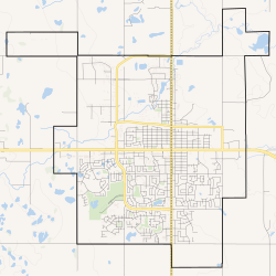
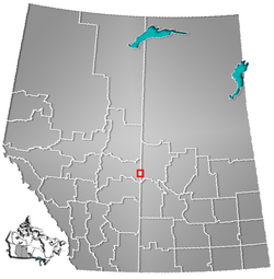
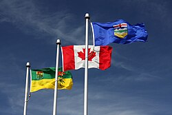
Lloydminster is a city in Canada which has the unusual geographic distinction of straddling the provincial border between Alberta[3] and Saskatchewan.[10][11] The city is incorporated by both provinces as a single city with a single municipal administration.
Intended to be an exclusively British utopian settlement centred on the idea of sobriety, Lloydminster was founded in 1903 by the Barr Colonists, who came directly from the United Kingdom.[12] At a time when the area was still part of the North-West Territories, the town was located astride the Fourth Meridian of the Dominion Land Survey. This meridian was intended to coincide with the 110° west longitude, although the imperfect surveying methods of the time led to the surveyed meridian being placed a few hundred metres (yards) west of this longitude.[13]
The town was named for George Lloyd, an Anglican priest who would become Bishop of Saskatchewan in 1922. Lloyd was a strong opponent of non-British immigration to Canada. During a nearly disastrous immigration journey, which was badly planned and conducted,[14] he distinguished himself with the colonists and replaced the Barr Colony's leader and namesake Isaac Montgomery Barr during the colonists' journey to the eventual townsite.[15]
The town developed rapidly: by 1904, there was a telegraph office as well as a log church; in 1905, the Lloydminster Daily Times started publication and the first train arrived on July 28.[16] Its main north–south street, today named Meridian Avenue (or 50th Avenue), along which stores, businesses and the post office began locating, was situated right on the Fourth Meridian, although the actual road right-of-way was located in Saskatchewan.[citation needed] To comply with temperance principles, alcohol was not available in Lloydminster for the first few years after its founding.[citation needed]
Beginning in 1900, calls for provincial autonomy in Western Canada grew, including from Frederick Haultain and James Hamilton Ross, two members of the Legislative Assembly of the North-West Territories.[17] Haultain and Ross initially proposed that the districts of Alberta, Saskatchewan, Assiniboia, and Athabasca be merged to create one province.[18] However, feeling that such a large province would be too large to administer, Parliament chose to create the two new provinces of Alberta and Saskatchewan in 1905.[18]
When Alberta and Saskatchewan were created, the Fourth Meridian was selected as the border, bisecting the town right along its main street.[19] Lloydminster residents petitioned for the new border to be revised so as to encompass the entire town within Saskatchewan, without success.[citation needed] Lloydminster functioned as two towns with separate municipal administrations until the provincial governments agreed in 1930 to amalgamate the towns into a single town under shared jurisdiction. The provinces, again jointly, reincorporated Lloydminster as a city in 1958.[19]
Commemorating Lloydminster's distinctive bi-provincial status, a monument consisting of four 30-metre (100ft) survey markers was erected in 1994 near the city's downtown core.[20]
The majority of Lloydminster's population lived on the Saskatchewan side until recent[when?] decades; in the 2011 Canadian Census, nearly two-thirds of the city's population lived on the Alberta side. In 2000, the city hall and municipal offices were moved from Saskatchewan to an Alberta location on Meridian Avenue, also known as 50th Avenue, which runs along the Fourth Meridian.[citation needed]
Despite its bi-provincial status, Lloydminster was not exempted from anti-smoking legislation passed by the Legislative Assembly of Saskatchewan. Citizens responded by initiating a referendum against the wishes of the mayor, as permitted in the charter, which resulted in the enactment of a citywide anti-smoking bylaw. The matter became moot when Alberta enacted its own anti-smoking legislation, which was the solution that the mayor and council preferred.[citation needed]
The provincial border runs north to south, falling directly on 50th Avenue (Meridian Avenue) in the centre of Lloydminster. Meridian Avenue north of the Yellowhead Highway (also named 44th Street) remains the main downtown street for stores, offices and businesses, with some also located on the intersecting east–west streets. Addresses east of 50th Avenue are considered to be in Lloydminster, Saskatchewan and addresses west of 50th Avenue are considered to be in Lloydminster, Alberta. The city is bordered by the County of Vermilion River, Alberta, on the west, the Rural Municipality (R.M.) of Britannia No. 502, Saskatchewan, on the northeast and the R.M. of Wilton No. 472, Saskatchewan, on the southeast. The majority of the large retail properties serving the city, including larger stores, gas stations and hotels, are located in its Alberta portion, in particular along the Yellowhead Highway west of Meridian Avenue and along the Alberta side of 50th Avenue south of the Yellowhead Highway.
Lloydminster's distinctive situation is reflected in other legal matters, including its time zone. Most of Saskatchewan does not observe daylight saving time, instead staying on Central Standard Time year-round. However, Alberta mandates daylight saving time. Lloydminster's charter allows the city to follow Alberta's use of daylight saving time on both sides of the provincial border in order to keep all clocks within the city in synchronization. This has the effect of placing Lloydminster and the surrounding area in the Mountain Time Zone along with Alberta. During the summer therefore, the entire city is on UTC−06:00—Mountain Daylight Time, which is the same as the rest of Saskatchewan where the time is defined as Central Standard Time.[21] During the winter, Lloydminster is on Mountain Standard Time with the rest of Alberta, which is UTC−07:00,[22] and is therefore one hour behind the time in the rest of Saskatchewan.
The provincial line divides the city in two aspects related to communications. Telephones on the Saskatchewan side are assigned to area codes 306 and 639, the two area codes assigned to that province, while land lines on the Alberta side have numbers in the 780 and 587 area codes, the two area codes assigned to northern Alberta. Similarly, Saskatchewan addresses have a postal code with a forward sortation area designation (first three characters) of "S9V", and addresses in Alberta have postal codes beginning with "T9V". All postal codes in Canada beginning with the letter "S" are assigned to Saskatchewan, and those beginning with "T" belong to Alberta.
Climate
Lloydminster experiences a humid continental climate (Köppen climate classificationDfb), which approaches a subarctic climate (Köppen Dfc) due to May and September being only marginally above 10°C (50°F). Winters are long, cold and dry, while summers are short, warm and moderately wet. Year-round precipitation is fairly low, with an average of 408mm (16.06in), whilst the dry winters restrict snowfall to 98cm (38.6in).
The coldest temperature ever recorded was −50.0°C (−58.0°F) on 13 January 1911.[23] The highest temperature ever recorded in Lloydminster was 38.1°C (100.6°F) on 12 July 2002.[24] The record high daily minimum was 21.0°C (69.8°F) recorded July 10, 2001.[25] The record highest dew point was 22.4°C (72.3°F) recorded July 28, 1987.[25] The most humid month was July 2012 with an average dew point of 14.1°C (57.4°F).[25] The warmest month was July 2007 with an average mean tempeature of 20.6°C (69.1°F).[25]
In the 2021 Census of Population conducted by Statistics Canada, the Alberta portion of the City of Lloydminster had a population of 19,739 living in 7,636 of its 8,530 total private dwellings, a change of 0.5% from its 2016 population of 19,645. With a land area of 23.98km2 (9.26sqmi), it had a population density of 823.1/km2 (2,131.9/sqmi) in 2021.[54] The Saskatchewan portion of Lloydminster had a population of 11,843 living in 4,443 of its 5,002 total private dwellings, a change of 0.7% from its 2016 population of 11,765. With a land area of 18.06km2 (6.97sqmi), it had a population density of 655.8/km2 (1,698.4/sqmi) in 2016.[7] Overall, the entire City of Lloydminster had a population of 31,582 living in 12,079 of its 13532 total private dwellings, a change of 0.5% from its 2016 population of 31,410. With a land area of 42.04km2 (16.23sqmi), it had a population density of 751.2/km2 (1,945.7/sqmi) in 2016.[6][7]
In the 2016 Census of Population, the Alberta portion of the City of Lloydminster had a population of 19,645 living in 7,444 of its 8,444 total private dwellings, a change of 8.9% from its 2011 population of 18,032. With a land area of 24.04km2 (9.28sqmi), it had a population density of 817.2/km2 (2,116.5/sqmi) in 2016.[53] Meanwhile, the Saskatchewan portion of Lloydminster had a population of 11,765 living in 4,392 of its 4,909 total private dwellings, a change of 20.4% from its 2011 population of 9,772. With a land area of 18.28km2 (7.06sqmi), it had a population density of 643.6/km2 (1,666.9/sqmi) in 2016.[55] Overall, the entire City of Lloydminster had a population of 31,410 living in 11,836 of its 13,353 total private dwellings in the 2016 Census of Population, a change of 13% from its 2011 population of 27,804. With a land area of 42.32km2 (16.34sqmi), it had a population density of 742.2/km2 (1,922.3/sqmi) in 2016.[53][55]
The City of Lloydminster's 2015 municipal census counted a population of 31,377,[56] a change of −0.3% from its 2013 municipal census population of 31,483.[9] Of the 31,377 residents, 19,740 (63%) lived on the Alberta side and 11,637 (37%) lived on the Saskatchewan side.[9]
There are substantial demographic differences between the populations on each side of the border, with the population on the Saskatchewan side being substantially younger; the median age on the Saskatchewan side is 26.6,[57] nearly seven years less than the median age of 33.2 on the Alberta side. Even when combining the median ages for both sides of the city, Lloydminster has the youngest median age in all of Canada.[58][59] Also, the specific age group of 20–24 is much more concentrated on the Saskatchewan side. The two sides of the city have virtually identical numbers of people in that age group (1,220 in Saskatchewan,[57] 1,230 in Alberta[58]) even though the total population on the Alberta side is nearly twice that of the Saskatchewan side. This situation has been attributed in part to differential car insurance rates for drivers; because Saskatchewan has a public auto insurance system while Alberta relies on conventional private insurance, young drivers with the highest insurance rates can save thousands of dollars by living in Saskatchewan rather than Alberta.[60]
About 94% of residents identified English as their first language. More than 1.4% of the population identified French as their first language, while 0.8% identified German, 0.7% identified Ukrainian, and 0.5% identified Cree as their first language learned. The next most common languages were Chinese and Spanish at about 0.3% each.[61]
Ethnicity
More than 8% of residents identified themselves as aboriginal at the time of the 2006 census.[62]
Panethnic groups in the City of Lloydminster (2001−2021)
Note: Totals greater than 100% due to multiple origin responses
Religion
More than 78% of residents identified as Christian at the time of the 2001 census, while over 18% indicated that they had no religious affiliation. For specific denominations Statistics Canada found that 31% of residents identified as Roman Catholic, and 44% Protestants of which, 18% identified with the United Church of Canada, more than 7% identified as Anglican, about 5% identified as Lutheran, almost 3% identified as Pentecostal, about 2% identified as Baptists, and just over 1% of the population identified as Eastern Orthodox.[73]
Economy
Oil and Gas plaque at the Barr Colony Heritage Cultural Centre
The local economy is driven primarily by the petroleum industry. Agriculture remains an important economic activity. The Husky Lloydminster Refinery is also located in the community. An issue in business is the sales tax. The only sales tax applicable in Alberta is the federal Goods and Services Tax (GST). Saskatchewan has, in addition to GST, a provincial sales tax (PST). To ensure that business will not float away from the Saskatchewan side in favour of lower prices in Alberta, PST does not apply in the Saskatchewan side of the city[74] with the exception of hotels, vehicle registration and utility services.
Government
Lloydminster is governed by a seven-member city council, consisting of a mayor and six city councillors. The city follows the Saskatchewan schedule when voting in municipal elections.[75]
Lloydminster's bi-provincial status has resulted in special provisions regarding provincial taxation within the city limits. The Saskatchewan side of the city is exempt from that province's sales tax, preventing businesses located there from being placed at a disadvantage relative to businesses in Alberta, which has no provincial sales tax.[74] There is no exemption for provincial income tax, which is based solely on the taxpayer's province of residence. Other differences surrounding interprovincial costs are reflected within the treatment of automobile insurance, and housing taxes. For example, a driver under age 25 who lives on the Alberta side will pay approximately 2-3 times the average amount required of a Saskatchewan driver of the same age.[77]
In 2013, an independent report found that Lloydminster was underserved by health care services in comparison to similar catchment areas in Alberta. In 2007, Lloydminster was deemed to have outgrown the capacity of its hospital; calls for more operating rooms, acute care beds, and a dedicated MRI unit did not come to fruition, resulting in patients sometimes having to travel to larger cities such as Saskatoon for operations.[78] Due to health data privacy laws in both provinces, the Lloydminster Hospital does not have direct access to AHS patient records, which have led to Alberta-based patients sometimes bringing their own paper records or receiving diagnostic tests a second time.[79]
The city's contracts with WPD to provide ambulance service in Lloydminster have faced criticism over unsatisfactory performance, with some patients having had to wait up to 40 minutes for help to arrive;[80] in August 2021, AHS pulled out of the contract and signed with a different provider, but WPD invoked an arbitration clause in Saskatchewan law that has prevented the SHA from immediately exiting the contract.[78][81]
Transportation
The city is served by Lloydminster Airport. The Yellowhead Highway (Alberta Highway 16 and Saskatchewan Highway 16) passes through the city from west to east, and Highway 17 (which is considered part of both Alberta's and Saskatchewan's highway system and is maintained by both provinces) travels along the provincial border from south to north. There is no local public transport serving the city.[82]
Education
Elementary and secondary schools on both sides of the border all use Saskatchewan's curriculum.[83] Lloydminster provides public and catholic education up to grade 12 as well as post-secondary education through Lakeland College, offering one and two year certificate and diploma programs.[84]
Lloydminster was served by two broadcast television stations, operated as part of a twinstick operation owned by Stingray Radio. Both stations ceased broadcasting on May 13, 2025.[85]
↑"Lloydminster SK". Environment and Climate Change Canada. October 31, 2011. Retrieved May 1, 2016.
↑"Lloydminster AB". Environment and Climate Change Canada. October 31, 2011. Retrieved May 1, 2016.
↑"Lloydminster North". Environment and Climate Change Canada. October 31, 2011. Retrieved May 1, 2016.
↑"Lloydminster 12E". Environment and Climate Change Canada. October 31, 2011. Retrieved May 1, 2016.
↑"Lloydminster AB". List of charts for Lloydminster AB. weatherstats.ca. February 6, 2026. Retrieved February 6, 2026.
↑"Table IX: Population of cities, towns and incorporated villages in 1906 and 1901 as classed in 1906". Census of the Northwest Provinces, 1906. Vol.Sessional Paper No. 17a. Ottawa: Government of Canada. 1907. p.100.
↑"Table I: Area and Population of Canada by Provinces, Districts and Subdistricts in 1911 and Population in 1901". Census of Canada, 1911. Vol.I. Ottawa: Government of Canada. 1912. pp.2–39.
↑"Table I: Population of Manitoba, Saskatchewan, and Alberta by Districts, Townships, Cities, Towns, and Incorporated Villages in 1916, 1911, 1906, and 1901". Census of Prairie Provinces, 1916. Vol.Population and Agriculture. Ottawa: Government of Canada. 1918. pp.77–140.
↑"Table 8: Population by districts and sub-districts according to the Redistribution Act of 1914 and the amending act of 1915, compared for the census years 1921, 1911 and 1901". Census of Canada, 1921. Ottawa: Government of Canada. 1922. pp.169–215.
↑"Table 7: Population of cities, towns and villages for the province of Alberta in census years 1901-26, as classed in 1926". Census of Prairie Provinces, 1926. Vol.Census of Alberta, 1926. Ottawa: Government of Canada. 1927. pp.565–567.
↑"Table 12: Population of Canada by provinces, counties or census divisions and subdivisions, 1871-1931". Census of Canada, 1931. Ottawa: Government of Canada. 1932. pp.98–102.
↑"Table 4: Population in incorporated cities, towns and villages, 1901-1936". Census of the Prairie Provinces, 1936. Vol.I: Population and Agriculture. Ottawa: Dominion Bureau of Statistics. 1938. pp.833–836.
↑"Table 10: Population by census subdivisions, 1871–1941". Eighth Census of Canada, 1941. Vol.II: Population by Local Subdivisions. Ottawa: Dominion Bureau of Statistics. 1944. pp.134–141.
↑"Table 6: Population by census subdivisions, 1926-1946". Census of the Prairie Provinces, 1946. Vol.I: Population. Ottawa: Dominion Bureau of Statistics. 1949. pp.401–414.
↑"Table 6: Population by census subdivisions, 1871–1951". Ninth Census of Canada, 1951. Vol.I: Population, General Characteristics. Ottawa: Dominion Bureau of Statistics. 1953. p.6.73–6.83.
↑"Table 6: Population by sex, for census subdivisions, 1956 and 1951". Census of Canada, 1956. Vol.Population, Counties and Subdivisions. Ottawa: Dominion Bureau of Statistics. 1957. p.6.50–6.53.
↑"Table 6: Population by census subdivisions, 1901–1961". 1961 Census of Canada. Series 1.1: Historical, 1901–1961. Vol.I: Population. Ottawa: Dominion Bureau of Statistics. 1963. p.6.77–6.83.
↑"Population by specified age groups and sex, for census subdivisions, 1966". Census of Canada, 1966. Vol.Population, Specified Age Groups and Sex for Counties and Census Subdivisions, 1966. Ottawa: Dominion Bureau of Statistics. 1968. p.6.50–6.53.
↑"Table 2: Population of Census Subdivisions, 1921–1971". 1971 Census of Canada. Vol.I: Population, Census Subdivisions (Historical). Ottawa: Statistics Canada. 1973. p.2.102–2.111.
↑"Table 3: Population for census divisions and subdivisions, 1971 and 1976". 1976 Census of Canada. Census Divisions and Subdivisions, Western Provinces and the Territories. Vol.I: Population, Geographic Distributions. Ottawa: Statistics Canada. 1977. p.3.40–3.43.
↑"Table 4: Population and Total Occupied Dwellings, for Census Divisions and Subdivisions, 1976 and 1981". 1981 Census of Canada. Vol.II: Provincial series, Population, Geographic distributions (Alberta). Ottawa: Statistics Canada. 1982. p.4.1–4.10. ISBN0-660-51095-2.
↑"Table 2: Census Divisions and Subdivisions – Population and Occupied Private Dwellings, 1981 and 1986". Census Canada 1986. Vol.Population and Dwelling Counts – Provinces and Territories (Alberta). Ottawa: Statistics Canada. 1987. p.2.1–2.10. ISBN0-660-53463-0.
↑"Table 2: Population and Dwelling Counts, for Census Divisions and Census Subdivisions, 1986 and 1991 – 100% Data". 91 Census. Vol.Population and Dwelling Counts – Census Divisions and Census Subdivisions. Ottawa: Statistics Canada. 1992. pp.100–108. ISBN0-660-57115-3.
↑"Table 10: Population and Dwelling Counts, for Census Divisions, Census Subdivisions (Municipalities) and Designated Places, 1991 and 1996 Censuses – 100% Data". 96 Census. Vol.A National Overview – Population and Dwelling Counts. Ottawa: Statistics Canada. 1997. pp.136–146. ISBN0-660-59283-5.
↑"Lloydminster". Detailed Mother Tongue (186), Knowledge of Official Languages (5), Age Groups (17A) and Sex (3) for the Population of Canada, Provinces, Territories, Census Metropolitan Areas and Census Agglomerations, 2001 and 2006 Censuses – 20% Sample Data. Statistics Canada. November 20, 2007. Archived from the original on February 14, 2009. Retrieved February 6, 2008.
↑"Lloydminster". Aboriginal Identity (8), Sex (3) and Age Groups (12) for the Population of Canada, Provinces, Territories, Census Metropolitan Areas and Census Agglomerations, 2006 Census – 20% Sample Data. Statistics Canada. January 15, 2008. Retrieved February 6, 2008.
↑Government of Canada, Statistics Canada (October 27, 2021). "Census Profile, 2016 Census". www12.statcan.gc.ca. Retrieved April 6, 2023.
↑Government of Canada, Statistics Canada (October 27, 2021). "Census Profile, 2016 Census". www12.statcan.gc.ca. Retrieved April 6, 2023.
↑Government of Canada, Statistics Canada (November 27, 2015). "NHS Profile". www12.statcan.gc.ca. Retrieved April 6, 2023.
↑Government of Canada, Statistics Canada (November 27, 2015). "NHS Profile". www12.statcan.gc.ca. Retrieved April 6, 2023.
↑Government of Canada, Statistics Canada (August 20, 2019). "2006 Community Profiles". www12.statcan.gc.ca. Retrieved April 6, 2023.
↑Government of Canada, Statistics Canada (August 20, 2019). "2006 Community Profiles". www12.statcan.gc.ca. Retrieved April 6, 2023.
↑Government of Canada, Statistics Canada (July 2, 2019). "2001 Community Profiles". www12.statcan.gc.ca. Retrieved April 6, 2023.
↑Government of Canada, Statistics Canada (July 2, 2019). "2001 Community Profiles". www12.statcan.gc.ca. Retrieved April 6, 2023.
↑"Lloydminster". Religion (95A), Age Groups (7A) and Sex (3) for Population, for Canada, Provinces, Territories, Census Metropolitan Areas and Census Agglomerations, 1991 and 2001 Censuses – 20% Sample Data. Statistics Canada. March 1, 2007. Archived from the original on October 18, 2015. Retrieved February 6, 2008.
↑Extreme high and low temperatures in the table are from Lloydminster (June 1904 to December 1970), Lloydminster North (January 1971 to June 1976), Lloydminster 12E (July 1976 to March 1982), and Lloydminster Airport (April 1982 to present).
↑Statistic includes all persons that did not make up part of a visible minority or an indigenous identity.
↑Statistic includes total responses of "Filipino" and "Southeast Asian" under visible minority section on census.
↑Statistic includes total responses of "Chinese", "Korean", and "Japanese" under visible minority section on census.
↑Statistic includes total responses of "West Asian" and "Arab" under visible minority section on census.
↑Statistic includes total responses of "Visible minority, n.i.e." and "Multiple visible minorities" under visible minority section on census.
This page is based on this Wikipedia article Text is available under the CC BY-SA 4.0 license; additional terms may apply. Images, videos and audio are available under their respective licenses.