Weyburn is the tenth-largest city in Saskatchewan, Canada. The city has a population of 11,019. [1] It is on the Souris River 110 kilometres (68 mi) southeast of the provincial capital of Regina and is 70 kilometres (43 mi) north from the North Dakota border in the United States. The name is reputedly a corruption of the Scottish "wee burn," referring to a small creek. [2] The city is surrounded by the Rural Municipality of Weyburn No. 67.
The Canadian Pacific Railway (CPR) reached the future site of Weyburn from Brandon, Manitoba in 1892 and the Soo Line from North Portal on the US border in 1893. A post office opened in 1895 and a land office in 1899 in anticipation of the land rush which soon ensued. In 1899, Knox Presbyterian Church was founded with its building constructed in 1906 in the high-pitched gable roof and arches, standing as a testimony to the faith and optimism in the Weyburn area. Weyburn was legally constituted a village in 1900, a town in 1903 and finally as a city in 1913. [3] From 1910 until 1931 the Weyburn Security Bank was headquartered in the city. [4]
Weyburn had since become an important railroad town in Saskatchewan – the Pasqua branch of the Souris, Arcola, Weyburn, Regina CPR branch; Portal Section of the CPR / Soo Line; Moose Jaw, Weyburn, Shaunavon, Lethbridge CPR section; the Brandon, Marfield, Carlyle, Lampman, Radville, Willow Bunch section of the Canadian National Railway (CNR); and the Regina, Weyburn, Radville, Estevan, Northgate CNR section have all run through Weyburn. [5] [6]
Weyburn was previously home to the Souris Valley Mental Health Hospital, which was closed as a health care facility and sold in 2006, and demolished in 2009. When the mental hospital opened in 1921, it was the largest building in the British Commonwealth and was considered to be on the cutting edge of experimental treatments for people with mental disabilities. The facility had a reputation of leading the way in therapeutic programming. At its peak, the facility was home to approximately 2,500 patients. The history of the facility is explored in the documentary Weyburn: An Archaeology of Madness. [7]
Year | Pop. | ±% |
---|---|---|
1901 | 113 | — |
1911 | 2,210 | +1855.8% |
1921 | 3,193 | +44.5% |
1931 | 5,002 | +56.7% |
1941 | 6,119 | +22.3% |
1951 | 7,148 | +16.8% |
1961 | 9,101 | +27.3% |
1971 | 8,815 | −3.1% |
1981 | 9,523 | +8.0% |
1991 | 9,673 | +1.6% |
2001 | 9,534 | −1.4% |
2006 | 9,433 | −1.1% |
2011 | 10,484 | +11.1% |
2016 | 10,870 | +3.7% |
2021 | 11,019 | +1.4% |
Source: Statistics Canada |
In the 2021 Census of Population conducted by Statistics Canada, Weyburn had a population of 11,019 living in 4,655 of its 5,142 total private dwellings, a change of
2011 | |
---|---|
Population | 10,484 (11.1% from 2006) |
Land area | 18.49 km2 (7.14 sq mi) |
Population density | 566.9/km2 (1,468/sq mi) |
Median age | |
Private dwellings | 4,645 (total) |
Median household income |
Panethnic group | 2021 [12] | 2016 [13] | 2011 [14] | 2006 [15] | 2001 [16] | |||||
---|---|---|---|---|---|---|---|---|---|---|
Pop. | % | Pop. | % | Pop. | % | Pop. | % | Pop. | % | |
European [a] | 8,735 | 9,185 | 9,355 | 8,635 | 8,770 | |||||
Southeast Asian [b] | 620 | 420 | 225 | 25 | 35 | |||||
Indigenous | 425 | 375 | 310 | 285 | 235 | |||||
South Asian | 425 | 305 | 115 | 0 | 10 | |||||
African | 180 | 135 | 45 | 80 | 25 | |||||
East Asian [c] | 110 | 40 | 60 | 65 | 55 | |||||
Middle Eastern [d] | 35 | 45 | 0 | 10 | 0 | |||||
Latin American | 30 | 25 | 0 | 0 | 30 | |||||
Other/multiracial [e] | 25 | 40 | 15 | 0 | 15 | |||||
Total responses | 10,595 | 10,560 | 10,155 | 9,090 | 9,160 | |||||
Total population | 11,019 | 10,870 | 10,484 | 9,433 | 9,534 | |||||
Note: Totals greater than 100% due to multiple origin responses |
Weyburn is situated near the upper delta of the 700 kilometres (430 mi) long Souris River. The Souris River continues southeast through North Dakota eventually meeting the Assiniboine River in Manitoba. [17] In the 1800s, this area was known as an extension of the Greater Yellow Grass Marsh. Extensive flood control programs have created reservoirs, parks and waterfowl centres along the Souris River. [18] Between 1988 and 1995, the Rafferty-Alameda Project was constructed to alleviate spring flooding problems created by the Souris River. [19]
Weyburn has a humid continental climate (Köppen Dfb) typical of Southern Saskatchewan.
Climate data for Weyburn, 1981–2010 normals, extremes 1916–present | |||||||||||||
---|---|---|---|---|---|---|---|---|---|---|---|---|---|
Month | Jan | Feb | Mar | Apr | May | Jun | Jul | Aug | Sep | Oct | Nov | Dec | Year |
Record high °C (°F) | 11.5 (52.7) | 16.0 (60.8) | 23.5 (74.3) | 32.2 (90.0) | 37.5 (99.5) | 40.5 (104.9) | 42.5 (108.5) | 40.0 (104.0) | 38.0 (100.4) | 31.1 (88.0) | 24.0 (75.2) | 14.5 (58.1) | 42.5 (108.5) |
Mean daily maximum °C (°F) | −8.2 (17.2) | −5.4 (22.3) | 1.4 (34.5) | 11.9 (53.4) | 18.6 (65.5) | 23.2 (73.8) | 26.5 (79.7) | 26.2 (79.2) | 19.6 (67.3) | 11.4 (52.5) | 0.8 (33.4) | −6.1 (21.0) | 10.0 (50.0) |
Daily mean °C (°F) | −13.5 (7.7) | −10.5 (13.1) | −3.6 (25.5) | 5.2 (41.4) | 11.7 (53.1) | 16.7 (62.1) | 19.6 (67.3) | 18.8 (65.8) | 12.5 (54.5) | 5.1 (41.2) | −4.2 (24.4) | −11.1 (12.0) | 3.9 (39.0) |
Mean daily minimum °C (°F) | −18.8 (−1.8) | −15.6 (3.9) | −8.7 (16.3) | −1.5 (29.3) | 4.8 (40.6) | 10.1 (50.2) | 12.7 (54.9) | 11.4 (52.5) | 5.5 (41.9) | −1.3 (29.7) | −9.1 (15.6) | −16.2 (2.8) | −2.2 (28.0) |
Record low °C (°F) | −42.9 (−45.2) | −41.9 (−43.4) | −41.1 (−42.0) | −30.6 (−23.1) | −13.3 (8.1) | −3.9 (25.0) | −2.2 (28.0) | −2.2 (28.0) | −13.3 (8.1) | −20.6 (−5.1) | −34.0 (−29.2) | −42.0 (−43.6) | −42.9 (−45.2) |
Average precipitation mm (inches) | 19.7 (0.78) | 11.9 (0.47) | 22.2 (0.87) | 27.6 (1.09) | 56.8 (2.24) | 75.5 (2.97) | 66.1 (2.60) | 47.5 (1.87) | 33.2 (1.31) | 24.2 (0.95) | 18.5 (0.73) | 20.8 (0.82) | 423.9 (16.69) |
Average rainfall mm (inches) | 0.7 (0.03) | 0.8 (0.03) | 6.1 (0.24) | 19.2 (0.76) | 51.3 (2.02) | 75.5 (2.97) | 66.1 (2.60) | 47.5 (1.87) | 32.1 (1.26) | 16.4 (0.65) | 2.2 (0.09) | 0.5 (0.02) | 318.2 (12.53) |
Average snowfall cm (inches) | 19.0 (7.5) | 11.1 (4.4) | 16.1 (6.3) | 8.3 (3.3) | 5.5 (2.2) | 0.0 (0.0) | 0.0 (0.0) | 0.0 (0.0) | 1.1 (0.4) | 7.8 (3.1) | 16.4 (6.5) | 20.3 (8.0) | 105.7 (41.6) |
Mean monthly sunshine hours | 98.0 | 125.4 | 150.4 | 222.7 | 268.3 | 309.4 | 353.0 | 294.5 | 192.5 | 176.0 | 117.3 | 80.1 | 2,387.7 |
Percent possible sunshine | 36.5 | 44.0 | 40.9 | 54.1 | 56.4 | 63.6 | 71.9 | 65.8 | 50.7 | 52.6 | 42.8 | 31.4 | 50.9 |
Source: Environment Canada [20] [21] [22] [23] [24] |
Weyburn is the largest inland grain gathering point in Canada. Well over half a million tons of grain pass through the Weyburn terminals each year. Oil and gas exploration make up the other major component of the economy. [25]
The Soo Line Historical Museum (c. 1910) is a Municipal Heritage Property under Saskatchewan's Heritage Property Act . [26]
Weyburn is also home to the world's first curling museum, the Turner Curling Museum. [27]
The public school system, South East Cornerstone School Division No. 209, operates the following schools.
It also operated Weyburn Junior High School from 1966 to 2016, which was closed in favour of relocating students to Weyburn Comprehensive High School. [28]
Haig School, Queen Elizabeth School, and Souris School are being closed in favour of relocating students to Legacy Park Elementary School in September 2021. [29]
The separate school system, Holy Family Roman Catholic Separate School Division No. 140, operates St. Michael School.
Southeast College offers technical, trade and non-degree programs, as well as distance learning from the University of Regina and University of Saskatchewan.
The Weyburn Public Library is a branch of the Southeast Regional Library system. [30]
Weyburn is at the junction of highways 13, 35, and 39. The Weyburn Airport is northeast of the city.
Electricity is provided by SaskPower and natural gas is provided by SaskEnergy. The city maintains its own water treatment plant [32] and waste management system. The city's water is sourced from Nickle Lake. [33] Telephone and internet services are provided by both SaskTel and Access Communications.
The Weyburn General Hospital is operated by the SunCountry Health Region. [34]
The Weyburn Police Service and local RCMP detachment provide law enforcement for the city. [35] Fire protection services are provided by the Weyburn Fire Department. [36]
Weyburn is the home of the Weyburn Red Wings of the Saskatchewan Junior Hockey League (SJHL) and the Weyburn Beavers of the Western Canadian Baseball League, a collegiate summer baseball league in Canada's prairie provinces. In addition, Weyburn is home to Saskatchewan's largest amateur wrestling club.
Yorkton is a city located in south-eastern Saskatchewan, Canada. It is about 450 kilometres (280 mi) north-west of Winnipeg and 300 kilometres (190 mi) south-east of Saskatoon and is the sixth largest city in the province.
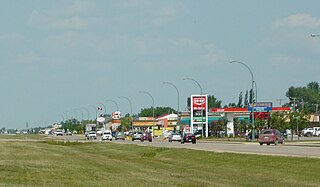
Swift Current is the sixth-largest city in the Canadian province of Saskatchewan. It is situated along the Trans Canada Highway 177 kilometres (110 mi) west of Moose Jaw, and 223 kilometres (139 mi) east of Medicine Hat, Alberta. As of 2024, Swift Current has an estimated population of 18,430, a growth of 1.32% from the 2016 census population of 16,604. The city is surrounded by the Rural Municipality of Swift Current No. 137.
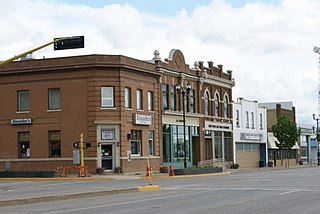
Estevan is the eleventh-largest city in Saskatchewan, Canada. It is approximately 16 km (9.9 mi) north of the Canada–United States border. The Souris River runs by the city. This city is surrounded by the Rural Municipality of Estevan No. 5.
Brandon—Souris is a federal electoral district in Manitoba, Canada, that has been represented in the House of Commons of Canada since 1953.
Yorkton—Melville is a federal electoral district in Saskatchewan, Canada, that has been represented in the House of Commons of Canada since 1968.
Cypress Hills—Grasslands is a federal electoral district in Saskatchewan, Canada, that has been represented in the House of Commons of Canada since 1997.
Winnipeg North is a federal electoral district in Canada that has been represented in the House of Commons of Canada since 1917. It covers the northern portion of Winnipeg, Manitoba.
Golden is a town in southeastern British Columbia, Canada, 262 kilometres (163 mi) west of Calgary, Alberta, and 713 kilometres (443 mi) east of Vancouver.
Regina—Qu'Appelle is a federal electoral district in Saskatchewan, Canada, that has been represented in the House of Commons of Canada from 1904 to 1968 and since 1988.
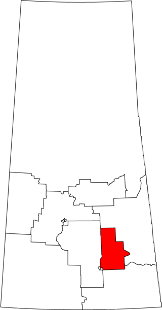
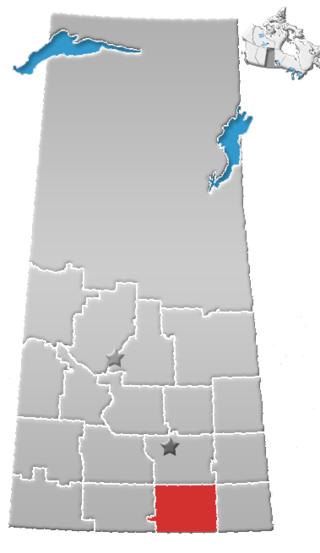
Souris—Moose Mountain is a federal electoral district in Saskatchewan, Canada, that has been represented in the House of Commons of Canada since 1988.
Regina—Wascana is a federal electoral district in Saskatchewan, Canada, that has been represented in the House of Commons of Canada since 1988.
Martensville is a city located in Saskatchewan, Canada, just 8 kilometres (5.0 mi) north of Saskatoon, 10 kilometres (6.2 mi) west of the city of Warman and 14 kilometres (8.7 mi) southwest of Clarkboro Ferry which crosses the South Saskatchewan River. It is a bedroom community of Saskatoon. It is surrounded by the Rural Municipality of Corman Park No. 344. The community is served by the Saskatoon/Richter Field Aerodrome located immediately west of the city across Highway 12, as well as by Saskatoon's John G. Diefenbaker International Airport, only a few miles to the south.
The population withinRegina, Saskatchewan's metropolitan area was 236,481 as of 2016 Canada Census with an annual growth rate of 2.4%.
Division No. 2 is one of eighteen census divisions in the province of Saskatchewan, Canada, as defined by Statistics Canada. It is located in the south-southeastern part of the province, on the United States border. The most populous community in this division is Weyburn.
Warman (/ˈwɔrmən/) is the ninth-largest city in the Canadian province of Saskatchewan. It is located approximately 20 kilometres (12 mi) north of the city of Saskatoon, and 5 kilometres (3.1 mi) northeast of the city of Martensville. According to the 2021 census, Warman is the fastest growing municipality in Saskatchewan, and was the fastest growing municipality in Canada between 2011 and 2016. Warman is a bedroom community of Saskatoon. The current mayor is Gary Philipchuk.
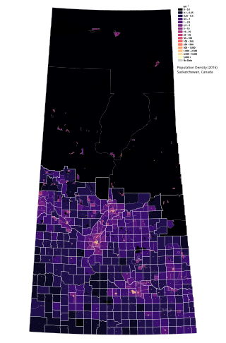
Saskatchewan is the middle province of Canada's three Prairie provinces. It has an area of 651,900 km2 (251,700 mi2) and a population of 1,132,505 (Saskatchewanians) as of 2021. Saskatchewan's population is made of 50.3% women and 49.7% men. Most of its population lives in the Southern half of the province.
The Saskatoon region is the greater metropolitan area of Saskatoon, Saskatchewan. As of 2021 the Statistics Canada estimates the region's population to be 317,480 people.
Sherwood Park—Fort Saskatchewan is a federal electoral district in Alberta, Canada, that has been represented in the House of Commons of Canada since 2015.
Moose Jaw—Lake Centre—Lanigan is a federal electoral district in Saskatchewan, Canada, represented in the House of Commons of Canada since 2015. It encompasses a portion of Saskatchewan formerly included in the electoral districts of Blackstrap, Palliser, Regina—Lumsden—Lake Centre, Souris—Moose Mountain, Wascana and Saskatoon—Humboldt.
Regina—Lewvan is a federal riding in Saskatchewan, made up of parts of the former Palliser and Regina—Lumsden—Lake Centre ridings within the city limits of Regina.
{{cite web}}
: CS1 maint: multiple names: authors list (link)