
Lloydminster is a city in Canada which has the unusual geographic distinction of straddling the provincial border between Alberta and Saskatchewan. The city is incorporated by both provinces as a single city with a single municipal administration.

Dalmeny is a town in the central part of Saskatchewan, Canada, named after Dalmeny, Scotland. The town is located in the rural municipality of Corman Park, and is about 26.8 km north of Saskatoon. The Dominion Land Survey description of Dalmeny's location is Section 10 Twp 39 Rge 6 W3.
Landis is a village in the Canadian province of Saskatchewan within the Rural Municipality of Reford No. 379 and Census Division No. 13. The village is about 51 km (32 mi) south of Wilkie and about 128 km (80 mi) west from the City of Saskatoon on Highway 14. From 1907 to 1909, the post office at Section 23, Township 37, Range 18 west of the 3rd meridian, was known as Daneville. In 1925, Landis was a Canadian National Railway Station on the Grand Trunk Pacific Railway line.
Pelly is a village in the Canadian province of Saskatchewan within the Rural Municipality of St. Philips No. 301 and Census Division No. 9.
Division No. 2 is one of eighteen census divisions in the province of Saskatchewan, Canada, as defined by Statistics Canada. It is located in the south-southeastern part of the province, on the United States border. The most populous community in this division is Weyburn.
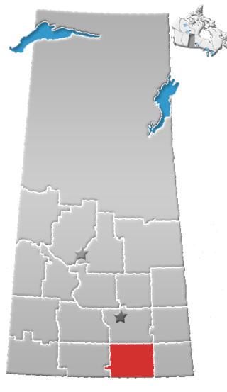
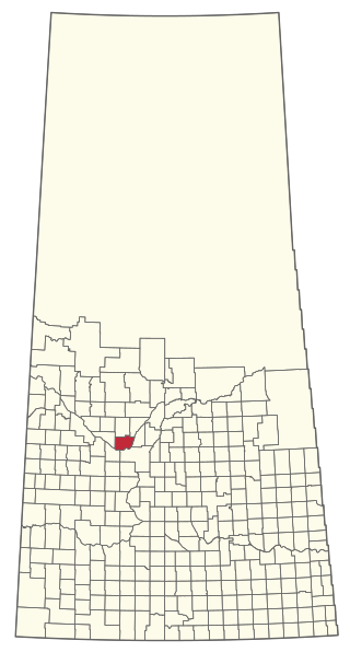
Wilcox is a village in the Canadian province of Saskatchewan within the Rural Municipality of Bratt's Lake No. 129 and Census Division No. 6. It is approximately 41 kilometres (25 mi) south of the City of Regina.
Calder is a village in the Canadian province of Saskatchewan within the Rural Municipality of Calder No. 241 and Census Division No. 9. The village lies approximately 56 km east of the City of Yorkton and 35 km west of Roblin, Manitoba, approximately 5 km south of Highway 8 and Highway 10.

The Rural Municipality of Deer Forks No. 232 is a rural municipality (RM) in the Canadian province of Saskatchewan within Census Division No. 8 and SARM Division No. 3. Located in the southwest portion of the province, it is adjacent to the Alberta boundary, neighbouring Cypress County to the west.

Eyebrow is a village in the Canadian province of Saskatchewan within the Rural Municipality of Eyebrow No. 193 and Census Division No. 7. The community originated at the location that is now the abandoned community of Eskbank several kilometres to the south. Eyebrow is located at the intersection of Highway 367 and Highway 42; 84 km northwest of Moose Jaw, 154 km northwest of Regina and 196 km south of Saskatoon.
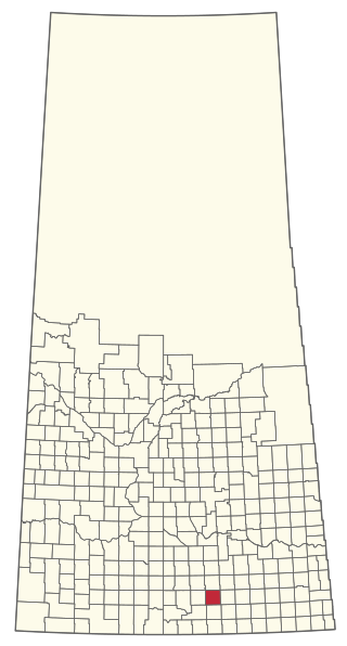
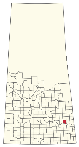
Kennedy is a village in the Canadian province of Saskatchewan within the Rural Municipality of Wawken No. 93 and Census Division No. 1. The village lies just south of Provincial Highway 48 about 3 km west of Highway 9.

Viscount is a village in the Canadian province of Saskatchewan within the Rural Municipality of Viscount No. 341 and Census Division No. 11. Viscount is located on Saskatchewan Highway 16, the Yellowhead Highway, in central Saskatchewan east of Colonsay and west of Lanigan. As of the Canada 2016 Census, Viscount had a population of 232.

Sheho is a village in the Canadian province of Saskatchewan within the Rural Municipality of Insinger No. 275 and Census Division No. 9. Sheho is located on Saskatchewan Highway 16, in southeast Saskatchewan between Foam Lake to the west and the City of Yorkton to the east. Sheho Lake post office first opened in 1891 at the legal land description of Sec.28, Twp.30, R.9, W2 before moving slightly and changing name to Sheho.

Theodore is a village in the Canadian province of Saskatchewan within the Rural Municipality of Insinger No. 275 and Census Division No. 9. Theodore is located on Saskatchewan Highway 16, the Yellowhead Highway, in southeastern Saskatchewan. The Theodore post office first opened in 1893 at the legal land description of Sec.1, Twp.28, R.7, W2. Theodore is located between Yorkton and Foam Lake.
The Rural Municipality of Great Bend No. 405 is a rural municipality (RM) in the Canadian province of Saskatchewan within Census Division No. 16 and SARM Division No. 6. Located in the west-central portion of the province, it is approximately 50 km (31 mi) to the northwest of Saskatoon.
Silton is a village in the Canadian province of Saskatchewan within the Rural Municipality of McKillop No. 220 and Census Division No. 6.

The Rural Municipality of Reciprocity No. 32 is a rural municipality (RM) in the Canadian province of Saskatchewan within Census Division No. 1 and SARM Division No. 1. It is located in the southeast portion of the province.

The Rural Municipality of Moose Mountain No. 63 is a rural municipality (RM) in the Canadian province of Saskatchewan within Census Division No. 1 and SARM Division No. 1. It is located in the south-east portion of the province.
The Rural Municipality of Norton No. 69 is a rural municipality (RM) in the Canadian province of Saskatchewan within Census Division No. 2 and SARM Division No. 2. It is located in the southeast portion of the province.

The Rural Municipality of Calder No. 241 is a rural municipality (RM) in the Canadian province of Saskatchewan within Census Division No. 9 and SARM Division No. 4.
The Rural Municipality of Grayson No. 184 is a rural municipality (RM) in the Canadian province of Saskatchewan within Census Division No. 5 and SARM Division No. 1.

