Related Research Articles

The Rural Municipality of Connaught No. 457 is a rural municipality (RM) in the Canadian province of Saskatchewan within Census Division No. 14 and SARM Division No. 4.

The Rural Municipality of Flett's Springs No. 429 is a rural municipality (RM) in the Canadian province of Saskatchewan within Census Division No. 15 and SARM Division No. 5.
Debden is a village in the Canadian province of Saskatchewan within the Rural Municipality of Canwood No. 494 and Census Division No. 16. The village is located on Highway 55 and is 94 km from the City of Prince Albert and 194 km from the City of Saskatoon. It is also the administrative headquarters of the Big River Cree First Nations band government. The village is at the edge of the Prince Albert National Park and with all the lakes nearby it becomes a popular area in the summer months.
BulyeaBUUL-yay is a village in the Canadian province of Saskatchewan within the Rural Municipality of McKillop No. 220 and Census Division No. 6.
Duval is a village in the Canadian province of Saskatchewan within the Rural Municipality of Last Mountain Valley No. 250 and Census Division No. 11. The village is located on Highway 20 approximately 93 km north of the City of Regina.
Edenwold is a village in the Canadian province of Saskatchewan within the Rural Municipality of Edenwold No. 158 and Census Division No. 6. It is located 45 km (28 mi) north of the City of Regina.
Liberty is a village in the Canadian province of Saskatchewan within the Rural Municipality of Big Arm No. 251 and Census Division No. 11. The village is located along Highway 2, 120 km (75 mi) north of the City of Regina.
Lang is a village in the Canadian province of Saskatchewan within the Rural Municipality of Scott No. 98 and Census Division No. 2. The village is located approximately 70 km southeast of the City of Regina.
Markinch is a village in the Canadian province of Saskatchewan within the Rural Municipality of Cupar No. 218 and Census Division No. 6. It is located about 68 km north of the City of Regina. It was named by settlers for Markinch, Scotland.
Minton is a village in the Canadian province of Saskatchewan within the Rural Municipality of Surprise Valley No. 9 and Census Division No. 2. It is on Highway 6 just north of its intersection with Highway 18, 19 km north of the Raymond-Regway Border Crossing on the Montana-Saskatchewan border. The village was named after Minton, Shropshire in England. The name was given by the Canadian Pacific Railway.
Parkside is a village in the Canadian province of Saskatchewan within the Rural Municipality of Leask No. 464 and Census Division No. 16.
Pleasantdale is a village in the Canadian province of Saskatchewan within the Rural Municipality of Pleasantdale No. 398 and Census Division No. 14.
Rush Lake is a village in the Canadian province of Saskatchewan within the Rural Municipality of Excelsior No. 166 and Census Division No. 7. Surrounding communities include Waldeck, Herbert, and the City of Swift Current.
St. Benedict is a village in the Canadian province of Saskatchewan within the Rural Municipality of Three Lakes No. 400 and Census Division No. 15. Located in the Carlton Trail Region of the province, it is 56 km (35 mi) north of the City of Humboldt off Highway 20.
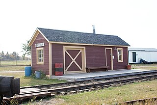
Smeaton is a village in the Canadian province of Saskatchewan within the Rural Municipality of Torch River No. 488 and Census Division No. 14. It is at the foot of Hanson Lake Road, which ends at Creighton near Flin Flon, Manitoba). Narrow Hills Provincial Park is 70 km north.
Weirdale is a village in the Canadian province of Saskatchewan within the Rural Municipality of Garden River No. 490 and Census Division No. 15. Weirdale is about 48 km northeast of the City of Prince Albert along Highway 55.
Quinton is a village in the Canadian province of Saskatchewan within the Rural Municipality of Mount Hope No. 279 and Census Division No. 10. The village is located on Highway 15 between the Town of Raymore and the Village of Punnichy. It is near the administrative office of the Kawacatoose First Nations.
Silton is a village in the Canadian province of Saskatchewan within the Rural Municipality of McKillop No. 220 and Census Division No. 6.
Ceylon is a village in the Canadian province of Saskatchewan within the Rural Municipality of The Gap No. 39 and Census Division No. 2. It is located alongside Gibson Creek, which is a tributary of Long Creek. No shops or businesses other than the bar remain.
Codette is a village in the Canadian province of Saskatchewan within the Rural Municipality of Nipawin No. 487 and Census Division No. 14. The village is located 10 km south of Nipawin at the junction of Highway 35 and Highway 789.
References
- ↑ "Urban Municipality Incorporations". Saskatchewan Ministry of Government Relations. Archived from the original on October 15, 2014. Retrieved June 1, 2020.
- ↑ "Saskatchewan Census Population" (PDF). Saskatchewan Bureau of Statistics. Archived from the original (PDF) on September 24, 2015. Retrieved May 31, 2020.
- ↑ "Saskatchewan Census Population". Saskatchewan Bureau of Statistics. Retrieved May 31, 2020.
- ↑ "Population and dwelling counts: Canada, provinces and territories, census divisions and census subdivisions (municipalities), Saskatchewan". Statistics Canada. February 9, 2022. Retrieved April 1, 2022.
- ↑ "Population and dwelling counts, for Canada, provinces and territories, and census subdivisions (municipalities), 2016 and 2011 censuses – 100% data (Saskatchewan)". Statistics Canada. February 8, 2017. Retrieved May 30, 2020.
- Everything Changes But The Memories ISBN 1-55056-064-6
| Cities |  | |
|---|---|---|
| Towns | ||
| Villages | ||
| Resort villages | ||
| Rural municipalities | ||
| First Nations | ||
| Indian reserves | ||
| Unincorporated communities | ||
Coordinates: 53°03′23″N104°09′16″W / 53.05639°N 104.15444°W
| | This Saskatchewan location article is a stub. You can help Wikipedia by expanding it. |