Val Marie (2021 population: 120) is a village in the Canadian province of Saskatchewan within the Rural Municipality of Val Marie No. 17 and Census Division 4. It is about 30 kilometres from the Canada–United States border.
Considered the gateway to the Grasslands National Park, Val Marie's economy is largely based on wheat farming, ranching, and tourism. Some natural gas has been found nearby. Employment includes agriculture, federal government (Grasslands National Park and Canadian Border Services), tourism (hotel and accommodation, restaurant, retail, etc) and a significant natural gas compressor relay station at the Montana border.
Fr. Louis-Pierre Gravel, missionary and promoter of much French Catholic immigration to southwestern Saskatchewan, originally called this settlement Rivière des Français after the nearby Frenchman River. For an unknown reason, he proposed a different name in a 1911 report to the superintendent of immigration: Libreval ("Free Valley"). Ultimately, neither of Gravel's suggestions were used, and Val Marie ("Valley of Mary"), was coined by Fr. Claude Passaplan, missionary priest in the area. Before coming to Val Marie, Passaplan served as the first Roman Catholic parish priest in Swift Current. [1]
The first European investigation of the area was conducted by the Palliser Expedition (1857–1859), supported by the Royal Geographical Society and the British Government, and led by John Palliser, a wealthy Irish landowner. He was accompanied by geologist James Hector, and various cartographers and botanists. They studied the natural resources and agricultural potential of the Palliser area — including Val Marie — and reported the place as dismally dry, prone to drought, and unfit for habitation. The dismissive conclusions slowed settlement in the area for decades.
Artifacts of native civilization are significant. In 1877, Tatanka Iyotake Sitting Bull crossed from the USA into Canada along the Frenchman River (which flows through Val Marie) after his victory over General Custer at Battle of the Little Bighorn.
The community of Val Marie – Valley of Mary – was founded in 1910 by Father Passaplan, Louis Denniel, and the brothers François and Léon Pinel. Most of the early settlers were ranchers and farmers from Quebec and France. Val Marie was incorporated as a village on September 13, 1926. [2] By 1939, two irrigation reservoirs were built near Val Marie by the PFRA (Prairie Farm Rehabilitation Agency) in coordination with Ducks Unlimited. Over 10,000 acres (40 km2) are irrigated through the system which provides some stabilization through droughts that plague the area.
Originally settled by French ranchers, the village remained largely ethnically French and by the 1950s had 450 people. Amenities then included three gasoline stations, a hospital, convent, bakery, bank, and several cafes and stores. The population declined significantly with low grain commodity prices and droughts in the 1980s. English is now universally spoken as the last unilingual Francophone resident died in 1981. [3] The Grasslands National Park has attracted some new people into the area; full-time and seasonal employees for the park, as well as recent retirees now call Val Marie home.
On August 14, 2004, Grasslands – Where Heaven Meets Earth, a site-specific art performance, was held in the community and park. The event was a collaboration of Canadian artists including Bill Coleman, Edward Poitras, Gordon Monahan, and Margie Gillis.
The West Block of Grasslands National Park lies 10 km east of Val Marie. The park is the only place in Canada where black-tailed prairie dog colonies are found. In 2006, plains bison were re-introduced into the park. Hiking in the badlands and viewing wildlife in the park are primary visiting activities. The park is divided into two blocks. The West Block is closest to Val Marie and the East Block is near Killdeer, SK. There are no plans to connect the two blocks. The West Block near Val Marie will be about 450 square kilometres when complete. It protects the Frenchman River Valley and is home to many unique species in Canada such as Plains Bison, Prairie Rattlesnake, Black-tailed Prairie Dogs, Burrowing Owls, Swift Fox, and many more. An official Parks Canada information centre is located in the town of Val Marie.
The park is home to over 12,000 teepee rings, indicating that the land was heavily used by indigenous people before it was used by cattle ranchers and homesteading. Primarily the Plains Cree and the Assiniboine used the land to hunt bison. The large 76 Ranch once had an office and many sections of land in the Val Marie area.
Located within Palliser's Triangle, Val Marie has a semi-arid climate (Köppen climate classification BSk ). Val Marie has a weather station with daily records since 1937. [4] It can be a harsh climate, cold and windswept in the winter and often very dry for prolonged periods, broken sometimes by extremely intense rainfalls during the summer. Val Marie is sometimes the national hotspot in Canada on a given summer day. Val Marie gets more days of sunlight per year than anywhere else in Canada. On average, Val Marie receives 352.5 mm (13.88 in) of precipitation per year and about two thirds of that is snow.
The coldest temperature ever recorded in Val Marie is −49.4 °C (−56.9 °F) on January 20, 1954. The hottest is 41.1 °C (106.0 °F) on July 4, 1937, which came close to being broken on July 23, 2007, when the temperature rose to 40.6 °C (105.1 °F), and again on August 11, 2018, when the temperature rose to 40.9 °C (105.6 °F). The preceding day, August 10, saw a maximum of 40.0 °C (104.0 °F). [5]
The record one-day rainfall is 86.4 mm (3.40 in) on July 3, 2000. The record one-day snowfall is 45.7 cm (18.0 in) April 2, 1940.
Climate data for Val-Marie (1981–2010) | |||||||||||||
---|---|---|---|---|---|---|---|---|---|---|---|---|---|
Month | Jan | Feb | Mar | Apr | May | Jun | Jul | Aug | Sep | Oct | Nov | Dec | Year |
Record high °C (°F) | 13.0 (55.4) | 19.0 (66.2) | 23.0 (73.4) | 31.7 (89.1) | 36.0 (96.8) | 38.5 (101.3) | 41.1 (106.0) | 40.9 (105.6) | 38.9 (102.0) | 30.6 (87.1) | 24.0 (75.2) | 17.8 (64.0) | 41.1 (106.0) |
Mean daily maximum °C (°F) | −4.3 (24.3) | −1.7 (28.9) | 3.6 (38.5) | 12.3 (54.1) | 18.1 (64.6) | 22.8 (73.0) | 26.7 (80.1) | 26.5 (79.7) | 20.0 (68.0) | 12.6 (54.7) | 3.7 (38.7) | −3.3 (26.1) | 11.4 (52.5) |
Daily mean °C (°F) | −10.8 (12.6) | −8.3 (17.1) | −2.8 (27.0) | 4.7 (40.5) | 10.7 (51.3) | 15.6 (60.1) | 18.5 (65.3) | 17.9 (64.2) | 11.5 (52.7) | 4.7 (40.5) | −3.1 (26.4) | −9.8 (14.4) | 4.1 (39.4) |
Mean daily minimum °C (°F) | −17.1 (1.2) | −14.9 (5.2) | −9.1 (15.6) | −2.9 (26.8) | 3.2 (37.8) | 8.3 (46.9) | 10.3 (50.5) | 9.2 (48.6) | 3.0 (37.4) | −3.3 (26.1) | −10.0 (14.0) | −16.2 (2.8) | −3.3 (26.1) |
Record low °C (°F) | −49.4 (−56.9) | −47.8 (−54.0) | −40.6 (−41.1) | −28.3 (−18.9) | −14.4 (6.1) | −6.7 (19.9) | −0.6 (30.9) | −3.9 (25.0) | −13.9 (7.0) | −30.0 (−22.0) | −36.7 (−34.1) | −46.7 (−52.1) | −49.4 (−56.9) |
Average precipitation mm (inches) | 14.8 (0.58) | 9.1 (0.36) | 17.5 (0.69) | 19.3 (0.76) | 52.5 (2.07) | 74.1 (2.92) | 56.5 (2.22) | 33.5 (1.32) | 30.7 (1.21) | 17.7 (0.70) | 14.6 (0.57) | 12.2 (0.48) | 352.5 (13.88) |
Average rainfall mm (inches) | 0.2 (0.01) | 0.3 (0.01) | 3.4 (0.13) | 13.5 (0.53) | 48.0 (1.89) | 74.1 (2.92) | 56.5 (2.22) | 33.5 (1.32) | 30.0 (1.18) | 12.2 (0.48) | 3.0 (0.12) | 1.0 (0.04) | 262 (10.3) |
Average snowfall cm (inches) | 14.6 (5.7) | 8.8 (3.5) | 14.1 (5.6) | 5.8 (2.3) | 4.8 (1.9) | 0.0 (0.0) | 0.0 (0.0) | 0.0 (0.0) | 0.7 (0.3) | 5.5 (2.2) | 11.8 (4.6) | 11.3 (4.4) | 77.3 (30.4) |
Source: Environment Canada [6] [7] |
Year | Pop. | ±% |
---|---|---|
1931 | 133 | — |
1936 | 147 | +10.5% |
1941 | 306 | +108.2% |
1946 | 301 | −1.6% |
1951 | 357 | +18.6% |
1956 | 383 | +7.3% |
1961 | 443 | +15.7% |
1966 | 385 | −13.1% |
1971 | 307 | −20.3% |
1976 | 253 | −17.6% |
1981 | 238 | −5.9% |
1986 | 204 | −14.3% |
1991 | 219 | +7.4% |
1996 | 157 | −28.3% |
2001 | 134 | −14.6% |
2006 | 137 | +2.2% |
2011 | 130 | −5.1% |
2016 | 126 | −3.1% |
2021 | 120 | −4.8% |
Source: Statistics Canada [8] [9] [10] [11] [12] [13] [14] [15] [16] [17] |
In the 2021 Census of Population conducted by Statistics Canada, Val Marie had a population of 120 living in 64 of its 86 total private dwellings, a change of
In the 2016 Census of Population, the Village of Val Marie recorded a population of 126 living in 66 of its 80 total private dwellings, a
The village recorded its largest population in 1961, when 443 people lived in Val Marie. [10]
Val Marie holds many annual events such as the Val Marie Bob Larson Memorial Rodeo, Lion's Senior's Supper, Lion's Sports Day, and a Canada Day parade, among others. Between the Val Marie Hotel, Prairie Wind & Silver Sage (the museum), theatre/hall, and arena, there are many events taking place weekly.
Val Marie is home to two municipally declared heritage buildings.
In 2018, Grasslands National Park had almost 20,000 visitors through the park, in cooperation with the Canada 150 Marketing campaign. The number of tourists that come to Val Marie for annual events or to use the Port of Monchy Border Crossing is unknown.
The Village of Val Marie has partnered with the Cypress Hills Destination Area to promote Val Marie as a tourist destination.
Services in the community include a gas station, a hotel/bar, a museum (which also includes a gift shop, coffee shop and art gallery), a café, a campground, art galleries, bed and breakfasts, an old convent that has been converted to an inn, a movie theatre, yoga studio, a hockey arena and curling rink, a library, a community centre, a town square, and a community-owned grocery store. Some services are only available seasonally. Val Marie is also home to a school (kindergarten to grade 12) and the Val Marie Early Learning Centre which offers preschool programming. A basic life support ambulance services the region. The nearest full-service centre is the city of Swift Current, located 120 km north on Highway 4.
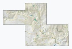
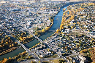
Red Deer is a city in Alberta, Canada, located midway on the Calgary–Edmonton Corridor. Red Deer serves central Alberta, and its key industries include health care, retail trade, construction, oil and gas, hospitality, manufacturing and education. It is surrounded by Red Deer County and borders on Lacombe County. The city is in aspen parkland, a region of rolling hills, alongside the Red Deer River.
Grande Prairie is a city in northwestern Alberta, Canada, within the southern portion of an area known as Peace River Country. It is located at the intersection of Highway 43 and Highway 40, approximately 456 km (283 mi) northwest of Edmonton. The city is surrounded by the County of Grande Prairie No. 1.
Leduc is a city in the province of Alberta, Canada. It is 33 km (21 mi) south of the provincial capital of Edmonton and is part of the Edmonton Metropolitan Region.
Lloydminster is a city in Canada which has the unusual geographic distinction of straddling the provincial border between Alberta and Saskatchewan. The city is incorporated by both provinces as a single city with a single municipal administration.
Okotoks is a town in the Calgary Region of Alberta, Canada. It is on the Sheep River, approximately 38 km (24 mi) south of Downtown Calgary. Okotoks has emerged as a bedroom community of Calgary. According to the 2021 Federal Census, the town has a population of 30,214, making it the largest town in Alberta.
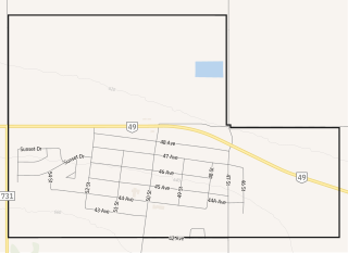
Fairview is a town in Peace Country, Alberta, Canada. It is located 82 km (51 mi) southwest of Peace River and 115 km (71 mi) north of Grande Prairie at the intersection of Highway 2 and Highway 64A.
Brooks is a city in southeast Alberta, Canada in the County of Newell. It is on Highway 1 and the Canadian Pacific Kansas City railway, approximately 186 km (116 mi) southeast of Calgary, and 110 km (68 mi) northwest of Medicine Hat. The city has an elevation of 760 m (2,490 ft).
Stony Plain is a town in the Edmonton Metropolitan Region of Alberta, Canada that is surrounded by Parkland County. It is west of Edmonton adjacent to the City of Spruce Grove and sits on Treaty 6 land.
Strathmore is a town located in southern Alberta, Canada that is surrounded by Wheatland County. It is along the Trans-Canada Highway approximately 50 kilometres (30 mi) east of Calgary.
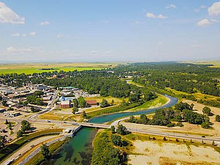
High River is a town within the Calgary Metropolitan Region of Alberta, Canada. It is approximately 68 kilometres (42 mi) south of Calgary, at the junction of Alberta Highways 2 and 23. High River had a population of 14,324 in 2021.
Grande Cache is a hamlet in West-Central Alberta, Canada within and administered by the Municipal District of Greenview No. 16. It is located on Highway 40 approximately 145 kilometres (90 mi) northwest of Hinton and 435 kilometres (270 mi) west of Edmonton. Grande Cache overlooks the Smoky River, is at the northern edge of Alberta's Rockies, and serves as a gateway to the Willmore Wilderness Park. The hamlet held town status prior to 2019.
Spirit River is a town in northern Alberta, Canada. It is approximately 78 km (48 mi) north of Grande Prairie at the junction of Highway 49 and Highway 731.
Hythe is a hamlet in northwest Alberta, Canada within the County of Grande Prairie No. 1. It is located on Highway 43 approximately 58 km (36 mi) northwest of the City of Grande Prairie and 73 km (45 mi) southeast of the City of Dawson Creek, British Columbia. It held village status prior to July 2021.
Rycroft is a village in northern Alberta, Canada. It is approximately 68 km (42 mi) north of Grande Prairie and 7 km (4.3 mi) east of Spirit River. Dunvegan Provincial Park is located 20 km north of the community.
Maple Creek is a town in the Cypress Hills of southwest Saskatchewan, Canada. It is surrounded by the Rural Municipality of Maple Creek No. 111. The population was 2,176 at the 2021 Census.
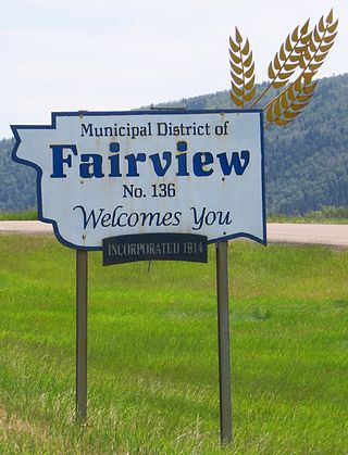
The Municipal District of Fairview No. 136 is a municipal district (MD) in northwestern Alberta, Canada. It is located in Census Division 19.
The Municipal District of Peace No. 135 is a municipal district (MD) in northwestern Alberta, Canada. Located in Census Division No. 19, its municipal office is located outside but adjacent to the Village of Berwyn.
The Rural Municipality of Senlac No. 411 is a rural municipality (RM) in the Canadian province of Saskatchewan within Census Division No. 13 and SARM Division No. 6. Located in the west-central portion of the province, it is adjacent to the Alberta boundary.
The Rural Municipality of Val Marie No. 17 is a rural municipality (RM) in the Canadian province of Saskatchewan within Census Division No. 4 and SARM Division No. 3. Located in the southwest portion of the province, it is adjacent to the Canada–United States border, neighbouring Phillips County in Montana.
Loverna is an unincorporated hamlet in Antelope Park Rural Municipality No. 322, Saskatchewan, Canada. The population of Loverna was 5 at the 2001 Canada Census. The hamlet is approximately 50 km northwest of the Town of Kindersley at the intersection of Highway 772 and Range road 290. The Grand Trunk Pacific played a big role in the town's economy when it was completed in 1913 on its way from Biggar, SK to Hemaruka, AB. The line was planned as a thorough route, however the planned connection to another line under construction at the time to Spondin, AB was never finished. The track was lightly built and poorly maintained and so could only support boxcars and lightweight hopper cars for grain loading. As well the line was restricted to special lightweight GMD-1 locomotives. During the drastic closure of uneconomic branch lines in the late 1970s and '80s the tracks west from Smiley through Loverna were closed. The Canadian Pacific Railway took over operation of the remaining track from a connection on their line at Dodsland to Smiley. This too was closed in 1996, and Loverna's population has since declined.