Edam | |
|---|---|
| Village of Edam | |
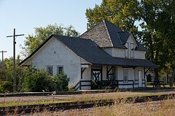 The historic Canadian Northern (later Canadian National) railway station in Edam | |
| Motto: Little piece of Holland in Saskatchewan | |
 Edam Location of Edam in Saskatchewan  Edam Edam (Canada) | |
| Coordinates: 53°11′N108°46′W / 53.183°N 108.767°W | |
| Country | Canada |
| Province | |
| Region | Central |
| Census division | 17 |
| Rural Municipality | Turtle River No. 469 |
| Post office Founded | 1908 |
| Village | 1911 |
| Government | |
| • Type | Municipal |
| • Governing body | Edam Village Council |
| • Mayor | Larry McDaid |
| • MLA | Larry Doke |
| • MP | Rosemarie Falk |
| Area | |
• Total | 1.19 km2 (0.46 sq mi) |
| Population (2016) | |
• Total | 480 |
| • Density | 403.4/km2 (1,045/sq mi) |
| Time zone | UTC−6 (Central Standard Time) |
| • Summer (DST) | UTC−5 |
| Postal code | S0M 0V0 |
| Highways | |
| Railways | Canadian National Railway |
| Website | Village of Edam |
| [1] [2] [3] [4] | |
Edam (2016 population: 480) is a village in the Canadian province of Saskatchewan within the Rural Municipality of Turtle River No. 469 and Census Division No. 17. Edam is located off Highway 26, south of Turtleford and north of Vawn.
Contents
The village is known as a "Little piece of Holland in Saskatchewan". Established in 1907, the hamlet was named for the city of Edam in the Netherlands, after the name 'Amsterdam' was rejected by the Saskatchewan Government Office as "too long". [5]
