Abbey, Saskatchewan

Last updated

Abbey
Village of Abbey
Canada Saskatchewan location map.svg
Red pog.svg
Abbey
Canada location map 2.svg
Red pog.svg
Abbey
Coordinates: 50°44′13″N108°45′27″W / 50.73694°N 108.75750°W / 50.73694; -108.75750 [1] Coordinates: 50°44′13″N108°45′27″W / 50.73694°N 108.75750°W / 50.73694; -108.75750 [2]
CountryCanada
Province Saskatchewan
Region Southwest
Census division 8
Rural Municipality Miry Creek No. 229
Post office foundedAugust 1, 1913
Incorporated (village)September 2, 1913
Government
  Governing bodyAbbey Village Council [3]
   Mayor Kent Haggart [3]
   Administrator Karen Paz [3]
Area
[4]
  Total0.73 km2 (0.28 sq mi)
Elevation
681 m (2,235 ft)
Population
 (2021) [4]
  Total100
  Density137.6/km2 (356/sq mi)
Time zone UTC-06:00 (CST)
Postal code
S0N 0A0
Area code(s) 306
Highways Saskatchewan Highway 32 (jct).svg Hwy 32
Hwy 783
[5] [6] [7]

Abbey (2021 population: 122 [4] ) is a village in the Canadian province of Saskatchewan within the Rural Municipality of Miry Creek No. 229 and Census Division No. 8. This village is in the south-western region of the province, north-west of the city of Swift Current. Abbey is serviced by Highway 32 near Highway 738.

Contents

History

In 1910, the first post office used by area residents was Longworth, located in the home of Cassie Baldwin. [8] The townsite]]f Abbey was originally owned by a man named D.F. Kennedy. In 1913, the Canadian Pacific Railway (CPR) bought a quarter section of land from him to build a rail line. [8] The CPR gave Mr. Kennedy the honour of naming the community, giving it the name Abbey - the name of the Kennedy farm in Ireland. [9] Abbey incorporated as a village on September 2, 1913. [10]

Abbey Fire Hall

Abbey has one municipal heritage property on the Canadian Register of Historic Places, the Abbey Fire Hall. Constructed in 1919 in response to a large fire that threatened the community in September 1918, the fire station was part of an upgrade to fire protection in Abbey. The station remained in service until a new fire station was constructed in 1975. The station is currently not in use, however the siren on the station tower is still used to signal emergencies in the community. [11]

Parks and recreation

Abbey Golf Club is a golf course about 0.5 km (0.31 mi) south-east of Abbey. It was built in 1950 and is a par 35, 9-hole course with sand greens and a total length of 2085 yards. [12] [13]

Demographics

Population history
(1981–2016)
YearPop.±%
1981218    
1986198−9.2%
1991190−4.0%
1996 162−14.7%
2001 137−15.4%
2006 130−5.1%
2011 115−11.5%
2016 129+12.2%
2021 100−22.5%
Source: Statistics Canada via Saskatchewan Bureau of Statistics [14] [15]

In the 2021 Canadian census conducted by Statistics Canada, the Village of Abbey recorded a population of 100 living in 59 of its 85 total private dwellings, a −22.5 change from its 2016 population of 129. With a land area of 0.73 km2 (0.28 sq mi), it had a population density of

In the 2016 Canadian census conducted by Statistics Canada, the Village of Abbey recorded a population of 129 living in 65 of its 88 total private dwellings, a

In the 2011 Canadian census, the Village of Abbey recorded a population of 115, a

Geography

Abbey is located south of the South Saskatchewan River and north of the Great Sand Hills [18]

Climate

Abbey experiences a semi-arid climate (Köppen climate classification BSk) with long, cold, dry winters and short, warm summers. Precipitation is low, with an annual average of 316.2 mm (12.45 in), and is concentrated in the warmer months.

Climate data for Abbey
Climate ID: 4020020; coordinates 50°42′N108°47′W / 50.700°N 108.783°W / 50.700; -108.783 (Calgary International Airport) ; elevation: 694.9 m (2,280 ft); 1981-2010 normals
MonthJanFebMarAprMayJunJulAugSepOctNovDecYear
Record high °C (°F)13.9
(57.0)
17.0
(62.6)
25.0
(77.0)
31.5
(88.7)
35.0
(95.0)
39.0
(102.2)
39.0
(102.2)
41.1
(106.0)
37.8
(100.0)
33.9
(93.0)
25.0
(77.0)
16.0
(60.8)
41.1
(106.0)
Average high °C (°F)−6.3
(20.7)
−3.3
(26.1)
3.3
(37.9)
12.5
(54.5)
18.6
(65.5)
22.8
(73.0)
26.6
(79.9)
26.1
(79.0)
19.5
(67.1)
12.0
(53.6)
1.4
(34.5)
−4.6
(23.7)
10.7
(51.3)
Average low °C (°F)−16.1
(3.0)
−13.3
(8.1)
−7.0
(19.4)
−0.7
(30.7)
4.9
(40.8)
9.5
(49.1)
12.0
(53.6)
11.3
(52.3)
5.8
(42.4)
−0.5
(31.1)
−8.3
(17.1)
−14.3
(6.3)
−1.4
(29.5)
Record low °C (°F)−43.3
(−45.9)
−42.0
(−43.6)
−35.0
(−31.0)
−20.0
(−4.0)
−11.0
(12.2)
−4.0
(24.8)
2.5
(36.5)
0.0
(32.0)
−7.8
(18.0)
−27.0
(−16.6)
−36.0
(−32.8)
−44.0
(−47.2)
−44.0
(−47.2)
Average precipitation mm (inches)10.6
(0.42)
8.3
(0.33)
14.6
(0.57)
20.9
(0.82)
41.0
(1.61)
72.1
(2.84)
46.6
(1.83)
35.5
(1.40)
27.0
(1.06)
14.1
(0.56)
12.1
(0.48)
13.3
(0.52)
316.2
(12.45)
Average rainfall mm (inches)0.0
(0.0)
0.2
(0.01)
3.0
(0.12)
13.7
(0.54)
37.6
(1.48)
72.1
(2.84)
46.6
(1.83)
35.5
(1.40)
25.2
(0.99)
8.1
(0.32)
1.7
(0.07)
0.3
(0.01)
244.0
(9.61)
Average snowfall cm (inches)10.6
(4.2)
8.1
(3.2)
11.6
(4.6)
7.3
(2.9)
3.4
(1.3)
0.0
(0.0)
0.0
(0.0)
0.0
(0.0)
1.8
(0.7)
6.1
(2.4)
10.4
(4.1)
13.0
(5.1)
72.2
(28.4)
Average precipitation days (≥ 0.2 mm)3.92.63.84.16.18.46.35.04.53.33.64.355.8
Average rainy days (≥ 0.2 mm)0.040.080.443.005.608.406.305.004.402.000.520.1235.80
Average snowy days (≥ 0.2 cm)3.902.503.401.400.740.000.000.000.221.403.204.2020.90
Source: Environment and Climate Change Canada [19]

See also

Related Research Articles

Loon Lake, Saskatchewan Village in Saskatchewan, Canada

Loon Lake is a village in the Canadian province of Saskatchewan within the Rural Municipality of Loon Lake No. 561 and Census Division No. 17. The Makwa Sahgaiehcan First Nation reserve is to the east of the village. The village is located on Highway 26 north-east of the city of Lloydminster.

Semans is a village in the Canadian province of Saskatchewan within the Rural Municipality of Mount Hope No. 279 and Census Division No. 10. The village is located approximately 125 km north of the City of Regina and 195 km southeast of the City of Saskatoon.

Aylsham is a village in the Canadian province of Saskatchewan within the Rural Municipality of Nipawin No. 487 and Census Division No. 14. The village is approximately 65 km (40 mi) northeast of the City of Melfort.

Rural Municipality of Fillmore No. 96 Rural municipality in Saskatchewan, Canada

The Rural Municipality of Fillmore No. 96 is a rural municipality (RM) in the Canadian province of Saskatchewan within Census Division No. 2 and SARM Division No. 1. It is located in the south-east portion of the province along Highway 33.

Stewart Valley

Stewart Valley is a village in the Canadian province of Saskatchewan within the Rural Municipality of Saskatchewan Landing No. 167 and Census Division No. 8. It is on Highway 4, just south of the South Saskatchewan River, approximately 35 km (22 mi) north of the City of Swift Current in southern Saskatchewan. It is along the remains of the historic Swift Current-Battleford Trail.

Marquis is a village in the Canadian province of Saskatchewan within the Rural Municipality of Marquis No. 191 and Census Division No. 7. It is on Highway 42 about 32 km northwest of Moose Jaw.

Frontier, Saskatchewan Village in Saskatchewan, Canada

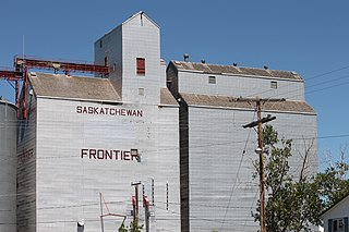
Frontier is a village in the Canadian province of Saskatchewan within the Rural Municipality of Frontier No. 19 and Census Division No. 4. Frontier is on Highway 18 and is served by the Frontier Airport located (3.7 km) south of the village.

Rural Municipality of Reno No. 51 Rural municipality in Saskatchewan, Canada

The Rural Municipality of Reno No. 51 is a rural municipality (RM) in the Canadian province of Saskatchewan within Census Division No. 4 and SARM Division No. 3. Located in the southwest corner of the province, it is adjacent to the United States border to the south and the Alberta boundary to the west.

Elbow, Saskatchewan Village in Saskatchewan, Canada

Elbow is a village in the Canadian province of Saskatchewan within the Rural Municipality of Loreburn No. 254 and Census Division No. 11. Elbow was founded in 1909, near what is now Lake Diefenbaker. It is 8 km northwest of Mistusinne, 10 km northwest of Douglas Provincial Park and 16 km southeast of Loreburn. The village got its name from its position on the elbow of the South Saskatchewan River.

Fenwood is a village in the Canadian province of Saskatchewan within the Rural Municipality of Stanley No. 215 and Census Division No. 5.

Golden Prairie is a village in the Canadian province of Saskatchewan within the Rural Municipality of Big Stick No. 141 and Census Division No. 8.

Kennedy is a village in the Canadian province of Saskatchewan within the Rural Municipality of Wawken No. 93 and Census Division No. 1. The village lies just south of Provincial Highway 48 about 3 km west of Highway 9.

McLean is a village in the Canadian province of Saskatchewan within the Rural Municipality of South Qu'Appelle No. 157 and Census Division No. 6. It is on Highway between Qu'Appelle and Balgonie.

Paynton Village in Saskatchewan, Canada

Paynton is a village in the Canadian province of Saskatchewan within the Rural Municipality of Paynton No. 470 and Census Division No. 17. It is administrative centre of the Little Pine Cree First Nation band government.

Pennant is a village in the Canadian province of Saskatchewan within the Rural Municipality of Riverside No. 168 and Census Division No. 8.

Waseca is a village in the Canadian province of Saskatchewan within the Rural Municipality of Eldon No. 471 and Census Division No. 17. Waseca is located on Highway 16, the Yellowhead Highway, in northwest Saskatchewan. Waseca is located east of Lashburn and west of Maidstone. It was probably named after Waseca, Minnesota. A former resident of the Waseca area (1923-1942) has stated she was told that Waseca was an Indigenous name meaning "looking upwards" and the name was assigned when the CN railway station was built.

Sceptre, Saskatchewan Village in Saskatchewan, Canada

Sceptre is a village in the Canadian province of Saskatchewan within the Rural Municipality of Clinworth No. 230 and Census Division No. 8.

Shamrock is a village in the Canadian province of Saskatchewan within the Rural Municipality of Shamrock No. 134 and Census Division No. 7.

Smiley is a village in the Canadian province of Saskatchewan within the Rural Municipality of Prairiedale No. 321 and Census Division No. 13. The village is located approximately 20 km northwest of the Town of Kindersley at the intersection of Highway 307 and Highway 772. The Grand Trunk Pacific Railway was completed in 1913 bringing an economic boom to the village's early years. On April 26, 1987 the Dodsland subdivision between Dodsland and Smiley was transferred to the Canadian Pacific Railway. Due to the close proximity to major grain centres such as Kindersley, CPR put the line up for abandonment and was granted permission to remove the track by the Canadian Transportation Agency on October 29, 1997.

Young, Saskatchewan Village in Saskatchewan, Canada

Young is a village in the Canadian province of Saskatchewan within the Rural Municipality of Morris No. 312. The economy is dominated by local agriculture and the nearby Mosaic Potash mine.

References

  1. "Abbey". Geographical Names Data Base . Natural Resources Canada.
  2. "Abbey". Geographical Names Data Base . Natural Resources Canada.
  3. 1 2 3 Abbey Village Council
  4. 1 2 3 4 "Census Profile, 2021 Census of Population Data table Abbey, Village (VL) Saskatchewan [Census subdivision]" . Retrieved March 8, 2022.
  5. National Archives, Archivia Net. "Post Offices and Postmasters". Archived from the original on October 6, 2006. Retrieved July 15, 2014.
  6. Government of Saskatchewan, MRD Home. "Municipal Directory System". Archived from the original on January 15, 2016. Retrieved July 15, 2014.
  7. Commissioner of Canada Elections, Chief Electoral Officer of Canada (2005). "Elections Canada On-line". Archived from the original on April 21, 2007. Retrieved July 15, 2014.
  8. 1 2 Russell, E. T. (1973), What's In a Name?, Saskatoon, Saskatchewan: Western Producer Book Service, p1
  9. Our Roots History of Abbey Archived 2011-06-14 at the Wayback Machine Retrieved on 2008-12-14
  10. "Urban Municipality Incorporations". Saskatchewan Ministry of Government Relations. Archived from the original on October 15, 2014. Retrieved June 1, 2020.
  11. Abbey Fire Hall Heritage Property Details Archived March 14, 2012, at the Wayback Machine
  12. "Abbey Golf Club in Abbey, Saskatchewan, Canada | GolfPass".
  13. "| Tourism Saskatchewan". Archived from the original on May 13, 2019.
  14. "Saskatchewan Census Population" (PDF). Saskatchewan Bureau of Statistics. Archived from the original (PDF) on September 24, 2015. Retrieved May 31, 2020.
  15. "Saskatchewan Census Population". Saskatchewan Bureau of Statistics. Retrieved May 31, 2020.
  16. "Population and dwelling counts, for Canada, provinces and territories, and census subdivisions (municipalities), 2016 and 2011 censuses – 100% data (Saskatchewan)". Statistics Canada. February 8, 2017. Retrieved May 30, 2020.
  17. "Population and dwelling counts, for Canada, provinces and territories, and census subdivisions (municipalities), 2011 and 2006 censuses (Saskatchewan)". Statistics Canada. June 3, 2019. Retrieved May 30, 2020.
  18. "Great Sand Hills | Tourism Saskatchewan".
  19. "Canadian Climate Normals 1981-2010 Station Data". Environment and Climate Change Canada. November 25, 2021. Retrieved March 8, 2022.