Ridgedale is a village in the Canadian province of Saskatchewan within the Rural Municipality of Connaught No. 457 and Census Division No. 14. It is situated on the banks of the Carrot River.
Buena Vista is a village in the Canadian province of Saskatchewan within the Rural Municipality of Lumsden No. 189 and Census Division No. 6. The village is located 40 km (25 mi) north-west of Regina, on the southern shore of Last Mountain Lake just off Highway 54. It is bounded to the west by Regina Beach, demarcated by 16 Street.
Milden is a village in the Canadian province of Saskatchewan within the Rural Municipality of Milden No. 286 and Census Division No. 12. The village is located at the junction of Highway 15 and Highway 655 approximately 20 km west of Outlook on Highway 15.
Atwater is a village in the Canadian province of Saskatchewan within the Rural Municipality of Fertile Belt No. 183 and Census Division No. 5. The village is approximately 45 kilometres (28 mi) southeast of the city of Melville on Highway 629.
Chaplin is a village in the Canadian province of Saskatchewan within the Rural Municipality of Chaplin No. 164 and Census Division No. 7. The community is situated on the Trans-Canada Highway approximately 85 kilometres (53 mi) from Moose Jaw and 90 km from Swift Current. The main industries of Chaplin are Saskatchewan Minerals and farming/ranching.

The Rural Municipality of Lone Tree No. 18 is a rural municipality (RM) in the Canadian province of Saskatchewan within Census Division No. 4 and SARM Division No. 3. Located in the southwest portion of the province, it is southwest of the city of Swift Current. It is adjacent to the United States border, neighbouring Blaine County and Phillips County in Montana.
Storthoaks is a village in the Canadian province of Saskatchewan within the Rural Municipality of Storthoaks No. 31 and Census Division No. 1. The village is located approximately 129 km east of the City of Estevan on Highway 361 and 16 km west of the Saskatchewan-Manitoba border.
Coderre ) is a village in the Canadian province of Saskatchewan within the Rural Municipality of Rodgers No. 133 and Census Division No. 7. The village is located approximately 85 km southwest of the City of Moose Jaw on Highway 627.
Bjorkdale is a village in the Canadian province of Saskatchewan within the Rural Municipality of Bjorkdale No. 426 and Census Division No. 14. The village is at the junctions of Highways 23, 679, and 776, approximately 78 kilometres (48 mi) east of the city of Melfort.
Buchanan is a village in the Canadian province of Saskatchewan within the Rural Municipality of Buchanan No. 304 and Census Division No. 9.

Glenside is a village in the Canadian province of Saskatchewan within the Rural Municipality of Rudy No. 284 and Census Division No. 11. The village is located on Highway 219 approximately 20 km east of the Town of Outlook.
Hubbard is a village in the Canadian province of Saskatchewan within the Rural Municipality of Ituna Bon Accord No. 246 and Census Division No. 10.

St. Gregor is a village in the Canadian province of Saskatchewan within the Rural Municipality of St. Peter No. 369 and Census Division No. 15. It is approximately 20 km west of the Town of Watson on Highway 5.
Margo is a village in the Canadian province of Saskatchewan within the Rural Municipality of Sasman No. 336 and Census Division No. 10.
Pleasantdale is a village in the Canadian province of Saskatchewan within the Rural Municipality of Pleasantdale No. 398 and Census Division No. 14.
Shamrock is a village in the Canadian province of Saskatchewan within the Rural Municipality of Shamrock No. 134 and Census Division No. 7.
Silton is a village in the Canadian province of Saskatchewan within the Rural Municipality of McKillop No. 220 and Census Division No. 6. Access is from Highway 322.
Waldron is a village in the Canadian province of Saskatchewan within the Rural Municipality of Grayson No. 184 and Census Division No. 5.
Weekes is a village in the Canadian province of Saskatchewan within the Rural Municipality of Porcupine No. 395 and Census Division No. 14. The village is located 29 km east of the town of Porcupine Plain on Highway 23.
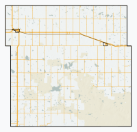
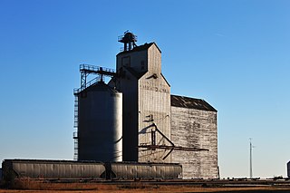
Osage is a village in the Canadian province of Saskatchewan within the Rural Municipality of Fillmore No. 96 and Census Division No. 2. The village is located on Highway 33, that runs south-east from Regina to Stoughton. The village has a grain elevator, post office, service station, and a two-sheet natural ice curling rink. Children from the area attend school in Fillmore, 13 km away. Osage celebrated its centennial in 2006.