Kisbey

Last updated

Kisbey
Village of Kisbey
Kisbey Saskatchewan old storefront.jpg
Old storefront in Kisbey
Canada Saskatchewan location map.svg
Red pog.svg
Location of Kisbey in Saskatchewan
Canada location map 2.svg
Red pog.svg
Kisbey (Canada)
Coordinates: 49°38′31″N102°40′26″W / 49.642°N 102.674°W / 49.642; -102.674
Country Canada
Province Saskatchewan
Region Southeast
Census division 1
Rural Municipality Brock No. 64
Government
  Type Municipal
  Governing body Kisbey Village Council
   Mayor Kalvin Nankivell
   Administrator Judy Graham
   MP Robert Kitchen
   MLA Dan D'Autremont
Area
[1]
  Total2.77 km2 (1.07 sq mi)
Population
 (2021) [2]
  Total158
  Density57.0/km2 (148/sq mi)
Time zone UTC-6 (CST)
Postal code
S0C 1L0
Area code 306
Highways Saskatchewan Highway 13 (jct).svg Hwy 13
Saskatchewan Rural Municipal Route.svg
Saskatchewan Route 605.svg
Hwy 605
Railways (Pulled)
[3] [4] [5] [6]

Kisbey (2016 population: 153) is a village in the Canadian province of Saskatchewan within the Rural Municipality of Brock No. 64 and Census Division No. 1. The village took its name from Richard Claude Kisbey (d. 1941), an Irish immigrant who settled in Estevan. [7]

Contents

History

Kisbey incorporated as a village on May 8, 1907. [8]

Demographics

Population history
(1971–2021)
YearPop.±%
1971260    
1976252−3.1%
1981228−9.5%
1986234+2.6%
1991219−6.4%
1996 209−4.6%
2001 199−4.8%
2006 185−7.0%
2011 217+17.3%
2016 153−29.5%
2021 158+3.3%
[9] Source: Statistics Canada via Saskatchewan Bureau of Statistics [10] [11]

In the 2021 Census of Population conducted by Statistics Canada, Kisbey had a population of 158 living in 77 of its 95 total private dwellings, a change of

In the 2016 Census of Population, the Village of Kisbey recorded a population of 153 living in 83 of its 95 total private dwellings, a

Sports

The Arcola/Kisbey Combines of the senior men's Big 6 Hockey League play at the local ice rink. [13]

See also

Related Research Articles

Brock is a village in the Canadian province of Saskatchewan within the Rural Municipality of Kindersley No. 290 and Census Division No. 13. The village is located 165 km southwest of the City of Saskatoon.

<span class="mw-page-title-main">Alida, Saskatchewan</span> Village in Saskatchewan, Canada

Alidaə-LEE-də is a village in the Canadian province of Saskatchewan within the Rural Municipality of Reciprocity No. 32 and Census Division No. 1. The village is approximately 85 km (53 mi) east of the City of Estevan. Farming and oil are the major local industries. Several ghost towns are in the vicinity, including Nottingham to the east, Auburnton, to the west, and Cantal to the north-west. With the investment of oil and other industries, the area continues to grow.

Neudorf is a village in the Canadian province of Saskatchewan within the Rural Municipality of McLeod No. 185 and Census Division No. 5. It is on Highway 22 east of Lemberg, and Abernethy, and west of Killaly.

<span class="mw-page-title-main">Rural Municipality of Storthoaks No. 31</span> Rural municipality in Saskatchewan, Canada

The Rural Municipality of Storthoaks No. 31 is a rural municipality (RM) in the Canadian province of Saskatchewan within Census Division No. 1 and SARM Division No. 1.

Aylsham is a village in the Canadian province of Saskatchewan within the Rural Municipality of Nipawin No. 487 and Census Division No. 14. The village is approximately 65 km (40 mi) northeast of the city of Melfort.

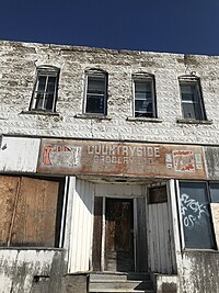
Storthoaks is a village in the Canadian province of Saskatchewan within the Rural Municipality of Storthoaks No. 31 and Census Division No. 1. The village is located approximately 129 km east of the City of Estevan on Highway 361 and 16 km west of the Saskatchewan-Manitoba border.

<span class="mw-page-title-main">Maryfield, Saskatchewan</span> Village in Saskatchewan, Canada

Maryfield is a village in the Canadian province of Saskatchewan within the Rural Municipality of Maryfield No. 91 and Census Division No. 1. The village lies south of the intersection of Highway 48 and Highway 600 and is about 8 km west of the Manitoba border. It is a junction point on the Canadian National Railway between the main line heading northwest towards Regina and a branch line heading southwest toward Carlyle and Lampman.

BulyeaBUUL-yay is a village in the Canadian province of Saskatchewan within the Rural Municipality of McKillop No. 220 and Census Division No. 6.

Dodsland is a village in the Canadian province of Saskatchewan within the Rural Municipality of Winslow No. 319 and Census Division No. 13.

<span class="mw-page-title-main">Frobisher, Saskatchewan</span> Village in Saskatchewan, Canada

Frobisher is a village in the Canadian province of Saskatchewan within the Rural Municipality of Coalfields No. 4 and Census Division No. 1. It has an elevation of 576 metres above sea level.

<span class="mw-page-title-main">Macoun, Saskatchewan</span> Village in Saskatchewan, Canada

Macoun is a village in the Canadian province of Saskatchewan within the Rural Municipality of Cymri No. 36 and Census Division No. 2. The village is located 28 kilometres (17 mi) northwest of the city of Estevan on Highway 39.

Marcelin is a village in the Canadian province of Saskatchewan within the Rural Municipality of Blaine Lake No. 434 and Census Division No. 16. It was named after the first postmaster Antoine Marcelin in 1904.

Mendham is a village in the Canadian province of Saskatchewan within the Rural Municipality of Happyland No. 231 and Census Division No. 8.

Pierceland is a village in the Canadian province of Saskatchewan within the Rural Municipality of Beaver River No. 622 and Census Division No. 17. It is north of the Beaver River on Highway 55.

<span class="mw-page-title-main">Sceptre, Saskatchewan</span> Village in Saskatchewan, Canada

Sceptre is a special service area in the Canadian province of Saskatchewan within the Rural Municipality of Clinworth No. 230 and Census Division No. 8. It held village status between 1913 and 2022.

<span class="mw-page-title-main">Rural Municipality of Estevan No. 5</span> Rural municipality in Saskatchewan, Canada

The Rural Municipality of Estevan No. 5 is a rural municipality (RM) in the Canadian province of Saskatchewan within Census Division No. 1 and SARM Division No. 1. Located in the southeast portion of the province, it surrounds the City of Estevan. The RM is adjacent to the United States border, neighbouring Divide County and Burke County in North Dakota.

Roche Percee is a village in the Canadian province of Saskatchewan within the RM of Coalfields No. 4 and Census Division No. 1. The village is near the Canada–United States border, just off Highway 39. Roche Percee is about 20 kilometres (12 mi) east of Estevan in the Souris River valley.

Windthorst is a village in the Canadian province of Saskatchewan within the Rural Municipality of Chester No. 125 and Census Division No. 5.

<span class="mw-page-title-main">Rural Municipality of Benson No. 35</span> Rural municipality in Saskatchewan, Canada

The Rural Municipality of Benson No. 35 is a rural municipality (RM) in the Canadian province of Saskatchewan within Census Division No. 1 and SARM Division No. 1. It is located in the southeast portion of the province.

<span class="mw-page-title-main">Rural Municipality of Brock No. 64</span> Rural municipality in Saskatchewan, Canada

The Rural Municipality of Brock No. 64 is a rural municipality (RM) in the Canadian province of Saskatchewan within Census Division No. 1 and SARM Division No. 1. It is located in the southeast portion of the province.

References

  1. "Population and dwelling counts, for Canada, provinces and territories, and census subdivisions (municipalities), 2011 and 2006 censuses (Saskatchewan)". Statistics Canada. 3 June 2019. Retrieved 30 May 2020.
  2. 1 2 "Population and dwelling counts: Canada, provinces and territories, census divisions and census subdivisions (municipalities), Saskatchewan". Statistics Canada. 9 February 2022. Retrieved 1 April 2022.
  3. National Archives, Archivia Net, Post Offices and Postmasters, archived from the original on 6 October 2006
  4. Government of Saskatchewan, MRD Home, Municipal Directory System, archived from the original on 21 November 2008
  5. Canadian Textiles Institute (2005), CTI Determine your provincial constituency, archived from the original on 11 September 2007
  6. Commissioner of Canada Elections, Chief Electoral Officer of Canada (2005), Elections Canada On-line, archived from the original on 21 April 2007
  7. "Richard C. Kisbey dies at Estevan", Regina Leader Post (Dec. 1941). "Estevan, Sask., Dec. 9 - A well known figure in southern Saskatchewan, Richard Claude Kisbey, dies Sunday morning at his home in Estevan. He had been in ailing health for some months. Mr. Kisbey came from Ireland as a young man, and took up land near the town of Kisbey which bears his name."
  8. "Urban Municipality Incorporations". Saskatchewan Ministry of Government Relations. Archived from the original on 15 October 2014. Retrieved 1 June 2020.
  9. "1976 Census of Canada Population: Geographic Distributions Census Divisions and Subdivisions Western Provinces and the Territories" (PDF). Government of Canada. Retrieved 23 August 2023.
  10. "Saskatchewan Census Population" (PDF). Saskatchewan Bureau of Statistics. Archived from the original (PDF) on 24 September 2015. Retrieved 31 May 2020.
  11. "Saskatchewan Census Population". Saskatchewan Bureau of Statistics. Retrieved 31 May 2020.
  12. "Population and dwelling counts, for Canada, provinces and territories, and census subdivisions (municipalities), 2016 and 2011 censuses – 100% data (Saskatchewan)". Statistics Canada. 8 February 2017. Retrieved 30 May 2020.
  13. "Big Six Hockey League". Big Six Hockey. Big Six Hockey League. Retrieved 26 December 2023.

Commons-logo.svg Media related to Kisbey at Wikimedia Commons