
Corning is a hamlet in the Canadian province of Saskatchewan.
Corning is a hamlet in the Canadian province of Saskatchewan.
Corning is in the RM of Golden West along Highway 711, about 4 kilometres (2.5 mi) east of Highway 47.
In the 2021 Census of Population conducted by Statistics Canada, Corning had a population of 25 living in 12 of its 12 total private dwellings, a change of 0% from its 2016 population of 25. With a land area of 0.21 km2 (0.081 sq mi), it had a population density of 119.0/km2 (308.3/sq mi) in 2021. [1]

Glen Ewen is a village in the Canadian province of Saskatchewan within the Rural Municipality of Enniskillen No. 3 and Census Division No. 1. The village is located on the Canadian Pacific Railway just south of Provincial Highway 18. The towns of Carnduff and Oxbow are nearby.
Atwater is a village in the Canadian province of Saskatchewan within the Rural Municipality of Fertile Belt No. 183 and Census Division No. 5. The village is approximately 45 kilometres (28 mi) southeast of the city of Melville on Highway 629.

Consul is a village in the Canadian province of Saskatchewan within the Rural Municipality of Reno No. 51 and Census Division No. 4. The historic Red Coat Trail and Highway 21 pass through the village. The village features one of the last existing grain elevators in the region. It is 211 km southwest of the city of Swift Current.

Climax is a village in the Canadian province of Saskatchewan within the Rural Municipality of Lone Tree No. 18 and Census Division No. 4. The village is located in the southwestern region of the province, just north of the U.S. border, situated on Highway 18 between Frontier and Canuck and on Highway 37 between Shaunavon and the Port of Climax.

Carievale is a village in the Canadian province of Saskatchewan within the Rural Municipality of Argyle No. 1 and Census Division No. 1. The village lies at the intersection of Highway 8 and Highway 18.
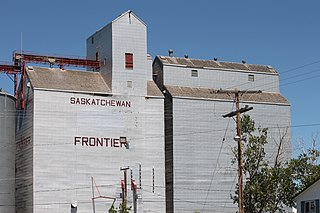
Frontier is a village in the Canadian province of Saskatchewan within the Rural Municipality of Frontier No. 19 and Census Division No. 4. Frontier is on Highway 18 and is served by the Frontier Airport located (3.7 km) south of the village.

Bracken is a village in the Canadian province of Saskatchewan within the Rural Municipality of Lone Tree No. 18 and Census Division No. 4. The village is named after John Bracken, Premier of Manitoba and leader of the Progressive Conservative Party of Canada, who was a professor at the University of Saskatchewan. The small village is located approximately 160 km south of the City of Swift Current on Highway 18, directly north of Grasslands National Park, and approximately 20 km north of the Montana-Saskatchewan border.
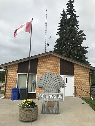
Springside is a town in Saskatchewan, Canada, in the Rural Municipality of Orkney No. 244. It is about 24 kilometres (15 mi) northwest of the city of Yorkton along the Yellowhead Highway.
BulyeaBUUL-yay is a village in the Canadian province of Saskatchewan within the Rural Municipality of McKillop No. 220 and Census Division No. 6.

Forget is a village in the Canadian province of Saskatchewan within the Rural Municipality of Tecumseh No. 65 and Census Division No. 1. It is located east of Stoughton, near Highway 13.

Frobisher is a village in the Canadian province of Saskatchewan within the Rural Municipality of Coalfields No. 4 and Census Division No. 1. It has an elevation of 576 metres above sea level.
Hyas is a village in the Canadian province of Saskatchewan within the Rural Municipality of Clayton No. 333 and Census Division No. 9.
Lintlaw is a village in the Canadian province of Saskatchewan within the Rural Municipality of Hazel Dell No. 335 and Census Division No. 9. The village is located at the intersection of Highway 49 and Highway 617, 142 km northwest of the City of Yorkton.
Minton is a village in the Canadian province of Saskatchewan within the Rural Municipality of Surprise Valley No. 9 and Census Division No. 2. It is on Highway 6 just north of its intersection with Highway 18, 19 km north of the Raymond-Regway Border Crossing on the Montana-Saskatchewan border. The village was named after Minton, Shropshire in England. The name was given by the Canadian Pacific Railway.

The Rural Municipality of Coalfields No. 4 is a rural municipality (RM) in the Canadian province of Saskatchewan within Census Division No. 1 and SARM Division No. 1. Located in the southeast portion of the province, it is adjacent to the United States, neighbouring Burke County, North Dakota.
Weekes is a village in the Canadian province of Saskatchewan within the Rural Municipality of Porcupine No. 395 and Census Division No. 14. The village is located 29 km east of the Town of Porcupine Plain on Highway 23.
Willowbrook is a special service area in the Rural Municipality of Orkney No. 244, Saskatchewan, Canada, that was incorporated as a village prior to July 31, 2008. The community is located 30 km north of the city of Melville at the intersection of Highway 47 and Highway 52.
Wiseton is a village in the Canadian province of Saskatchewan within the Rural Municipality of Milden No. 286 and Census Division No. 12. The village is located at the junction of Highway 44 and Highway 664 approximately 40 km southwest of Outlook.
Ceylon is a village in the Canadian province of Saskatchewan within the Rural Municipality of The Gap No. 39 and Census Division No. 2. It is located alongside Gibson Creek, which is a tributary of Long Creek. No shops or businesses other than the bar remain.
Osage is a village in the Canadian province of Saskatchewan within the Rural Municipality of Fillmore No. 96 and Census Division No. 2. The village is located on Highway 33, that runs south-east from Regina to Stoughton. The village has a grain elevator, post office, service station, and a two-sheet natural ice curling rink. Children from the area attend school in Fillmore, 13 km away. Osage celebrated its centennial in 2006.
| Cities |  | ||||
|---|---|---|---|---|---|
| Towns | |||||
| Villages | |||||
| Rural municipalities | |||||
| First Nations | |||||
| Indian reserves | |||||
| Unincorporated communities |
| ||||
49°57′27″N102°58′19″W / 49.95750°N 102.97194°W
| | This article about a location in the Census Division No. 1 of Saskatchewan is a stub. You can help Wikipedia by expanding it. |