
Wolseley is a town in southeast Saskatchewan, Canada, approximately 100 km east of Regina on the Trans-Canada Highway.
Elkwater is an unincorporated community at the western edge of the Cypress Hills in southeastern Alberta, Canada, 65 kilometres (40 mi) southeast of Medicine Hat. The main access route is via Alberta Highway 41, which leads south from the Trans-Canada Highway.

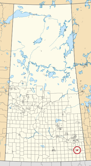
Division No. 1 is one of eighteen census divisions in the province of Saskatchewan, Canada, as defined by Statistics Canada. It is located in the southeast corner of the province, bordering Manitoba and North Dakota. The most populous community in this division is Estevan.

Division No. 7 is one of eighteen census divisions in the province of Saskatchewan, Canada, as defined by Statistics Canada. It is located in the south-central part of the province. The most populous community in this division is Moose Jaw.

Moose Mountain Provincial Park is a provincial park, in south-eastern Saskatchewan about 24 kilometres (15 mi) north of the town of Carlyle on the Moose Mountain Upland. It is one of Saskatchewan's few parks with a community inside the park as there are several subdivisions with both year-round and seasonal residents. The village of Kenosee Lake is completely surrounded by the park but is not part of the park.

Carlyle is a town in the province of Saskatchewan, Canada. Carlyle is the largest town servicing the far south-eastern corner of Saskatchewan and as a result, has become the economic and services centre of the region. Estevan and Weyburn are the closest cities and both are a little over 100 kilometres away. Regina, the provincial capital, lies 200 km to the north-west.

Kenosee Lake is a village in the Canadian province of Saskatchewan within the Rural Municipality of Wawken No. 93 and Census Division No. 1.
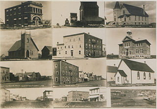
Manor is a village in the Canadian province of Saskatchewan within the RM of Moose Mountain No. 63 and Census Division No. 1. The Manor Museum (1904) is designated a Municipal Heritage Property under the provincial Heritage Property Act.
Arlington Beach is a hamlet in the Canadian province of Saskatchewan. It is located on the eastern shore of Last Mountain Lake, north-west of Regina. Listed as a designated place by Statistics Canada, the hamlet had a population of 39 in the Canada 2006 Census.

Pasqua Lake is a organized hamlet on a lake of the same name in the Qu'Appelle Valley in the Canadian province of Saskatchewan.

Sunset View Beach is an organized hamlet in the Canadian province of Saskatchewan within the RM of Mervin No. 499 and Census Division No. 17. Part of the RM of Parkdale No. 498 prior to September 1992, it subsequently held resort village status until it dissolved to become part of the RM of Mervin No. 499 in January 2015. Sunset View Beach is on the southeast shore of Turtle Lake, approximately 43 km (27 mi) northeast of the Town of Turtleford and 102 km (63 mi) north of the City of North Battleford.

The Rural Municipality of Moose Mountain No. 63 is a rural municipality (RM) in the Canadian province of Saskatchewan within Census Division No. 1 and SARM Division No. 1. It is located in the south-east portion of the province.

The Rural Municipality of Coteau No. 255 is a rural municipality (RM) in the Canadian province of Saskatchewan within Census Division No. 7 and SARM Division No. 3.

The Rural Municipality of Last Mountain Valley No. 250 is a rural municipality (RM) in the Canadian province of Saskatchewan within Census Division No. 11 and SARM Division No. 5.

The Rural Municipality of Parkdale No. 498 is a rural municipality (RM) in the Canadian province of Saskatchewan within Census Division No. 17 and SARM Division No. 6.
White Bear 70 is an Indian reserve of the White Bear First Nations in Saskatchewan. It is 13 kilometres north of Carlyle and encompasses a total of 12,038.4 hectares. In the 2016 Canadian Census, it recorded a population of 691 living in 237 of its 972 total private dwellings. In the same year, its Community Well-Being index was calculated at 60 of 100, compared to 58.4 for the average First Nations community and 77.5 for the average non-Indigenous community.
Moose Mountain Upland, Moose Mountain Uplands, or commonly Moose Mountain, is a hilly plateau located in the south-east corner of the Canadian province of Saskatchewan, that covers an area of about 13,000 km2 (5,000 sq mi). The upland rises about 200 m (660 ft) above the broad, flat prairie which is about 600 m (2,000 ft) above sea level. The highest peak is "Moose Mountain" at 830 m (2,720 ft) above sea level. The area was named Moose Mountain because of the large number of moose that lived in the area. When it was originally used by fur traders, Métis, and the Indigenous peoples, the plateau was called Montagne a la Bosse, which is French for "The Mountain of The Bump or Knob."

White Bear (Carlyle) Lake is a closed-basin lake in the Moose Mountain Upland. It is the largest lake on the plateau, slightly larger than its neighbour, Kenosee Lake. White Bear (Carlyle) Lake is within the White Bear 70 Indian reserve and Carlyle Lake Resort is along the southern shore. The lake and its amenities can be accessed from Highway 9.

Cannington Lake is lake in the Canadian province of Saskatchewan. It is situated at the eastern end of the Moose Mountain Upland in the aspen parkland ecoregion. The western part of the lake is on the White Bear Indian reserve and the eastern part is in the Rural Municipality of Moose Mountain No. 63. The hamlet of Cannington Lake is located at the north-eastern corner of the lake and the nearest highway is Highway 603.


