Rouleau is a town in southern Saskatchewan, Canada, on the Canadian Prairies. It lies within census Division No. 6 and Rural Municipality of Redburn No. 130.
Spiritwood is a town in the boreal forest of central Saskatchewan, Canada with a population of approximately 1,000. Its location is 125 km west of Prince Albert and about 110 km northeast of North Battleford at the junction of Highway 3, Highway 24 and Highway 376. As the largest community in the region, the community functions as the major supply, service, and administrative headquarters for the trading area population which includes several First Nation reserves including Witchekan Lake, Big River, and Pelican Lake.

Davidson is a town in south central Saskatchewan, Canada. It is 104 kilometres (65 mi) south-east of Saskatoon beside provincial highway 11 as well as Highway 44, in the Rural Municipality of Arm River No. 252. Approximately halfway between Saskatoon and Regina, it is a popular stopping point with many restaurants and gas stations located adjacent to the highway.
Unity is a town in the western part of the Canadian province of Saskatchewan with a population of 2573. Unity is located at the intersection of Highway 14 and Highway 21, and the intersection of the CNR and CPR main rail lines. Unity is located 200 kilometres (125 mi) west-northwest of Saskatoon, Saskatchewan, and 375 kilometres (235 mi) southeast of Edmonton, Alberta. The town of Wilkie is located 33 kilometres (21 mi) to the east.

The Rural Municipality of Griffin No. 66 is a rural municipality (RM) in the Canadian province of Saskatchewan within Census Division No. 2 and SARM Division No. 1.

The Rural Municipality of Fillmore No. 96 is a rural municipality (RM) in the Canadian province of Saskatchewan within Census Division No. 2 and SARM Division No. 1. It is located in the south-east portion of the province along Highway 33.
The Rural Municipality of Antler No. 61 is a rural municipality (RM) in the Canadian province of Saskatchewan within Census Division No. 1 and SARM Division No. 1.
Love is a village in the Canadian province of Saskatchewan within the Rural Municipality of Torch River No. 488 and Census Division No. 14. The village is northeast of the City of Prince Albert and about 48 km (30 mi) south of Prince Albert National Park boundaries and 16 km (9.9 mi) south of Torch River Provincial Forest.
Sedley is a village in the Canadian province of Saskatchewan within the Rural Municipality of Francis No. 127 and Census Division No. 6. It is 40 km (25 mi) southeast of the City of Regina on Highway 33. This village is located at the intersection of Highway 33 and Highway 620. Sedley lies in a wheat-producing agricultural district.
Highway 33 is a paved provincial highway in the southern portion of the Canadian province of Saskatchewan connecting Regina to Stoughton; the highway is divided near Regina. Highway 33 is about 139 kilometres (86 mi) long.
Bengough is a town surrounded by the Rural Municipality of Bengough No. 40, in the Canadian province of Saskatchewan. A southeastern Saskatchewan prairie town, Bengough is located east of Willow Bunch Lake on Highway 34 near Highway 705. The town is named Bengough after cartoonist John Wilson Bengough. Bengough also plays host to the Gateway Festival which showcases various musicians and several other events through the weekend, usually taking place in late July.

Carlyle is a town in the province of Saskatchewan, Canada. Carlyle is the largest town servicing the far south-eastern corner of Saskatchewan and as a result, has become the economic and services centre of the region. Estevan and Weyburn are the closest cities and both are a little over 100 kilometres away. Regina, the provincial capital, lies 200 km to the north-west.

Robsart is an unincorporated hamlet within the rural municipality of Reno No. 51, in the Canadian province of Saskatchewan. Robsart had a population of 20 at the 2016 Canada Census. Robsart previously incorporated an independent village since 1912 until it was dissolved into an unincorporated community on January 1, 2002 under the jurisdiction of the rural municipality of Reno No. 51. Robsart is located 48 km southwest of the town of Eastend at the junction of Highway 18 and Highway 13 approximately 170 km south-east of Medicine Hat, Alberta, 68 km south of the Town of Maple Creek.

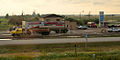
Pense is a town of 603 residents in the southern part of Saskatchewan, Canada. Heading west from Regina on the Trans Canada Highway, Pense is the first community with services. Other communities in the area include Grand Coulee, Belle Plaine, Disley, and Rouleau. Pense is approximately 30 kilometres (19 mi) from the city of Regina.

White Bear is an unincorporated community in the Rural Municipality of Lacadena No. 228, Saskatchewan, Canada. Listed as a designated place by Statistics Canada, the hamlet had a population of 15 in the Canada 2006 Census. The community is approximately 55 mi (89 km) northwest of Swift Current on the north side of the South Saskatchewan River.
McLean is a village in the Canadian province of Saskatchewan within the Rural Municipality of South Qu'Appelle No. 157 and Census Division No. 6. It is on Highway 1 between Qu'Appelle and Balgonie. The village of McLean is located in South Central Saskatchewan on the Trans-Canada Highway and is the highest point on the Canadian Pacific Railway mainline east of the Rockies. It is about 37 kilometres (23 mi) east of the Regina. The population of McLean is 405.

Meota is a village in the Canadian province of Saskatchewan within the Rural Municipality of Meota No. 468 and Census Division No. 17. The village name is derived from the Cree phrase Meotate or Mo-Was-In-Ota, meaning "good place to camp" or "it is good here."

Benson is an unincorporated community in the Canadian province of Saskatchewan. It is located between Estevan and Stoughton on Highway 47. Currently it has a curling rink, community hall and the municipal offices of Rural Municipality of Benson No. 35. The geographical location for Benson is north of the Canada–US border and North Dakota.
Osage is a village in the Canadian province of Saskatchewan within the Rural Municipality of Fillmore No. 96 and Census Division No. 2. The village is located on Highway 33, that runs south-east from Regina to Stoughton. The village has a grain elevator, post office, service station, and a two-sheet natural ice curling rink. Children from the area attend school in Fillmore, 13 km away. Osage celebrated its centennial in 2006.

The Rural Municipality of Bengough No. 40 is a rural municipality (RM) in the Canadian province of Saskatchewan within Census Division No. 2 and SARM Division No. 2. It is located in the southeast portion of the province.