Kerrobert

Last updated
Kerrobert
Town
Kerrobert Court House.JPG
Kerrobert Court House
Canada Saskatchewan location map.svg
Red pog.svg
Kerrobert
Location of Kerrobert in Canada
Coordinates: 51°55′12″N109°07′38″W / 51.92000°N 109.12722°W / 51.92000; -109.12722
Country Canada
Province Saskatchewan
Post Office established:1910
Town 1911
Government
   Mayor Hunter Thomson
   MLA Kindersley Ken Francis (Canadian politician)
   MP Battlefords—Lloydminster Rosemarie Falk
Area
  Total7.49 km2 (2.89 sq mi)
Population
 (2021) [1]
  Total970
  Density114.5/km2 (297/sq mi)
Time zone UTC−6 (Central Standard Time)
  Summer (DST) UTC−5
Postal code
S0L 1R0
Highways Saskatchewan Highway 21 (jct).svgSaskatchewan Highway 31 (jct).svgSaskatchewan Highway 51 (jct).svg Hwy 21  / Hwy 31  / Hwy 51
Website Town of Kerrobert website
[2] [3] [4]

Kerrobert is a town in west central Saskatchewan. It has a population of 970 (2021) [1]

Contents

Kerrobert is served by Highway 21, Highway 31 and Highway 51 as well as the Canadian Pacific Railway. It is approximately 65 kilometres (40 mi) east of the Saskatchewan/Alberta border and 180 kilometres (110 mi) west of Saskatoon.

The town is known for its large water tower, clearly visible from 15 kilometres (10 mi) away.

History

Kerrobert Water Tower Kerrobert Water Tower.JPG
Kerrobert Water Tower

The village began with the name of Hartsberg in 1906, [5] which became Kerr-Robert in 1910, with a final name change in 1924 to Kerrobert. [2]

Historic sites

Kerrobert is home to several historic buildings including the Kerrobert Water Tower (1914), [6] the Kerrobert Library (1910) [7] and the Kerrobert Court House [8]

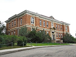
Kerrobert Court House, located in the centre of the town, was built in 1920. It was designed by the Provincial Architect Maurice W. Sharon and built by Wilson and Wilson of Regina for $145,750. The brick and stone structure was the seat of the Kerrobert Judicial District. [5] The former courthouse is currently used as the Town of Kerrobert Municipal office.

Kerrobert Rink

Kerrobert's first rink was built in 1910. A tin covered structure was built in 1911 on the 400 block of Manitoba Ave. The arena was used by citizens of the Kerrobert area until it was destroyed in a tornado in 1919. Metal was sent flying for miles and one man was killed by the flying tin. The insurance of the rink had expired a few days before. Residents went back to skating on the slaughterhouse slough. In 1927 there was a shell built to enclose the rink. On the morning of Nov. 25, 1946 the "old blue rink" was found to be burning. Subsequently, the provincial cabinet decided that Kerrobert would purchase and relocate one of the RCAF hangars located in North Battleford. Construction began on the new rink in August 1947 and was finished November 11. The rink was opened Christmas Day for the first time for public skating and curling. [5]

Demographics

In the 2021 Census of Population conducted by Statistics Canada, Kerrobert had a population of 970 living in 410 of its 494 total private dwellings, a change of -5.5% from its 2016 population of 1,026. With a land area of 8.47 km2 (3.27 sq mi), it had a population density of 114.5/km2 (296.6/sq mi) in 2021. [9]

Canada census – Kerrobert community profile
2021 2016 2011
Population970 (-5.5% from 2016)1,026 (-3.3% from 2011)1,061 (+6.0% from 2006)
Land area8.47 km2 (3.27 sq mi)8.52 km2 (3.29 sq mi)7.49 km2 (2.89 sq mi)
Population density114.5/km2 (297/sq mi)120.4/km2 (312/sq mi)141.7/km2 (367/sq mi)
Median age42.8 (M: 40.4, F: 45.2)41.8 (M: 40.0, F: 43.8)42.2 (M: 39.5, F: 45.2)
Private dwellings494 (total)  410 (occupied)497 (total) 480 (total) 
Median household income$82,000
References: 2021 [10] 2016 [11] 2011 [12] earlier [13] [14]

Climate

Kerrobert experiences a dry semi-arid climate. Winters are long, dry and very cold, while summers are short and warm. Precipitation is low, with an annual average of 342mm (13.5 in), and is heavily concentrated in the warmer months.

Climate data for Kerrobert
MonthJanFebMarAprMayJunJulAugSepOctNovDecYear
Record high °C (°F)8
(46)
8
(46)
18.5
(65.3)
31
(88)
36
(97)
40.5
(104.9)
40.5
(104.9)
38
(100)
36.7
(98.1)
29.5
(85.1)
21.1
(70.0)
11
(52)
40.5
(104.9)
Mean daily maximum °C (°F)−10.3
(13.5)
−7
(19)
0.6
(33.1)
11.4
(52.5)
18.8
(65.8)
22.9
(73.2)
25.5
(77.9)
24.7
(76.5)
18.9
(66.0)
11.4
(52.5)
−0.8
(30.6)
−8.5
(16.7)
9
(48)
Daily mean °C (°F)−15.7
(3.7)
−12.6
(9.3)
−5
(23)
4.2
(39.6)
11
(52)
15.4
(59.7)
17.8
(64.0)
16.7
(62.1)
11.1
(52.0)
4.3
(39.7)
−6.2
(20.8)
−13.7
(7.3)
2.3
(36.1)
Mean daily minimum °C (°F)−20.6
(−5.1)
−17.8
(0.0)
−10.5
(13.1)
−2.9
(26.8)
3.2
(37.8)
7.8
(46.0)
10
(50)
8.6
(47.5)
3.3
(37.9)
−2.8
(27.0)
−11.5
(11.3)
−18.8
(−1.8)
−4.4
(24.1)
Record low °C (°F)−43.5
(−46.3)
−45
(−49)
−37
(−35)
−24
(−11)
−9
(16)
−4.5
(23.9)
1.5
(34.7)
−2.5
(27.5)
−11.5
(11.3)
−27
(−17)
−35.5
(−31.9)
−44.5
(−48.1)
−45
(−49)
Average precipitation mm (inches)12
(0.5)
8.9
(0.35)
13.4
(0.53)
24.1
(0.95)
35.8
(1.41)
65.5
(2.58)
66.9
(2.63)
47.5
(1.87)
26.5
(1.04)
13.8
(0.54)
12.8
(0.50)
14.4
(0.57)
341.7
(13.45)
Source: Environment Canada [15]

Economy

The SaskPower Ermine Power Station is located in Kerrobert, with construction planned to be completed in 2010. [16]

Sports

Every year in March the town of Kerrobert plays host to the Kerrobert Ice Dog Rec Tournament, an ice hockey tournament. [5]

Kerrobert is also home to SWHL all star d man Ethan Osterhold

Kerrobert is home to the Kerrobert Tigers [17] of the Sask West Hockey League (SWHL).

Education

The Kerrobert High School was built in 1959. It had a gymnasium, a library, science lab, and a home economics room. The school was known around the area for its football field and the track around it.

In 1968 the Kerrobert High School was renamed the James Charteris Composite High School. James Charteris had worked at the Kerrobert School Unit Board for 22 years. The JCCS (James Charteris Composite School) schooled grade 7-12 until 1989, when Mary Rodney School closed down and grades K-6 were incorporated into JCCS. At this time, the school was again renamed, becoming Kerrobert Composite School Archived 2010-04-10 at the Wayback Machine or KCS.

At one time, the school's Curling Club included 20 students. In 2003, the team won both the Provincial title and the gold medal in the Canada Winter Games. In 2005, the team won the Provincial Senior Boys Curling Championship as well. [18]

Related Research Articles

Tisdale is the business centre for the rich agricultural boreal forest area in central Saskatchewan, Canada. This town is in the Rural Municipality of Tisdale No. 427, Saskatchewan.

<span class="mw-page-title-main">Biggar, Saskatchewan</span> Town in Saskatchewan, Canada

Biggar is a town in central Saskatchewan, Canada. It is located on Highway 14, 93 kilometres (58 mi) west of Saskatoon, the province's most populous city.

<span class="mw-page-title-main">Wolseley, Saskatchewan</span> Town in Saskatchewan, Canada

Wolseley is a town in southeast Saskatchewan, Canada, approximately 100 km east of Regina on the Trans-Canada Highway.

<span class="mw-page-title-main">Kindersley</span> Town in Saskatchewan, Canada

Kindersley is a town surrounded by the Rural Municipality of Kindersley No. 290 in west-central Saskatchewan, Canada. It is located along Highway 7, a primary highway linking Calgary, Alberta and Saskatoon, at its junction with Highway 21. With a population of 4,567 in 2021, it is an established industrial base for the resource-rich west-central region of the province and a service centre to the oil and gas industry and agriculture production.

Sturgis is a town of 620 people in east-central Saskatchewan, Canada. The Town of Sturgis is 95 km north of Yorkton on Highway 9. It is located in the Assiniboine River valley near the Lakes and Woods region of the province.

<span class="mw-page-title-main">Davidson, Saskatchewan</span> Town in Saskatchewan, Canada

Davidson is a town in south central Saskatchewan, Canada. It is located 104 kilometres (65 mi) south-east of Saskatoon beside provincial highway 11 as well as Highway 44, in the rural municipality of Arm River. Located approximately halfway between Saskatoon and Regina, it is a popular stopping point with many restaurants and gas stations located adjacent to the highway.

<span class="mw-page-title-main">Martensville</span> City in Saskatchewan, Canada

Martensville is a city located in Saskatchewan, Canada, just 8 kilometres (5.0 mi) north of Saskatoon, 10 kilometres (6.2 mi) west of the city of Warman and 14 kilometres (8.7 mi) southwest of Clarkboro Ferry which crosses the South Saskatchewan River. It is a bedroom community of Saskatoon. It is surrounded by the Rural Municipality of Corman Park No. 344. The community is served by the Saskatoon/Richter Field Aerodrome located immediately west of the city across Highway 12, as well as by Saskatoon's John G. Diefenbaker International Airport, only a few miles to the south.

<span class="mw-page-title-main">Blaine Lake</span> Town in Saskatchewan, Canada

Blaine Lake is a town in central Saskatchewan, Canada. It is located 85 km north of Saskatoon, 104 km southwest of Prince Albert and 104 km east of North Battleford at the junction of Highway 12 and Highway 40. Nearby are the urban centres of Shellbrook and Rosthern. Blaine Lake is considered the "Gateway to the Northern Lakes" due to its proximity to fishing, hunting and camping sites, as well as its convenient location at a junction of two highways.

<span class="mw-page-title-main">Perdue, Saskatchewan</span> Village in Saskatchewan, Canada

Perdue is a village in the Canadian province of Saskatchewan within the Rural Municipality of Perdue No. 346 and Census Division No. 12. Perdue is approximately 60 km (37 mi) west of Saskatoon on Highway 14.

Strasbourg is a small town in the Canadian province of Saskatchewan, located about 75 kilometres (47 mi) away from the provincial capital, Regina.

<span class="mw-page-title-main">Arcola, Saskatchewan</span> Town in Saskatchewan, Canada

Arcola is a town in south-east Saskatchewan, Canada, approximately 60 kilometres (37 mi) north and 40 kilometres (25 mi) east of Estevan. Highway 13, Highway 604, and Arcola Airport provide access to the community.

Kamsack, Saskatchewan, Canada is a town in the Assiniboine River Valley, where the Whitesand River joins the Assiniboine River. It is 56 km (35 mi) northeast of Yorkton. Highway 8 and Highway 5 intersect in the town.

Wilkie is a town in the Canadian province of Saskatchewan, located at Section 5, Township 40, Range 19, west of the 3rd Meridian. The town is at the junctions of Highways 14, 29, and 784.

<span class="mw-page-title-main">Elrose, Saskatchewan</span> Town in Saskatchewan, Canada

Elrose is a town located just to the north of the Coteau Hills. It is south of Rosetown and north of Swift Current on Highway 4 and Highway 44. A community in the middle of an agricultural economy, Elrose has also become a local hub of activity in the oil industry. The town is surrounded by the Rural Municipality of Monet No. 257.

<span class="mw-page-title-main">Vanscoy, Saskatchewan</span> Village in Saskatchewan, Canada

Vanscoy is a village in the Canadian province of Saskatchewan within the Rural Municipality of Vanscoy No. 345 and Census Division No. 12. Vanscoy is located on Highway 7 near Highway 762 in central Saskatchewan, 29 km southwest of the City of Saskatoon. Rice Lake is to the west, Goose Lake is to the north, and Pike Lake and Pike Lake Provincial Park are to the east. One of the largest economic industries near Vanscoy is Agrium Vanscoy Potash Operations which produces 1,790,000 metric tonnes of potash a year. Community facilities include a circle hall, ice rink, curling rink and ball diamond.

<span class="mw-page-title-main">Bienfait</span> Town in Saskatchewan, Canada

Bienfait is a town in Saskatchewan on Highway 18 that is 14 kilometres (8.7 mi) east of Estevan. It is 30 kilometres (19 mi) north-west of the town of North Portal, which is next to the Canada–United States border and is also 10 kilometres (6.2 mi) south of Estevan. It is surrounded by the RM of Coalfields.

<span class="mw-page-title-main">Carnduff</span> Town in Saskatchewan, Canada

Carnduff is a small agricultural town in southeast Saskatchewan, Canada.

<span class="mw-page-title-main">Herbert, Saskatchewan</span> Town in Saskatchewan, Canada

Herbert is a town located in the Rural Municipality of Morse No. 165, in southwest Saskatchewan, Canada. The community is 48 km east of the city of Swift Current, and 197 km west of Regina, the provincial capital, on the Trans-Canada Highway. Its population as of 2016 was 856.

<span class="mw-page-title-main">Vonda, Saskatchewan</span> Town in Saskatchewan, Canada

Vonda is located on Highway 27, a half-hour drive north east of Saskatoon, Saskatchewan. The town was named after the daughter of American journalist Cy Warman.

<span class="mw-page-title-main">Young, Saskatchewan</span> Village in Saskatchewan, Canada

Young is a village in the Canadian province of Saskatchewan within the Rural Municipality of Morris No. 312. The economy is dominated by local agriculture and the nearby Mosaic Potash mine.

References

  1. 1 2 "Population and dwelling counts: Canada, provinces and territories, census divisions and census subdivisions (municipalities)". Statistics Canada. Government of Canada. February 9, 2022. Retrieved April 29, 2022.
  2. 1 2 National Archives, Archivia Net. "Post Offices and Postmasters". Archived from the original on 2006-10-06. Retrieved 2013-05-01.
  3. Government of Saskatchewan, MRD Home. "Municipal Directory System". Archived from the original on 2016-01-15. Retrieved 2013-05-01.
  4. Commissioner of Canada Elections, Chief Electoral Officer of Canada (2005). "Elections Canada On-line". Archived from the original on 2007-04-21. Retrieved 2013-05-01.
  5. 1 2 3 4 "Town of Kerrobert website" . Retrieved 2013-05-01.
  6. "Kerrobert Water Tower" . Retrieved 2013-05-01.
  7. "Kerrobert Library" . Retrieved 2013-05-01.
  8. "Kerrobert Court House" . Retrieved 2013-05-01.
  9. "Population and dwelling counts: Canada, provinces and territories, census divisions and census subdivisions (municipalities), Saskatchewan". Statistics Canada. February 9, 2022. Retrieved April 1, 2022.
  10. "2021 Community Profiles". 2021 Canadian Census . Statistics Canada. February 4, 2022. Retrieved 2023-10-19.
  11. "2016 Community Profiles". 2016 Canadian Census . Statistics Canada. August 12, 2021. Retrieved 2022-04-30.
  12. "2011 Community Profiles". 2011 Canadian Census . Statistics Canada. March 21, 2019. Retrieved 2013-05-01.
  13. "2006 Community Profiles". 2006 Canadian Census . Statistics Canada. August 20, 2019.
  14. "2001 Community Profiles". 2001 Canadian Census . Statistics Canada. July 18, 2021.
  15. Environment Canada Canadian Climate Normals 1971–2000, accessed 30 July 2010
  16. Ermine Station [ permanent dead link ]
  17. "Kerrobert Minor Hockey" . Retrieved 2013-05-01.
  18. "Kerrobert Composite School". Archived from the original on 2010-04-10. Retrieved 2009-01-13.

51°55′18″N109°08′26″W / 51.92167°N 109.14056°W / 51.92167; -109.14056