Hafford

Last updated

Hafford, Saskatchewan
Town
HaffordMainStreet.jpg
Main Street Hafford
Canada Saskatchewan location map.svg
Red pog.svg
Location of Hafford in Saskatchewan
Canada location map 2.svg
Red pog.svg
Hafford (Canada)
Coordinates: 52°50′31″N107°22′55″W / 52.842°N 107.382°W / 52.842; -107.382
CountryCanada
Province Saskatchewan
Census division 16
Rural Municipality Redberry
Incorporated (Village)1913
Incorporated (Town)1 January 1981
Government
   Mayor Victoria Moses
  Governing bodyHafford Town Council
   MLA, Rosthern-Shellbrook Scott Moe
(2020)
   MP, Carlton Trail—Eagle Creek Kelly Block
(2021)
Area
[1]
  Total1.13 km2 (0.44 sq mi)
Population
 (2021) [1]
  Total414
  Density366.4/km2 (949/sq mi)
Time zone CST
Postal code
S0J 1A0
Area code(s) 306, 639
Highways Saskatchewan Highway 40 (jct).svg Hwy 40
Saskatchewan Highway 340 (jct).svg Hwy 340
Railways Carlton Trail Railway
[2] [3] [4] [5] [6]

Hafford is a town in the RM of Redberry, Saskatchewan, Canada, consisting of 414 residents at the 2021 Canadian census. It is located near Redberry Lake, which consists of only salt water.

Contents

History

The first overseer for the village of Hafford was T.G. Bavin in 1914. The Hafford Village Council and Board of Trade requested a doctor, and Dr. Whitemarsh was appointed for the village. The early community was first served by Luxembourg Post Office. The early village had three lumber yards, a general store, I.H.C. agency, a poolroom, livery barn, hardware, and post office. In 1913 the Canadian Bank of Commerce and the first restaurant opened. The hotel and bar were established in 1914. Power came to Hafford in 1916, and the Hafford Rural Telephone Company was established in 1916. The Hafford hospital was built in 1922. Hafford was served by the Ukrainian Catholic Church established 1911, the Ukrainian Orthodox church built 1909, the Roman Catholic Church erected about the same time. The Anglican church was built in 1918, and the Methodist church which was erected in Hafford moved to Richard. [2] The Dominion Government Illustration Station was operated between 1932 and 1955. This station tested grains, and fertilizers and improved livestock. [2]

Demographics

In the 2021 Census of Population conducted by Statistics Canada, Hafford had a population of 414 living in 190 of its 221 total private dwellings, a change of

Education

The Hafford community was served firstly by the Whiteberry School District which constructed their school building over two years 1906–1908, opening in 1909 followed by the Rus School District opening 1910. In this area, the Alberton School District, Gooseberry School District, Slawa School District and the Craigmore School District were all organised in 1912. The Hafford School District and Nauka School Districts were organised in 1914, Langley School District 1916, and both the Lost Lake School District, and the Canada School District in 1918. [2]

Transportation

Historically, the railroad connecting Prince Albert and North Battleford was laid in 1913, and upon the rail line, a site was chosen for the village of Hafford site. [2] The community is served by Hafford Airport which is located 1 nautical mile (1.9 km) northwest and formerly by the now removed Carlton Trail Railway that ran parallel to Highway 40.

Notable people

Climate

Climate data for Hafford
MonthJanFebMarAprMayJunJulAugSepOctNovDecYear
Record high °C (°F)9.5
(49.1)
8.5
(47.3)
18
(64)
30.6
(87.1)
35
(95)
37.5
(99.5)
36.5
(97.7)
37
(99)
33
(91)
29.4
(84.9)
18.9
(66.0)
8
(46)
37.5
(99.5)
Mean daily maximum °C (°F)−11.9
(10.6)
−9.3
(15.3)
−1.4
(29.5)
9.9
(49.8)
18.1
(64.6)
21.9
(71.4)
23.9
(75.0)
23.4
(74.1)
16.7
(62.1)
9.9
(49.8)
−3.3
(26.1)
−10.8
(12.6)
7.3
(45.1)
Daily mean °C (°F)−17
(1)
−14.5
(5.9)
−6.9
(19.6)
3.7
(38.7)
11
(52)
15.1
(59.2)
17.2
(63.0)
16.2
(61.2)
10.1
(50.2)
3.7
(38.7)
−7.7
(18.1)
−15.7
(3.7)
1.3
(34.3)
Mean daily minimum °C (°F)−22.2
(−8.0)
−19.7
(−3.5)
−12.2
(10.0)
−2.5
(27.5)
3.9
(39.0)
8.3
(46.9)
10.4
(50.7)
9
(48)
3.4
(38.1)
−2.6
(27.3)
−12.1
(10.2)
−20.5
(−4.9)
−4.7
(23.5)
Record low °C (°F)−46.7
(−52.1)
−42.8
(−45.0)
−37.2
(−35.0)
−28.3
(−18.9)
−9.4
(15.1)
−3.5
(25.7)
0.6
(33.1)
−3.5
(25.7)
−9
(16)
−24
(−11)
−36
(−33)
−43
(−45)
−46.7
(−52.1)
Average precipitation mm (inches)13.7
(0.54)
8.1
(0.32)
13.2
(0.52)
23.1
(0.91)
50.7
(2.00)
67.5
(2.66)
79.3
(3.12)
38.4
(1.51)
39.2
(1.54)
14.8
(0.58)
13.9
(0.55)
14.2
(0.56)
375.9
(14.80)
Source: Environment Canada [7]

See also

Bilingual street sign Ukrainian Sign Hafford Saskatchewan 2011.jpg
Bilingual street sign

Related Research Articles

Quill Lake is a village in the Canadian province of Saskatchewan within the Rural Municipality of Lakeside No. 338 and Census Division No. 10. It is 170 km east of Saskatoon and 200 km northeast of Regina.

<span class="mw-page-title-main">Canora, Saskatchewan</span> Town in Saskatchewan, Canada

Canora is a town, located at the junction of highways No. 5 and 9 in east central Saskatchewan, about 50 km north of Yorkton. It is centrally located on the corners of four adjacent rural municipalities, including the RM of Good Lake. The community is home to approximately 3,500 residents and is part of the Canora-Pelly electoral district. The community was founded along the Canadian Northern Railway tracks - one of the companies that evolved into the Canadian National Railway (CN), and two CN freight lines still run through Canora. The Canora railway station, downtown on the CN east-west line before the switch to the northbound line, is served by Via Rail on its passenger service from Winnipeg to Churchill, Manitoba. As of 2016, 53% of the town’s residents are either from Ukraine or of Ukrainian descent, with the language still widely spoken in the community.

<span class="mw-page-title-main">Alvena</span> Village in Saskatchewan, Canada

Alvena is a village in the Canadian province of Saskatchewan within the Rural Municipality of Fish Creek No. 402 and Census Division No. 15. It is approximately 60 kilometres (37 mi) northeast of Saskatoon.

Arran is a special service area in the Canadian province of Saskatchewan within the Rural Municipality of Livingston No. 331 and Census Division No. 9. It held village status between 1916 and 2022.

<span class="mw-page-title-main">Division No. 16, Saskatchewan</span> Census division of Saskatchewan, Canada

Division No. 16 is one of eighteen census divisions in the province of Saskatchewan, Canada, as defined by Statistics Canada. It is located in the north-central part of the province. The most populous community in this division is North Battleford.

<span class="mw-page-title-main">Rural Municipality of Eye Hill No. 382</span> Rural municipality in Saskatchewan, Canada

The Rural Municipality of Eye Hill No. 382 is a rural municipality (RM) in the Canadian province of Saskatchewan within Census Division No. 13 and SARM Division No. 6. It is located in the west-central portion of the province adjacent to the Alberta boundary.

<span class="mw-page-title-main">Rural Municipality of Oakdale No. 320</span> Rural municipality in Saskatchewan, Canada

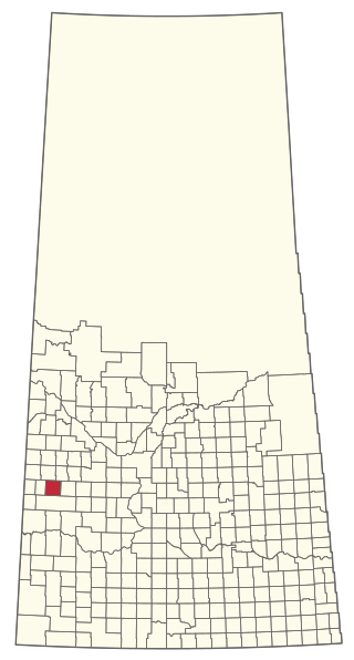
The Rural Municipality of Oakdale No. 320 is a rural municipality (RM) in the Canadian province of Saskatchewan within Census Division No. 13 and SARM Division No. 6. Located in the west-central portion of the province, it is near the Alberta boundary.

<span class="mw-page-title-main">Rural Municipality of Blaine Lake No. 434</span> Rural municipality in Saskatchewan, Canada

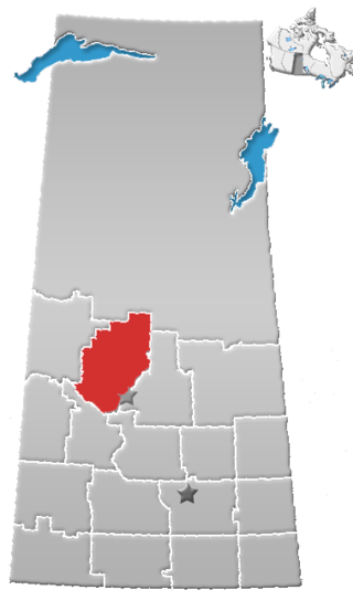
The Rural Municipality of Blaine Lake No. 434 is a rural municipality (RM) in the Canadian province of Saskatchewan within Census Division No. 16 and SARM Division No. 5. The RM extends east to the North Saskatchewan River and north to the village of Marcelin.

Calder is a village in the Canadian province of Saskatchewan within the Rural Municipality of Calder No. 241 and Census Division No. 9. The village lies approximately 56 km east of the City of Yorkton and 35 km west of Roblin, Manitoba, approximately 5 km south of Highway 8 and Highway 10.

Dorintosh is a village in the Canadian province of Saskatchewan within the Rural Municipality of Meadow Lake No. 588 and Census Division No. 17.

<span class="mw-page-title-main">Englefeld, Saskatchewan</span> Village in Saskatchewan, Canada

Englefeld is a village in the Canadian province of Saskatchewan within the Rural Municipality of St. Peter No. 369 and Census Division No. 15. The village is located 32 kilometres east of the City of Humboldt on Highway 5.

<span class="mw-page-title-main">Harris, Saskatchewan</span> Village in Saskatchewan, Canada

Harris is a village in the Canadian province of Saskatchewan within the Rural Municipality of Harris No. 316 and Census Division No. 12. It was the site of the Great Ruby Hoax in 1914. Harris was named for Richard Elford Harris, an early settler to the area.

<span class="mw-page-title-main">Kinley, Saskatchewan</span> Village in Saskatchewan, Canada

Kinley is a village in the Canadian province of Saskatchewan within the Rural Municipality of Perdue No. 346 and Census Division No. 12. The village of Kinley is located about 55 km west of the City of Saskatoon on Highway 14, between the communities of Perdue 10 km west and Asquith 17 km east.

<span class="mw-page-title-main">Krydor, Saskatchewan</span> Village in Saskatchewan, Canada

Krydor is a village in the Canadian province of Saskatchewan within the Rural Municipality of Redberry No. 435 and Census Division No. 16. The community's name is a combination of the names of two early settlers, Petro Krysak and Teodor Lucyk. Petro Krysak also served as the first postmaster, from September 1, 1911, to July 7, 1913.

Lake Lenore is a village in the Canadian province of Saskatchewan within the Rural Municipality of St. Peter No. 369 and Census Division No. 15. The village is located 144 kilometres (89 mi) northeast of the city of Saskatoon. To the north of the village is Lenore Lake, which is designated as a migratory bird sanctuary, an Important Bird Area (IBA) of Canada, and has a National Wildlife Area on Raven Island. Services in Lake Lenore include a school, Co-op Grocery and Agro Service Station, a Credit Union, and Public Library.

<span class="mw-page-title-main">Redberry Lake (Saskatchewan)</span> Salt lake in Saskatchewan, Canada

Redberry Lake is a lake near Hafford in the Canadian province of Saskatchewan. It is a medium-sized saline lake within an area characterized by mostly freshwater aquatic environments. The lake makes up the core protected area of the Redberry Lake (UNESCO) Biosphere Reserve, and is a federal bird sanctuary of the same name. It is an Important Bird Area (IBA) of Canada designated as Redberry Lake . A small regional park is situated at the north-west corner of the lake. The countryside surrounding Redberry Lake is typical of the aspen parkland biome of which it is a part.

Redberry was a provincial electoral district for the Legislative Assembly of the province of Saskatchewan, Canada, centred on the town of Hafford. This constituency was one of 25 created before the 1st Saskatchewan general election in 1905. Dissolved in 1934, the district was reconstituted before the 9th Saskatchewan general election in 1938, and renamed "Redberry Lake" in 1995.

Primate is a special service area within the Rural Municipality of Eye Hill No. 382, Saskatchewan, Canada that held village status prior to 2016.

<span class="mw-page-title-main">Pinehouse</span> Village in Saskatchewan, Canada

Pinehouse is a northern village located in the boreal forest of Saskatchewan on the western shore of Pinehouse Lake within the Canadian Shield.

<span class="mw-page-title-main">Rural Municipality of Redberry No. 435</span> Rural municipality in Saskatchewan, Canada

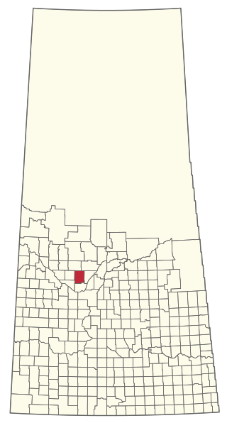
The Rural Municipality of Redberry No. 435 is a rural municipality (RM) in the Canadian province of Saskatchewan within Census Division No. 16 and SARM Division No. 5.

References

  1. 1 2 3 "Population and dwelling counts: Canada, provinces and territories, census divisions and census subdivisions (municipalities), Saskatchewan". Statistics Canada. 9 February 2022. Retrieved 1 April 2022.
  2. 1 2 3 4 5 Hafford District History Committee (c. 1955), Holotta, M.W.; Lommer, M; Oschipok, P.J. (eds.), Sketches of Hafford and District, p. 9
  3. National Archives, Archivia Net, Post Offices and Postmasters, archived from the original on 6 October 2006
  4. Government of Saskatchewan, MRD Home, Municipal Directory System, archived from the original on 21 November 2008
  5. Canadian Textiles Institute. (2005), CTI Determine your provincial constituency, archived from the original on 11 September 2007
  6. Commissioner of Canada Elections, Chief Electoral Officer of Canada (2005), Elections Canada On-line, archived from the original on 21 April 2007
  7. Environment Canada Canadian Climate Normals 1971–2000, accessed 27 July 2010

52°50′31″N107°22′55″W / 52.842°N 107.382°W / 52.842; -107.382