Wilkie, Saskatchewan

Last updated

Wilkie
Town
Canada Saskatchewan location map.svg
Red pog.svg
Wilkie
Location of Wilkie in Saskatchewan
Coordinates: 52°24′32″N108°42′00″W / 52.409°N 108.7°W / 52.409; -108.7
CountryCanada
Province Saskatchewan
Census division 13
Rural Municipality Buffalo No. 409
Post Office Founded1907
Government
   Mayor David Ziegler
  AdministratorLana Gerein
  Governing bodyWilkie Town Council
Area
  Total9.48 km2 (3.66 sq mi)
Population
 (2011) [1]
  Total1,301
  Density137.3/km2 (356/sq mi)
Time zone CST
Postal code
S0K 4W0
Area code 306
Highways Highway 29 Highway 14
Website Official website
[2] [3]

Wilkie is a town in the Canadian province of Saskatchewan, located at Section 5, Township 40, Range 19, west of the 3rd Meridian (of the Dominion Land Survey). The town is at the junctions of Highways 14, 29, and 784.

Contents

Wilkie is surrounded by the RM of Buffalo No. 409 to the north and the RM of Reford No. 379 to the south.

History

On February 2, 1907, the first post office was established with the name Glenlogan at Section 4, Township 40, Range 19, west of the 3rd Meridian. The post office changed names on October 1, 1908 to Wilkie. The town of Wilkie, Saskatchewan was named after Mr. Daniel Robert Wilkie, who was the president of the Imperial Bank of Canada (1906–1914), a backer of the Canadian Pacific Railway, and a member of the Canadian Art Club. Mr. Wilkie and his family lived at "Seven Oaks", a heritage property at 432 Sherbourne Street, Toronto, which was completed in 1875. His son, Major Arthur Benson Wilkie, graduated from the Royal Military College of Canada and served with the Royal Sussex Regiment (1901–1920) in Lucknow, India (1902); Thorncliffe, England (1903–04); Malta (1904–05); Candia, Crete (1906); British Legation, Peking (1908); and Toronto, Ontario (1910–1920). His other son Major Charles Stuart (Chas) Wilkie served as a lieutenant with the Royal Canadian Artillery (1899–1919) and volunteered with the 10th Regiment in South Africa during the Boer War (1899–1900) and during the Great War.

Wilkie was once home to "The World's Largest Grasshopper" (a roadside attraction), which used to be located in front of the town rink and hall.

Transportation

Wilkie is a station on the Canadian Pacific Railway line from Portage la Prairie, via Saskatoon to Edmonton, 160 kilometres west of Saskatoon. Wilkie is also the starting point of Canadian Pacific's Reford Branch, to Kerrobert, 44.6 miles (71.8 km) to the south-west, and of the former Kelfield Branch, of the CPR, to Kelfield, 35.4 miles (57.0 km) south.

Adjacent to Wilkie is the abandoned aerodrome, Wilkie Airport. [4]

Parks and recreation

Wilkie Regional Park ( 52°24′46″N108°42′53″W / 52.4127°N 108.7147°W / 52.4127; -108.7147 ) is a regional park that was established on February 24, 1970 on land owned by the town. The park is well treed and features 22 campsites, four ball diamonds, and a picnic area. It is located along the west side of town along Highway 29. [5] [6]

On the south side of town is Wilkie Golf Club. It is a 9-hole golf course with grass greens. [7]

The Wilkie Saskcan Community Centre has an ice rink and curling rink. On October 9, 2015, an electrical fire caused significant damage to the building. [8] In 2019, Wilkie was a top four Kraft Hockeyville finalist. Funds from that and a campaign started by Brett Wilson, raised $126,000 for a new ice plant for the facility. Installation of the new ice plant started in the summer of 2021 and was up and running by September 29, 2021. [9]

Demographics

In the 2021 Census of Population conducted by Statistics Canada, Wilkie had a population of 1,195 living in 509 of its 569 total private dwellings, a change of -2% from its 2016 population of 1,219. With a land area of 9.22 km2 (3.56 sq mi), it had a population density of 129.6/km2 (335.7/sq mi) in 2021. [10]

Canada census – Wilkie, Saskatchewan community profile
2011
Population1,301 (+6.5% from 2006)
Land area9.48 km2 (3.66 sq mi)
Population density137.3/km2 (356/sq mi)
Median age47.4 (M: 46.4, F: 48.0)
Total private dwellings598
Median household income
References: 2011 [11] earlier [12] [13]

Education

Wilkie is home to Norman Carter Elementary School (k–6) and McLurg High School (7–12).

Latimer controversy

Wilkie was the site of the controversial murder of Tracy Latimer, a 12-year-old girl with cerebral palsy, on October 24, 1993. Her father, Robert Latimer, killed her via carbon monoxide poisoning at the Latimer family farm near Wilkie, wanting to end her suffering. The case sparked a national controversy on the definition and ethics of euthanasia, as well as the rights of people with disabilities. The killing led to two Supreme Court decisions, R. v. Latimer (1997), on Section Ten of the Canadian Charter of Rights and Freedoms, and later R. v. Latimer (2001), on cruel and unusual punishments under Section Twelve of the Canadian Charter of Rights and Freedoms. Latimer was released on day parole in March 2008 and was granted full parole on November 29, 2010. [14]

See also

Related Research Articles

<span class="mw-page-title-main">Battleford</span> Town in Saskatchewan, Canada

Battleford is a town located across the North Saskatchewan River from the City of North Battleford, in Saskatchewan, Canada.

<span class="mw-page-title-main">Biggar, Saskatchewan</span> Town in Saskatchewan, Canada

Biggar is a town in central Saskatchewan, Canada. It is located on Highway 14, 93 kilometres (58 mi) west of Saskatoon, the province's most populous city.

<span class="mw-page-title-main">Kindersley</span> Town in Saskatchewan, Canada

Kindersley is a town surrounded by the Rural Municipality of Kindersley No. 290 in west-central Saskatchewan, Canada. It is located along Highway 7, a primary highway linking Calgary, Alberta and Saskatoon, at its junction with Highway 21. With a population of 4,567 in 2021, it is an established industrial base for the resource-rich west-central region of the province and a service centre to the oil and gas industry and agriculture production.

<span class="mw-page-title-main">Allan, Saskatchewan</span> Town in Saskatchewan, Canada

Allan is a town in west central Saskatchewan, Canada, about 65 kilometres south-east of Saskatoon.

<span class="mw-page-title-main">Delisle, Saskatchewan</span> Town in Saskatchewan, Canada

Delisle is a town in south central Saskatchewan, Canada. It is located 45 kilometres (28 mi) southwest of Saskatoon beside Highway 7.

<span class="mw-page-title-main">Radville</span> Town in Saskatchewan, Canada

Radville is a small town in Canadian province of Saskatchewan, in the RM of Laurier No. 38. It was incorporated in 1911 after being settled in 1895. Highway 28 and Highway 377 pass through the town. Nearby communities include the village of Ceylon, 23 km to the west, and the city of Weyburn, 51 km to the north-east. Major nearby urban centres include Regina, which is 148 km to the north, and Moose Jaw, which is 143 km north-west.

<span class="mw-page-title-main">Martensville</span> City in Saskatchewan, Canada

Martensville is a city located in Saskatchewan, Canada, just 8 kilometres (5.0 mi) north of Saskatoon, 10 kilometres (6.2 mi) west of the city of Warman and 14 kilometres (8.7 mi) southwest of Clarkboro Ferry which crosses the South Saskatchewan River. It is a bedroom community of Saskatoon. It is surrounded by the Rural Municipality of Corman Park No. 344. The community is served by the Saskatoon/Richter Field Aerodrome located immediately west of the city across Highway 12, as well as by Saskatoon's John G. Diefenbaker International Airport, only a few miles to the south.

<span class="mw-page-title-main">Wakaw</span> Town in Saskatchewan, Canada

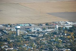
Wakaw, Saskatchewan, is a town 90 kilometres (56 mi) northeast of Saskatoon and 66 kilometres (41 mi) south of Prince Albert. It is about halfway between the two cities and is served by Highway 2, Highway 41, and Highway 312. Wakaw is in hilly partially forested country east of the South Saskatchewan River. The area is part of the aspen parkland biome.

Landis is a village in the Canadian province of Saskatchewan within the Rural Municipality of Reford No. 379 and Census Division No. 13. The village is about 51 km (32 mi) south of Wilkie and about 128 km (80 mi) west from the City of Saskatoon on Highway 14. From 1907 to 1909, the post office at Section 23, Township 37, Range 18 west of the 3rd meridian, was known as Daneville. In 1925, Landis was a Canadian National Railway Station on the Grand Trunk Pacific Railway line.

<span class="mw-page-title-main">Outlook, Saskatchewan</span> Town in Saskatchewan, Canada

Outlook is a town in west central Saskatchewan, Canada about 80 kilometres (50 mi) south-southwest of Saskatoon. It is located along the South Saskatchewan River, downstream from Gardiner Dam and the Coteau Creek Hydroelectric Station.

<span class="mw-page-title-main">Unity, Saskatchewan</span> Town in Saskatchewan, Canada

Unity is a town in the western part of the Canadian province of Saskatchewan with a population of 2573. Unity is located at the intersection of Highway 14 and Highway 21, and the intersection of the CNR and CPR main rail lines. Unity is located 200 km (125 mi) west-northwest of Saskatoon, Saskatchewan, and 375 km (235 mi) southeast of Edmonton, Alberta. The town of Wilkie is located 33 km (21 mi) to the east.

<span class="mw-page-title-main">Perdue, Saskatchewan</span> Village in Saskatchewan, Canada

Perdue is a village in the Canadian province of Saskatchewan within the Rural Municipality of Perdue No. 346 and Census Division No. 12. Perdue is approximately 60 km (37 mi) west of Saskatoon on Highway 14.

Strasbourg is a small town in the Canadian province of Saskatchewan, located about 75 km away from the provincial capital, Regina.

<span class="mw-page-title-main">Lanigan, Saskatchewan</span> Town in Saskatchewan, Canada

Lanigan is a town in south-central Saskatchewan, Canada, at the intersection of TransCanada Yellowhead Highway 16 and Highway 20, approximately 117 km east of Saskatoon and 170 km north of Regina.

<span class="mw-page-title-main">Craik, Saskatchewan</span> Town in Saskatchewan

Craik is a town in south central Saskatchewan, Canada, incorporated on August 1, 1907. It is strategically located along Provincial Highway 11 in the RM of Craik No. 222, 140 km south-east of Saskatoon and 117 km north-west of Regina.

Arborfield is a town in east-central Saskatchewan, Canada, approximately 70 km (43 mi) north-east of Melfort. The town is located on Highway 23 14 km (8.7 mi) west of the Pasquia Hills. Arborfield is approximately 54 km (34 mi) from Nipawin, 53 km (33 mi) from Tisdale, 266 km (165 mi) from Saskatoon, and 196 km (122 mi) from Prince Albert.

<span class="mw-page-title-main">Arcola, Saskatchewan</span> Town in Saskatchewan, Canada

Arcola is a town in south-east Saskatchewan, Canada, approximately 60 kilometres (37 mi) north and 40 kilometres (25 mi) east of Estevan. Highway 13, Highway 604, and Arcola Airport provide access to the community.

<span class="mw-page-title-main">Regina Beach</span> Town in Saskatchewan, Canada

Regina Beach is a town in south central Saskatchewan, located on Highway 54, close to where Highway 11 intersects with the Qu'Appelle Valley.

<span class="mw-page-title-main">Naicam</span> Town in Saskatchewan, Canada

Naicam is a small town in rural Saskatchewan, located 224 km (139 mi) north of the province's capital city, Regina. In 2006 the population was 690. The name of the town is a combination of Naismith and Cameron, the railway construction contractors.

<span class="mw-page-title-main">Mortlach, Saskatchewan</span> Village in Saskatchewan, Canada

Mortlach is a village in the Canadian province of Saskatchewan within the Rural Municipality of Wheatlands No. 163 and Census Division No. 7. The village is on the Trans Canada Highway about 40 km west of the City of Moose Jaw. Thunder Creek passes the community to the north where it is joined by Sandy Creek. Mortlach became a village on April 19, 1906, and is one of two towns in Saskatchewan to have been incorporated as a town to then be reverted to village status on January 1, 1949; the other is the village of Alsask.

References

  1. "2011 Community Profiles". Statistics Canada. Government of Canada. Retrieved March 20, 2014.
  2. National Archives, Archivia Net. "Post Offices and Postmasters" . Retrieved March 20, 2014.
  3. Government of Saskatchewan, MRD Home. "Municipal Directory System" . Retrieved March 20, 2014.
  4. Canada Flight Supplement. Effective 0901 Z 16 July 2020 to 0901Z 10 September 2020.
  5. "Wilkie Regional Park | Tourism Saskatchewan".
  6. "Wilkie".
  7. "Wilkie Golf Club | Tourism Saskatchewan".
  8. "Saskcan Community Center".
  9. "New ice plant a result of Hockeyville winnings".
  10. "Population and dwelling counts: Canada, provinces and territories, census divisions and census subdivisions (municipalities), Saskatchewan". Statistics Canada. February 9, 2022. Retrieved April 1, 2022.
  11. "2011 Community Profiles". 2011 Canadian Census . Statistics Canada. March 21, 2019. Retrieved January 13, 2013.
  12. "2006 Community Profiles". 2006 Canadian Census . Statistics Canada. August 20, 2019.
  13. "2001 Community Profiles". 2001 Canadian Census . Statistics Canada. July 18, 2021.
  14. "The law and Robert Latimer (CBC)" . Retrieved April 12, 2013.

52°25′N108°42′W / 52.417°N 108.700°W / 52.417; -108.700 (Wilkie, Saskatchewan)