Rockglen

Last updated

Rockglen
Nickname: 
Fully Modern
Canada Saskatchewan location map.svg
Red pog.svg
Rockglen
Location of Rockglen in Saskatchewan
Canada location map 2.svg
Red pog.svg
Rockglen
Rockglen (Canada)
Coordinates: 49°11′0″N105°57′0″W / 49.18333°N 105.95000°W / 49.18333; -105.95000
CountryCanada
Incorporated1927
Government
   Mayor Erwin Jackson
   Member of Legislative Assembly Dave Marit (SKP)
   Member of Parliament Jeremy Patzer (CPC)
Area
  Total2.85 km2 (1.69 sq mi)
Population
 (2011)
  Total400
  Density140.4/km2 (364/sq mi)
Time zone UTC−6 (Central Standard Time)
Website https://rockglensk.ca/

Rockglen [1] is a town in the Burning Hills of the Wood Mountain Uplands, in Saskatchewan, Canada. It offers various amenities including a school, community hall, public library and five parks, as well a local service industry. The municipal office of the Rural Municipality of Poplar Valley No. 12 lies within the boundaries of Rockglen, and Rockglen businesses are supported primarily by agriculture. In the Burning Hills agriculture consists of dry land farming and cattle. Rockglen is located along Highway 2 south of Assiniboia, Highway 18 west of Coronach, and Highways 2 and 18 north of Port Poplar River. Fife Lake is 9.3 kilometres (5.8 mi) to the east. [2]

Contents

History

Vestiges from before the last ice age, a land of hidden treasures, petrified wood and fossils, hammers and arrows of the Assiniboine, Plains Cree, and Blackfoot peoples. But it is the followers of Sitting Bull who left one of the strongest impressions. Following the Battle of Little Bighorn 5,000 Lakota Sioux Lakota fled to the Wood Mountain Uplands where they were under the jurisdiction of the North-West Mounted Police under the command of Major James Morrow Walsh. The hills, first surveyed by the Henry Youle Hind expedition in 1858, were used for hunting by day, and at night fires could be seen of meat being smoked. In 1879 the U.S. Cavalry set fires in Montana that spread and burned the grasslands of Rockglen, causing the ensuing famine and leading to the toponym "The Burning Hills".

It is in these Burning Hills where the Ferbane ranch was located. By 1910 the homestead became a post office, soon German and Austro-Hungarian settlers built homesteads out of tar paper shacks and sod huts. Wood building were built for businesses, such as the pool hall, which also contained the Wesley Methodist church, which became the Wesley United Church of Canada in 1925; Valley City became an unofficial community.

To the north the Kent homestead became a post office in 1915. Soon thereafter Beromé Prefontaine built a store and by 1917 Joeville, named for Joseph Prefontaine, was founded as a village. In 1926 Joeville was a prosperous community when the Canadian Pacific Railway constructed a rail line south from Assiniboia, Saskatchewan. The Saskatchewan Wheat Pool and Alberta Pacific both built elevators along the line. Joeville split into the French community of Liseux near the new elevators and 26 buildings were moved south to the new CPR junction near Valley City. Valley City was relocated north of the tracks and incorporated as the Village of Rockglen in 1927.

Services were soon established in the tiny village. Mr. Sproul ran a school out of the Pinking Hotel on Centre Street. It was a community effort with desks and blackboards furnished by local carpenters and fundraising organized by Mr. Sproul. To the relief of Centre Street commerce a proper school house was built in 1928. It had three rooms: Mr. Preston as principal and two classes instructed by Miss Campbell and Miss Jarvis. In 1929 the Red Cross built a hospital, and a permanent post office was built, as was a branch of the Imperial Bank of Canada, and Charlie Switallo’s hardware store, which was the longest running Rockglen business to date.

Electric lighting was provided from 1929–1950 by the Rockglen Power Company, which ran every day from dusk to midnight, when three flashes indicated shut down. It wasn’t until 1950 when the Saskatchewan Power Corporation came to Rockglen that full 24-hour 120- and 240-volt electric service came to Rockglen.

The depression caused rural decline which was furthered by mechanization of agriculture during the later stages and in the time following the Second World War. Nearby Constance and Strathcona were dissolved and the one-room rural school houses were replaced by a system of buses and Bombardier tracked vehicles for winter use. Rockglen grew to a population of 500 persons when incorporated as a town with L. J. Bolster elected the first mayor. During the 1960s a new school was constructed, as well as a new post office, school office, Imperial Bank of Canada, and hotel.

The late 1970s saw a rise of inflation, combined with exceptionally high grain prices; many farmers retired and moved into Rockglen. In 1975 construction began on the Poplar River Power Station in nearby Coronach commissioned in 1981. 1981 also saw the construction of a new Saskatchewan Wheat Pool elevator. This is currently the last elevator in Rockglen and is owned by Poplar Valley Producers Co-operative. The resulting population influx had led to development of homes along Second Avenue and construction of Hillcrest Drive. To date, these are the newest housing developments in Rockglen. In 1988, Rockglen resident Jack Wolfe was elected as a Progressive Conservative Member of Legislative Assembly a position in which he served until 1991.

Since the 1970s residents of the area have claimed sightings of a humanoid figure, similar to a Bigfoot or Sasquatch, living near or on "Columbus" (a hill within the town). It has been described as ape-like in appearance and standing between 8 and 10 feet tall with a shrill voice and skunk-like in fragrance. Locals have named the creature "Zoobey" sometimes spelled "Zoobie" or shortened to "Zoobs". A small number of Rockglenites known as "The Zoob Troob" follow news regarding the creature and circulate a limited number, biannual newsletter called "The Zoobey Sask-watch". Some believe efforts have been made to cover up the existence of Zoobey while others believe the creature does not exist and claim never to have heard of it.

Current government

As a town Rockglen has a mayor fulfilling executive duties and a town council to pass bylaws. At present His Worship, Erwin Jackson is mayor. The judicial role is fulfilled by the provincial government in accordance with the Municipal Act.

Demographics

In the 2021 Census of Population conducted by Statistics Canada, Rockglen had a population of 399 living in 199 of its 237 total private dwellings, a change of

Economy

Rockglen provides services to surrounding farms, ranches, feedlots, and employees of the Poplar River power station and nearby Poplar River Mine, in addition to a significant retirement population.

The only light industry, though it too could be considered a service, is that of Nielson's Welding along Highway #2. The largest economic contributor is the Rockglen Co-op, which is the largest co-op south of Assiniboia, Saskatchewan, and through sales of products such as lumber to Montana cattlemen attracts a significant amount of foreign business.

Rail transit was privately owned by the Canadian Pacific Railway until a shortline was taken over by Southern Rails Cooperative in 2006; Rockglen is now a transfer point between Southern Rails Cooperative and the Canadian Pacific Railway. [4]

Transportation

Sports teams

Notable people

See also

Related Research Articles

<span class="mw-page-title-main">Lafleche, Saskatchewan</span> Town in Saskatchewan, Canada

Lafleche is a small town in southwest Saskatchewan, Canada in the Rural Municipality of Wood River No. 74. The community is located at the intersection of Highway 13 and Highway 58. It is 20 km south of Gravelbourg and 45 km west of Assiniboia. It is situated on the south bank of Lafleche Creek, which is a tributary of Wood River. Thomson Lake Regional Park is located 10 minutes north of town.

<span class="mw-page-title-main">Assiniboia, Saskatchewan</span> Town in Saskatchewan

Assiniboia is a town in the Canadian province of Saskatchewan. It is located 110 km (68 mi) south-southwest of Moose Jaw beside Highway 2 and Highway 13.

<span class="mw-page-title-main">Grenfell, Saskatchewan</span> Town in Saskatchewan, Canada

Grenfell is a town in Southern Saskatchewan, Canada. It is situated at the junction of Highway 47 and the Trans-Canada Highway 1 80 miles (130 km) east of Regina, the provincial capital. It is 15 miles (24 km) south of the Qu'Appelle Valley where Crooked Lake Provincial Park and Bird's Point Resort are popular beach destinations in summer and are accessed by Highway 47.

<span class="mw-page-title-main">Qu'Appelle, Saskatchewan</span> Town in Saskatchewan, Canada

Qu'Appelle is a town in Saskatchewan, located on Highway 35 approximately 50 kilometres (31 mi) east of the provincial capital of Regina.

<span class="mw-page-title-main">Willow Bunch, Saskatchewan</span> Town in Saskatchewan, Canada

Willow Bunch is a town in Saskatchewan, Canada. It is located 190 kilometres (120 mi) southwest of the provincial capital of Regina. Its population was 299 at the 2021 census.

Fife Lake is a hamlet located between Coronach and Rockglen within Rural Municipality of Poplar Valley No. 12 in south-central Saskatchewan, Canada near the border with the United States. Approximately 40 people inhabited the village of Fife Lake in 2006. It is about 11 kilometres (6.8 mi) east of Rockin Beach Park and Fife Lake.

<span class="mw-page-title-main">Coronach, Saskatchewan</span> Town in Saskatchewan, Canada

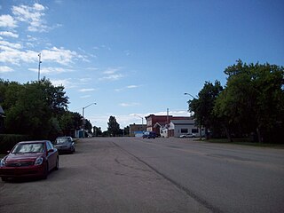
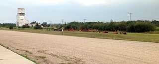
Coronach is a community in southern Saskatchewan, Canada near the Canada–US border. It was founded in 1926 by the Canadian Pacific Railway and named after Coronach, the horse who had just won The Derby in England that year. Coronach was officially incorporated in 1928.

<span class="mw-page-title-main">Division No. 3, Saskatchewan</span> Census division of Saskatchewan, Canada

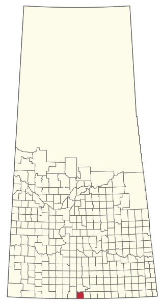
Division No. 3 is one of eighteen census divisions in the province of Saskatchewan, Canada, as defined by Statistics Canada. It is located in the south-southwestern part of the province, adjacent to the border with Montana, United States. The most populous community in this division is Assiniboia.

Highway 2 is a provincial highway in the Canadian province of Saskatchewan. It is the longest highway in Saskatchewan at 809 km (503 mi). The highway has a few divided sections but is mostly undivided. However, only about 18 kilometres (11 mi) near Moose Jaw, 11 kilometres (7 mi) near Chamberlain, and 21 kilometres (13 mi) near Prince Albert are divided highway. Highway 2 is a major north-south route beginning at the Canada–US border at the Port of West Poplar River and Opheim, Montana customs checkpoints. Montana Highway 24 continues south. It passes through the major cities of Moose Jaw in the south and Prince Albert in the north. Highway 2 overlaps Highway 11 between the towns of Chamberlain and Findlater. This 11 kilometres (7 mi) section of road is a wrong-way concurrency. The highway ends at La Ronge, where it becomes Highway 102.

<span class="mw-page-title-main">Saskatchewan Highway 35</span> Provincial highway in Saskatchewan, Canada

Highway 35 is a paved undivided provincial highway in the Canadian province of Saskatchewan.. It runs from the US Border near Port of Oungre to a dead end near the north shore of Tobin Lake. Saskatchewan Highway 35 (SK Hwy 35) is about 569 kilometres (354 mi) long. The CanAm Highway comprises Saskatchewan Highways 35, SK Hwy 39, SK Hwy 6, SK Hwy 3, SK Hwy 2 and U.S. Route 85. 74.6 kilometres (46.4 mi) of SK Hwy 35 contribute to the CanAm Highway between Port of Oungre on the Canada – United States border and Weyburn. Mudslides, and spring flooding were huge road building and maintenance problems around Nipawin as well as along the southern portion of the route named the Greater Yellow Grass Marsh. Over 20 early dams were built until the problem was addressed with the Rafferty-Alameda Project on the Souris River and the construction of the Qu'Appelle River Dam which have helped to eliminate washed out roads and flooded communities. The highway through the homesteading community followed the Dominion Land Survey on the square until reaching the Saskatchewan River at Nipawin. The completion of the combined railway and traffic bridge over the Saskatchewan River at Nipawin in the late 1920s retired the ferry and basket crossing for traffic north of Nipawin. The E.B. Campbell Dam built in 1963 northeast of Nipawin created Tobin Lake, and Codette Lake was formed with the construction of the Francois-Finlay Hydroelectric dam at Nipawin. The railway/traffic bridge that formed part of Highway 35 was the only crossing utilized at Nipawin until a new traffic bridge was constructed in 1974. The new bridge then became part of the combined Highway 35 and 55 until the highway parts just east of White Fox. Highway 35 then continued north along the west side of Tobin Lake. The railway/traffic bridge continues to be utilized for one lane vehicle traffic controlled by traffic lights, and continues as the "old highway 35" on the west side of the river until it joins with the current Highway 35/55.

<span class="mw-page-title-main">Kenaston, Saskatchewan</span> Village in Saskatchewan, Canada

Kenaston is a village in the Canadian province of Saskatchewan within the Rural Municipality of McCraney No. 282 and Census Division No. 11. Kenaston is located on Highway 11 at the junction of Highway 15 and is also near Highway 19. This is a scenic area of Saskatchewan situated within the rolling Allan Hills. Kenaston is located between Danielson Provincial Park and Blackstrap Provincial Park.

Bengough is a town surrounded by the rural municipality of Bengough No. 40, in the Canadian province of Saskatchewan. A southeastern Saskatchewan prairie town, Bengough is located east of Willow Bunch Lake on Highway 34 near Highway 705. The town is named Bengough after cartoonist John Wilson Bengough. Bengough also plays host to the Gateway Festival which showcases various musicians and several other events through the weekend, usually taking place in late July.

<span class="mw-page-title-main">Rama, Saskatchewan</span> Village in Saskatchewan, Canada

Rama is a village in the Canadian province of Saskatchewan within the Rural Municipality of Invermay No. 305 and Census Division No. 9. It is located 44 km west of Canora and 60 km east of Wadena at the intersection of Highway 5 and Highway 754.

Ruthilda is a former village in the Rural Municipality of Grandview No. 349, Saskatchewan, Canada. It dissolved from village status to become part of the Rural Municipality of Grandview No. 349 on December 31, 2013. Ruthilda is located about 5 km south of Highway 51 approximately 30 km southwest of the Town of Biggar.

<span class="mw-page-title-main">Rural Municipality of Hart Butte No. 11</span> Rural municipality in Saskatchewan, Canada

The Rural Municipality of Hart Butte No. 11 is a rural municipality (RM) in the Canadian province of Saskatchewan within Census Division No. 3 and SARM Division No. 2. Located in the south-central portion of the province, it is adjacent to the United States boundary, neighbouring Daniels County in Montana.

<span class="mw-page-title-main">Rural Municipality of Poplar Valley No. 12</span> Rural municipality in Saskatchewan, Canada

The Rural Municipality of Poplar Valley No. 12 is a rural municipality (RM) in the Canadian province of Saskatchewan within Census Division No. 3 and SARM Division No. 2. It is located in the southern portion of the province. It is adjacent to the United States border, neighbouring Daniels County in Montana.

The Southern Rails Cooperative Ltd. (SRCL) is a Canadian short line railway company operating on trackage in southwest Saskatchewan. Southern Rails Cooperative was the first shortline railway to operate in Saskatchewan and operated as the first modern common carrier shortline railway. The railway is a farmer owned co-operative that operates two short-line railways in Saskatchewan, totalling 71 km of trackage: the former Canadian Pacific Railway Colony subdivision that runs from Rockglen to Killdeer, and the former Canadian National Railway Avonlea subdivision that runs from Avonlea to Parry, The company subsequently expanded along the Avonlea subdivision into Moose Jaw.

The Fife Lake Railway is a Canadian shortline railway company operating on trackage in Saskatchewan, Canada. The railway is owned by seven local municipalities. The Fife Lake Railway took over the former Canadian Pacific Railway Fife Lake subdivision consisting of 94 km of trackage.

<span class="mw-page-title-main">Horizon, Saskatchewan</span> Unincorporated Community in Saskatchewan, Canada

Horizon, located on the south side of Channel Lake, is a hamlet in Bengough Rural Municipality No. 40, Saskatchewan, Canada. It previously held the status of village until December 31, 1973. The hamlet is located 60 km (37 mi) east of the Town of Assiniboia on highway 13.

Fife Lake is a fresh water prairie lake in the Canadian province of Saskatchewan. It is in the south-central part of the province at the eastern end of the Wood Mountain Hills. The entire lake and its shoreline is designated an Important Bird Area (IBA) of Canada to protect the nationally endangered piping plover. While there are no communities along the lake's shore, there is a park and campground at the southern end. Nearby communities include Fife Lake, Rockglen, and Lisieux. Access is from Highway 18.

References

  1. "Rockglen". Canadian Geographical Names Database. Government of Canada. Retrieved 7 January 2023.
  2. "Rockin Beach Park". Tourism Saskatchewan. Government of Saskatchewan. Retrieved 7 January 2023.
  3. "Population and dwelling counts: Canada, provinces and territories, census divisions and census subdivisions (municipalities), Saskatchewan". Statistics Canada. 9 February 2022. Retrieved 1 April 2022.
  4. "Southern Rails Cooperative LTD. - Overview". Archived from the original on 16 July 2011. Retrieved 30 November 2010.
  5. Fife Lake Railway Project Best Practice Report
  6. "Mandel, Miriam, 1930-1982," Special Collections, University of Calgary Library, UCalgary.ca, Web, Apr, 24, 2011.