Arbuthnot, Saskatchewan

Last updated

Arbuthnot
Canada Saskatchewan location map.svg
Red pog.svg
Arbuthnot
Coordinates: 49°49′N106°54′W / 49.817°N 106.900°W / 49.817; -106.900 Coordinates: 49°49′N106°54′W / 49.817°N 106.900°W / 49.817; -106.900
Country Canada
Province Saskatchewan
Region south-central
Census division 3
Rural Municipality Glen Bain
Government
  Type Glen Bain Rural Municipality
Time zone UTC-6 (CST)
Area code 306
Highways Highway 43
Railway Canadian Pacific Railway
[1] [2] [3] [4]

Arbuthnot (also known as Westlake, Ville Bouvier) is an unincorporated community located in Glen Bain Rural Municipality No. 105, Saskatchewan, Canada east of Route 19. It was located in census Division No. 2. It was on mile 63 of the Canadian Pacific Railway right of way, southeast of Swift Current and in the NW section 9- township 10- range 7 west of the third meridian.

Contents

Residential code 105.10 Regional Health Authority: Five Hills.

Demographics

Arbuthnot was enumerated and administrated by the Glen Bain Rural Municipality. All that remains is one home.

History

Etymology Named, according to E.T.Russell, after Sir Robert Arbuthnot, 4th Bt (1864–1916) or (less probably) after John Arbuthnot. [5] Arbuthnot, Saskatchewan was located about 150 kilometres (93 mi) southwest of the City of Moose Jaw, just off of secondary road #611. While it does still appear on the map, the community was never incorporated as a village or town and is not listed in the municipal directory.

From Bill Barry's People Places: A Historical Gazetteer of Saskatchewan. The Canadian Pacific Railway built a station at this location between Vanguard and Meyronne in 1932. The preferred name of the settlers had been Stapleton after a pioneer settler, but the CPR held firm on its choice for its siding and the post office (which was open 1932-1969) followed suit. [6]

The boom The rural municipality office put out a history book which listed some facts of this community which boomed around the 1940s. Andrew Miller Jr opened the general store in April 1935. In 1936 Andrew Miller Jr built a dance hall which was sold to John Silzer in 1939 and which burned down after a dance in 1942. Joe Schlageter opened a blacksmith's shop from 1936–40. The first school building was moved into Arbuthnot in May 1944 from Jim Thomas Sr's farm and was converted into a classroom. This was used until the Glen Rosa School was moved into Arbuthnot in the summer of 1949. This building was used until 1957. The school was bought by Arbuthnot Ladies Club. They later donated it to the Glen Bain Lions Club who moved it to Glen Bain 24 June 1981. Exy Grad had a motor service garage next to and north of Andrew J Miller's General Store. Peter Harms bought the General Store from Mr Miller around 1940 and operated it until it burned down on 2 December 1946. Mr Harms sold the store business to Peter Donauer and he opened a store on 18 December 1946 in the building which had previously been used as a school. He built a brand new store in 1947. Peter sold the store to F J Bolen on 24 September 1953. Frank and Tema Bolen operated the store until 1958. The store building was sold to John Thomas and he moved it to his farm south of Meyronne.

The decline The post office remained in the Bolen's store building until 1968. The first post office had been in the home of Mrs I P Johnston at the north end of the community and it was later moved into the general store.

The Arbuthnot Co-op was incorporated in 1935 and was managed in turn by Ed Faber, Charles Becker, Edwin Hepper, Bill Schlichting and Henry Schlageter. It was dissolved in 1963.

The Saskatchewan Pool elevator and the Pioneer Grain elevator were built in 1935. They built a house for the pool agent in 1947. The Saskatchewan Wheat Pool sold their elevator to the Pioneer Co. on 31 July 1974 and moved it to Aneroid on 21 August 1974. The Pioneer elevator was used until early 1984. It was demolished and burned on 21 December 1984. The Pioneer Elevator was managed by Dan Kohlenberg from Bateman, a community 25 miles (40 km) to the northeast of Arbuthnot. The Imperial Oil company was located on the west side of the road between Arbuthnot Hall (to the north) and Arbuthnot Co-op (to the south). It was managed by Herman Silzer. The Canadian Oil Co was managed by P Harms. [7]

Education

Arbuthnot no longer has a school, but those who live in or around Arbuthnot are sent to the neighbouring village of Gravelbourg which has a school that covers Kindergarten to Grade 12 serving approximately N/A students.

See also

Related Research Articles

<span class="mw-page-title-main">Grain elevator</span> Grain storage building

A grain elevator is a facility designed to stockpile or store grain. In the grain trade, the term "grain elevator" also describes a tower containing a bucket elevator or a pneumatic conveyor, which scoops up grain from a lower level and deposits it in a silo or other storage facility.

Coleville is a village in the Canadian province of Saskatchewan within the Rural Municipality of Oakdale No. 320 and Census Division No. 13. The village's main economic factors are oil and farming, namesake of the Coleville oilfields. The village is named for Malcolm Cole who became the community's first postmaster in 1908.

<span class="mw-page-title-main">Sintaluta</span> Town in Saskatchewan, Canada

Sintaluta is a small town in Saskatchewan, Canada. The current population of Sintaluta is approximately 119 people according to the 2016 Canadian Census. The town is located about 85 km east of Regina. The town is located on the north side of the Trans-Canada Highway.

<span class="mw-page-title-main">Lafleche, Saskatchewan</span> Town in Saskatchewan, Canada

Lafleche is a small town in southwest Saskatchewan, Canada in the Rural Municipality of Wood River No. 74. The community is located at the intersection of Highway 13 and Highway 58. It is 20 km south of Gravelbourg and 45 km west of Assiniboia. It is situated on the south bank of Lafleche Creek, which is a tributary of Wood River. Thomson Lake Regional Park is located 10 minutes north of town.

<span class="mw-page-title-main">Radville</span> Town in Saskatchewan, Canada

Radville is a small town in Canadian province of Saskatchewan. The town is in the RM of Laurier No. 38. It was incorporated in 1911 after being settled in 1895. Highway 28 and Highway 377 pass through the town. Nearby communities include the village of Ceylon, 23 km to the west, and the city of Weyburn, 51 km to the north-east. Major nearby urban centres include Regina, which is 148 km to the north, and Moose Jaw, which is 143 km north-west.

<span class="mw-page-title-main">Willow Bunch, Saskatchewan</span> Town in Saskatchewan, Canada

Willow Bunch is a town in Saskatchewan, Canada. It is located 190 kilometres (120 mi) southwest of the provincial capital of Regina. The population was 286 at the 2011 census.

Rockglen is a town in the Burning Hills of the Wood Mountain Uplands, in Saskatchewan, Canada, providing a school, community hall, public library and five parks, as well a local service industry. The municipal office of Rural Municipality of Poplar Valley No. 12 lies within the boundaries of Rockglen, and Rockglen businesses are supported primarily by agriculture. In the Burning Hills agriculture consists of dry land farming and cattle. Rockglen is located along Highway 2 south of Assiniboia, Highway 18 west of Coronach, and Highways 2 and 18 north of Port Poplar River. Fife Lake is 9.3 kilometres (5.8 mi) to the east.

<span class="mw-page-title-main">Western Development Museum</span>

The Western Development Museum is a network of four museums in Saskatchewan, Canada preserving and recording the social and economic development of the province. The museum has branches in Moose Jaw, North Battleford, Saskatoon and Yorkton. Respectively, each branch focuses on a different theme: transportation, agriculture, economy, and people. The museum is affiliated with the Canadian Museums Association, the Canadian Heritage Information Network, and Virtual Museum of Canada.

<span class="mw-page-title-main">Division No. 3, Saskatchewan</span> Census division in Saskatchewan in Canada

Division No. 3 is one of eighteen census divisions in the province of Saskatchewan, Canada, as defined by Statistics Canada. It is located in the south-southwestern part of the province, adjacent to the border with Montana, United States. The most populous community in this division is Assiniboia.
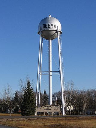
<span class="mw-page-title-main">Ogema, Saskatchewan</span> Town in Saskatchewan, Canada

Ogema is a town with a population of 403 located in south Central Saskatchewan, Canada. It is approximately 115 kilometres (71 mi) south of Saskatchewan's capital city, Regina, and about midway between Weyburn and Assiniboia on Saskatchewan Highway 13.

Love is a village in the Canadian province of Saskatchewan within the Rural Municipality of Torch River No. 488 and Census Division No. 14. The village is northeast of the City of Prince Albert and about 48 km (30 mi) south of Prince Albert National Park boundaries and 16 km (9.9 mi) south of Torch River Provincial Forest.

<span class="mw-page-title-main">Crichton, Saskatchewan</span> Unincorporated community in Saskatchewan, Canada

Crichton is an unincorporated community within the Rural Municipality of Wise Creek No. 77, Saskatchewan, Canada. It is located between Admiral and Cadillac on the historic Red Coat Trail, also known as Highway 13. Like so many towns along the Red Coat Trail, Crichton has become a ghost town with only one family remaining and many empty buildings scattered throughout the town site.

Govenlock is an unincorporated community within Rural Municipality of Reno No. 51, Saskatchewan, Canada. It previously held the status of a village, with a peak population of 151 residents; its village status was dissolved on January 1, 1976. The former townsite of Govenlock is located on Highway 21 & Highway 13, also known as the historic Red Coat Trail, about 15 km east of the Alberta-Saskatchewan border. Although many cement foundations and wooden sidewalks can still be found scattered around the town site, the only building that still stands as of 2010 is the old community hall and a commemorative plaque in remembrance of Govenlock's rich history.

<span class="mw-page-title-main">Bents, Saskatchewan</span> Unincorporated community in Saskatchewan, Canada

Bents is an unincorporated community in Marriott No. 317, Saskatchewan, Canada. Prior to the town founding, the area was referred to as Piche. Bents took its name from Longniddry Bents in Scotland. Its derelict wooden grain elevator was once the subject of a National Geographic photograph. The remnants of the town are now located on private property.

<span class="mw-page-title-main">Altario</span> Hamlet in Alberta, Canada

Altario is a hamlet in east-central Alberta, Canada within Special Area No. 4. It is located on Highway 899 just north of Highway 12, approximately 12 kilometres (7.5 mi) east of Kirriemuir and 14 kilometres (8.7 mi) west of Compeer.

<span class="mw-page-title-main">Rural Municipality of Glen Bain No. 105</span> Rural Municipality in Saskatchewan, Canada

The Rural Municipality of Glen Bain No. 105 is a rural municipality (RM) in the Canadian province of Saskatchewan within Census Division No. 3 and SARM Division No. 3. It is located in the south-central portion of the province.

Old Wives is an unincorporated community in the Rural Municipality of Hillsborough No. 132, Saskatchewan, Canada.

<span class="mw-page-title-main">Farrow, Alberta</span> Unincorporated community in Alberta, Canada

Farrow is an unincorporated community in Vulcan County, Alberta, Canada. The community is located 5 km off of Highway 24 on Township road 202, about 25 km north of Vulcan and 82 km southeast of the City of Calgary. The community has been completely abandoned and is now owned by a local farmer. Most of the remaining buildings of the former community including a Church/school, a house, a fallen store, and out buildings have all been demolished completely. The remains can now be seen from aboard the Aspen crossing railway.

<span class="mw-page-title-main">Horizon, Saskatchewan</span> Unincorporated Community in Saskatchewan, Canada

Horizon, located on the south side of Channel Lake, is a hamlet in Bengough Rural Municipality No. 40, Saskatchewan, Canada. It previously held the status of village until December 31, 1973. The hamlet is located 60 km (37 mi) east of the Town of Assiniboia on highway 13.

References

  1. National Archives, Archivia Net, Post Offices and Postmasters, archived from the original on 2006-10-06
  2. Government of Saskatchewan, MRD Home, Municipal Directory System, archived from the original on November 21, 2008
  3. Canadian Textiles Institute. (2005), CTI Determine your provincial constituency, archived from the original on 2007-09-11
  4. Commissioner of Canada Elections, Chief Electoral Officer of Canada (2005), Elections Canada On-line - Home, archived from the original on 2007-04-21
  5. Russell, Edmund Thomas Pete (1997), What's in a name? : the story behind Saskatchewan place names, Calgary: Fifth House Publishers, ISBN   1-895618-98-3
  6. Barry, Bill, People Places: The Historical Gazetteer of Saskatchewan, vol. Version 2.1.7, archived from the original on 2007-10-18
  7. Mulatz, Frank; Glen Bain No. 105, Glen Bain Historical Society (1988), Whispering winds of yesteryear : Glen Bain R.M. #10.5, Glen Bain, Sask., ISBN   0-919781-72-1